Burnet County Sketch File 20
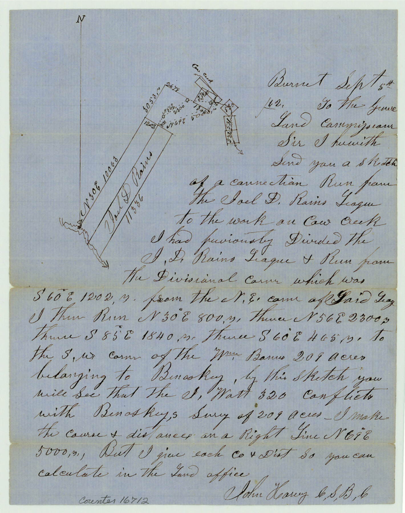
[Sketch of a connection run from the Joel D. Rains league on the Colorado River to work on Cow Creek]
-
Map/Doc
16712
-
Collection
General Map Collection
-
Object Dates
1862/9/5 (Creation Date)
1862/9/11 (File Date)
-
People and Organizations
John Harvey (Surveyor/Engineer)
-
Counties
Burnet
-
Subjects
Surveying Sketch File
-
Height x Width
10.1 x 8.0 inches
25.7 x 20.3 cm
-
Medium
paper, manuscript
-
Features
Cow Creek
[Colorado River]
Part of: General Map Collection

Anderson County Boundary File Index

Print $2.00
- Digital $50.00
Anderson County Boundary File Index
Size 9.1 x 3.3 inches
Map/Doc 49725
La Salle County Working Sketch 22

Print $20.00
- Digital $50.00
La Salle County Working Sketch 22
1942
Size 36.2 x 29.2 inches
Map/Doc 70323
Henderson County Rolled Sketch 11

Print $20.00
- Digital $50.00
Henderson County Rolled Sketch 11
1915
Size 29.4 x 42.5 inches
Map/Doc 75946
Flight Mission No. DAG-23K, Frame 187, Matagorda County

Print $20.00
- Digital $50.00
Flight Mission No. DAG-23K, Frame 187, Matagorda County
1953
Size 17.5 x 22.4 inches
Map/Doc 86522
Cherokee County Sketch File 3

Print $4.00
- Digital $50.00
Cherokee County Sketch File 3
1849
Size 7.5 x 11.0 inches
Map/Doc 18115
Jeff Davis County Rolled Sketch 46

Print $134.00
- Digital $50.00
Jeff Davis County Rolled Sketch 46
2006
Size 17.5 x 24.0 inches
Map/Doc 87213
Roberts County Rolled Sketch 1

Print $20.00
- Digital $50.00
Roberts County Rolled Sketch 1
Size 18.4 x 23.5 inches
Map/Doc 7510
[Texas & Pacific Railway through Callahan County]
![64233, [Texas & Pacific Railway through Callahan County], General Map Collection](https://historictexasmaps.com/wmedia_w700/maps/64233.tif.jpg)
Print $20.00
- Digital $50.00
[Texas & Pacific Railway through Callahan County]
1918
Size 20.5 x 9.4 inches
Map/Doc 64233
Flight Mission No. DIX-10P, Frame 143, Aransas County

Print $20.00
- Digital $50.00
Flight Mission No. DIX-10P, Frame 143, Aransas County
1956
Size 18.8 x 22.5 inches
Map/Doc 83945
Smith County Working Sketch 10

Print $20.00
- Digital $50.00
Smith County Working Sketch 10
1952
Size 33.4 x 24.2 inches
Map/Doc 63895
Soil Map - Ohio-Michigan, Toledo Set

Print $20.00
- Digital $50.00
Soil Map - Ohio-Michigan, Toledo Set
1902
Size 21.4 x 30.5 inches
Map/Doc 3023
You may also like
Sundown Located on Tracts Number 58 and 59 Bob Slaughter Block Hockley County, Texas

Print $20.00
- Digital $50.00
Sundown Located on Tracts Number 58 and 59 Bob Slaughter Block Hockley County, Texas
1928
Size 21.4 x 19.4 inches
Map/Doc 92233
Nueces County Sketch File 83

Print $63.00
- Digital $50.00
Nueces County Sketch File 83
1997
Size 11.1 x 8.5 inches
Map/Doc 43013
Ector County Sketch File 12

Print $12.00
- Digital $50.00
Ector County Sketch File 12
1956
Size 11.4 x 9.0 inches
Map/Doc 21645
General Highway Map, Hunt County, Texas

Print $20.00
General Highway Map, Hunt County, Texas
1961
Size 24.7 x 18.2 inches
Map/Doc 79528
Flight Mission No. DCL-7C, Frame 45, Kenedy County

Print $20.00
- Digital $50.00
Flight Mission No. DCL-7C, Frame 45, Kenedy County
1943
Size 15.4 x 15.3 inches
Map/Doc 86033
Flight Mission No. DCL-7C, Frame 22, Kenedy County

Print $20.00
- Digital $50.00
Flight Mission No. DCL-7C, Frame 22, Kenedy County
1943
Size 15.4 x 15.2 inches
Map/Doc 86014
Baylor County Sketch File 12A

Print $8.00
- Digital $50.00
Baylor County Sketch File 12A
1900
Size 9.3 x 7.3 inches
Map/Doc 14148
Frio County Working Sketch 20

Print $20.00
- Digital $50.00
Frio County Working Sketch 20
1985
Size 36.3 x 36.0 inches
Map/Doc 69294
Controlled Mosaic by Jack Amman Photogrammetric Engineers, Inc - Sheet 37

Print $20.00
- Digital $50.00
Controlled Mosaic by Jack Amman Photogrammetric Engineers, Inc - Sheet 37
1954
Size 20.0 x 24.0 inches
Map/Doc 83492
Map showing survey for proposed ship channel from Brownsville to Brazos Santiago Pass

Print $20.00
- Digital $50.00
Map showing survey for proposed ship channel from Brownsville to Brazos Santiago Pass
1912
Size 18.1 x 28.0 inches
Map/Doc 72899
Anderson County Sketch File 19

Print $40.00
- Digital $50.00
Anderson County Sketch File 19
Size 18.2 x 15.9 inches
Map/Doc 10802
Flight Mission No. DAG-18K, Frame 75, Matagorda County

Print $20.00
- Digital $50.00
Flight Mission No. DAG-18K, Frame 75, Matagorda County
1952
Size 18.5 x 19.1 inches
Map/Doc 86368