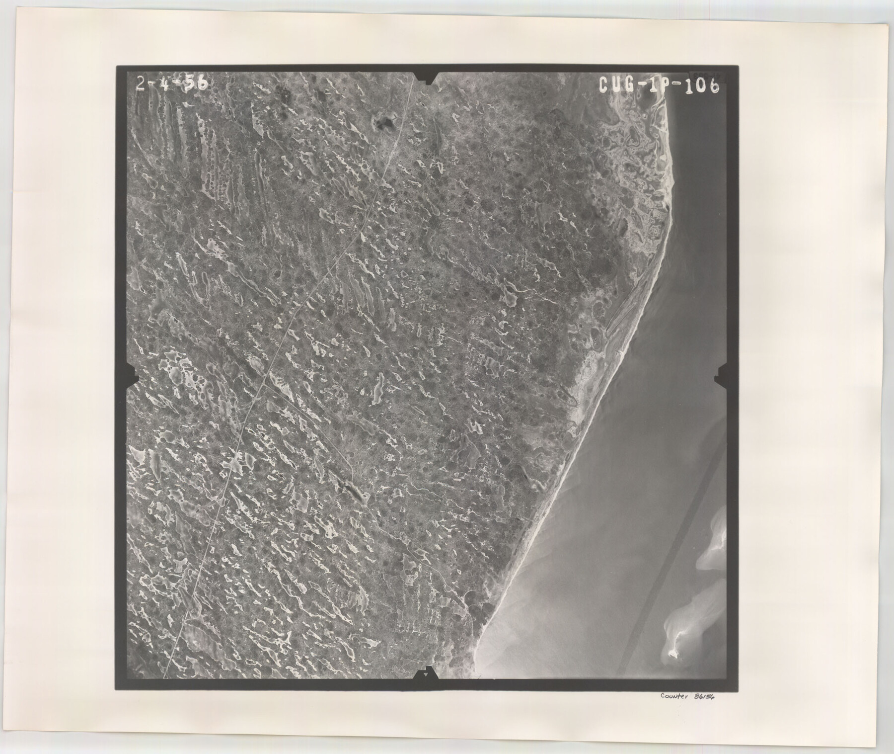
Flight Mission No. CUG-1P, Frame 106, Kleberg County
CUG-1P-106
-
Map/Doc
86156
-
Collection
General Map Collection
-
Object Dates
1956/2/4 (Creation Date)
-
People and Organizations
U. S. Department of Agriculture (Publisher)
-
Counties
Kleberg
-
Subjects
Aerial Photograph
-
Height x Width
18.8 x 22.3 inches
47.8 x 56.6 cm
-
Comments
Flown by V. L. Beavers and Associates of San Antonio, Texas.
Part of: General Map Collection
Hudspeth County Sketch File 31

Print $20.00
- Digital $50.00
Hudspeth County Sketch File 31
1908
Size 18.7 x 17.7 inches
Map/Doc 11805
[Surveys in Liberty County]
![69750, [Surveys in Liberty County], General Map Collection](https://historictexasmaps.com/wmedia_w700/maps/69750.tif.jpg)
Print $2.00
- Digital $50.00
[Surveys in Liberty County]
Size 5.8 x 9.3 inches
Map/Doc 69750
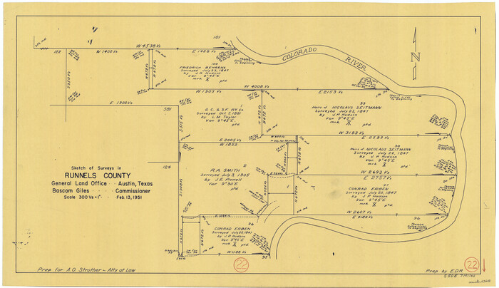
Runnels County Working Sketch 22
Print $20.00
- Digital $50.00
Runnels County Working Sketch 22
1951
Size 16.2 x 28.1 inches
Map/Doc 63618
Flight Mission No. CGN-3P, Frame 140, San Patricio County

Print $20.00
- Digital $50.00
Flight Mission No. CGN-3P, Frame 140, San Patricio County
1956
Size 18.5 x 22.3 inches
Map/Doc 86984
Smith County Sketch File 12

Print $4.00
- Digital $50.00
Smith County Sketch File 12
1859
Size 8.3 x 12.0 inches
Map/Doc 36769
Orange County Rolled Sketch 24

Print $245.00
- Digital $50.00
Orange County Rolled Sketch 24
1950
Size 10.5 x 15.4 inches
Map/Doc 47946
Coast Chart No. 210 - Aransas Pass and Corpus Christi Bay with the coast to latitude 27° 12', Texas

Print $20.00
- Digital $50.00
Coast Chart No. 210 - Aransas Pass and Corpus Christi Bay with the coast to latitude 27° 12', Texas
1900
Size 18.3 x 23.6 inches
Map/Doc 73448
[County Line between DeWitt and Lavaca Counties]
![65355, [County Line between DeWitt and Lavaca Counties], General Map Collection](https://historictexasmaps.com/wmedia_w700/pdf_converted_jpg/qi_pdf_thumbnail_19782.jpg)
Print $226.00
- Digital $50.00
[County Line between DeWitt and Lavaca Counties]
1906
Size 17.4 x 34.4 inches
Map/Doc 65355
Right of Way and Track Map, International & Gt. Northern Ry. Operated by the International & Gt. Northern Ry. Co., Gulf Division

Print $40.00
- Digital $50.00
Right of Way and Track Map, International & Gt. Northern Ry. Operated by the International & Gt. Northern Ry. Co., Gulf Division
1917
Size 25.1 x 56.6 inches
Map/Doc 64252
Angelina County Sketch File 23a

Print $4.00
- Digital $50.00
Angelina County Sketch File 23a
1904
Size 11.2 x 8.6 inches
Map/Doc 13063
Newton County Working Sketch 25

Print $20.00
- Digital $50.00
Newton County Working Sketch 25
1953
Size 25.4 x 23.8 inches
Map/Doc 71271
Map of Palo Pinto County, east of the Brazos River, Robertson - west of it, Milam Land District

Print $20.00
- Digital $50.00
Map of Palo Pinto County, east of the Brazos River, Robertson - west of it, Milam Land District
1859
Size 27.4 x 22.3 inches
Map/Doc 3935
You may also like
Terry County Rolled Sketch 4

Print $20.00
- Digital $50.00
Terry County Rolled Sketch 4
Size 38.7 x 36.8 inches
Map/Doc 9994
Map of the CB Live Stock Co. -N- Ranch situated in Crosby County, Texas

Print $20.00
- Digital $50.00
Map of the CB Live Stock Co. -N- Ranch situated in Crosby County, Texas
Size 21.2 x 38.1 inches
Map/Doc 90332
Carte de la Louisiane et du Cours du Mississipi

Print $20.00
Carte de la Louisiane et du Cours du Mississipi
1718
Size 16.6 x 21.8 inches
Map/Doc 89216

El Paso County Boundary File 22

Print $4.00
- Digital $50.00
El Paso County Boundary File 22
Size 13.6 x 8.6 inches
Map/Doc 53216
Hemphill County Rolled Sketch 2

Print $20.00
- Digital $50.00
Hemphill County Rolled Sketch 2
Size 26.4 x 29.8 inches
Map/Doc 6185
Motley County Boundary File 2c

Print $34.00
- Digital $50.00
Motley County Boundary File 2c
Size 14.2 x 8.7 inches
Map/Doc 57533
Duval County Working Sketch 6

Print $20.00
- Digital $50.00
Duval County Working Sketch 6
1935
Size 26.9 x 21.8 inches
Map/Doc 68719
Mason County Sketch File 1

Print $6.00
- Digital $50.00
Mason County Sketch File 1
1857
Size 11.0 x 8.2 inches
Map/Doc 30677
Kimble County Sketch File 36

Print $20.00
- Digital $50.00
Kimble County Sketch File 36
1963
Size 22.2 x 25.0 inches
Map/Doc 11932
Harris County Working Sketch 87

Print $20.00
- Digital $50.00
Harris County Working Sketch 87
1972
Size 34.1 x 31.0 inches
Map/Doc 65979
[Triangulation Net of Part of Texas. Travis County to Red River]
![3101, [Triangulation Net of Part of Texas. Travis County to Red River], General Map Collection](https://historictexasmaps.com/wmedia_w700/maps/3101.tif.jpg)
Print $20.00
- Digital $50.00
[Triangulation Net of Part of Texas. Travis County to Red River]
1928
Size 28.2 x 33.9 inches
Map/Doc 3101