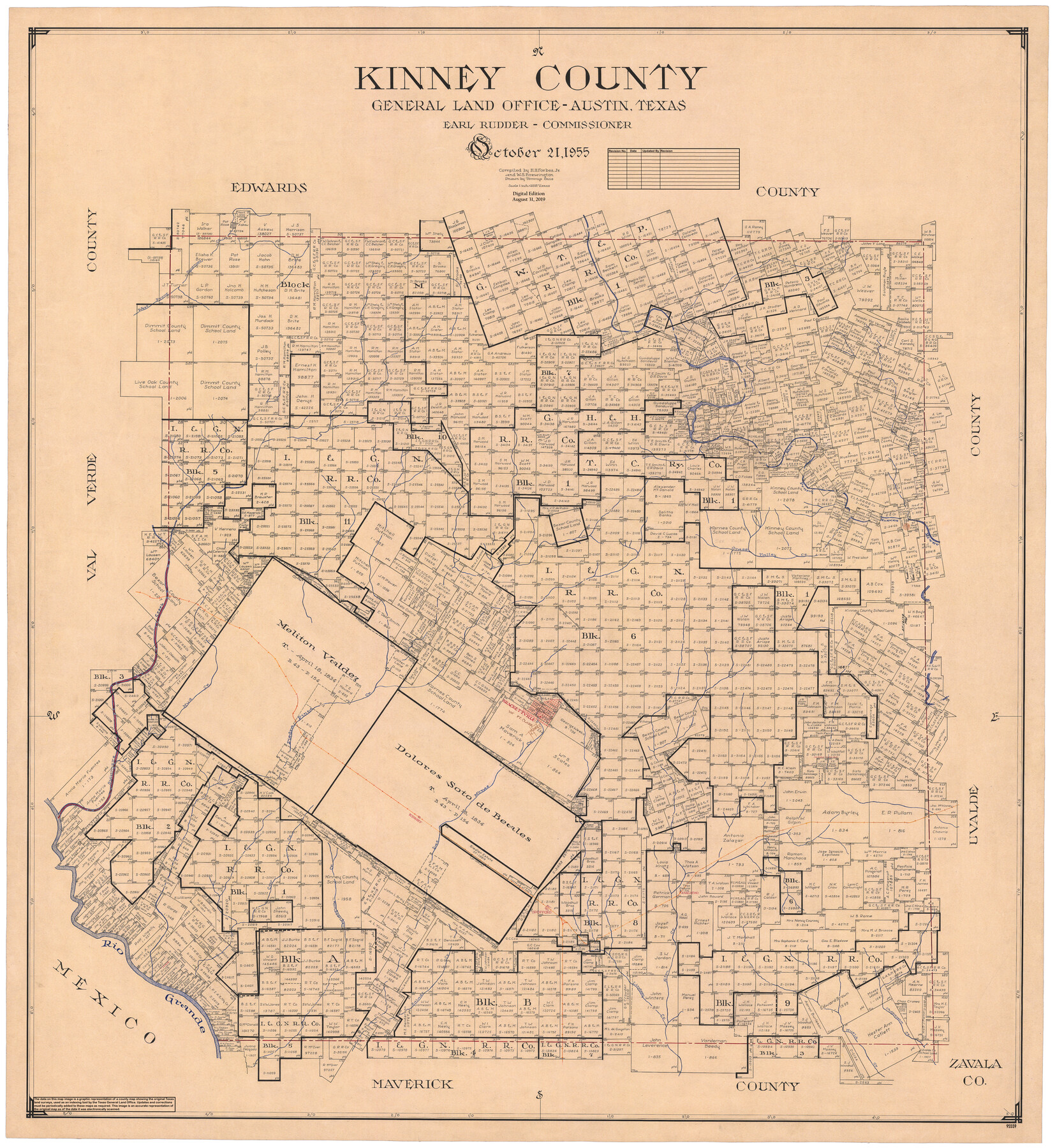
Kinney County
General Land Office Official County Map
-
Map/Doc
95559
-
Collection
General Map Collection
-
Object Dates
2019/8/31 (Revision Date)
1955/10/21 (Creation Date)
-
People and Organizations
Cheyenne Betancourt (Draftsman)
Tommye Buie (Draftsman)
H.H. Forbes, Jr. (Compiler)
W. S. Brewington (Compiler)
Earl Rudder (GLO Commissioner)
-
Counties
Kinney
-
Subjects
County OCM
-
Height x Width
51.9 x 48.2 inches
131.8 x 122.4 cm
-
Medium
digital image
-
Scale
1" = 2000 varas
Part of: General Map Collection

Kimble County Working Sketch 57

Print $20.00
- Digital $50.00
Kimble County Working Sketch 57
1958
Size 20.3 x 30.5 inches
Map/Doc 70125
County Map of Texas and Indian Territory

Print $20.00
- Digital $50.00
County Map of Texas and Indian Territory
1881
Size 13.1 x 9.9 inches
Map/Doc 94153
Dallas County Boundary File 6a

Print $36.00
- Digital $50.00
Dallas County Boundary File 6a
Size 14.0 x 8.6 inches
Map/Doc 52189
Brazoria County Sketch File 44

Print $30.00
- Digital $50.00
Brazoria County Sketch File 44
1946
Size 11.3 x 8.9 inches
Map/Doc 15068
Township 11 North Range 15 West, Western District, Louisiana

Print $20.00
- Digital $50.00
Township 11 North Range 15 West, Western District, Louisiana
1834
Size 19.7 x 24.6 inches
Map/Doc 65870
Map of Surveys made in Fisher and Miller's Colony

Print $40.00
- Digital $50.00
Map of Surveys made in Fisher and Miller's Colony
1848
Size 48.4 x 57.7 inches
Map/Doc 16830
Henderson County Sketch File 11

Print $2.00
- Digital $50.00
Henderson County Sketch File 11
Size 8.5 x 3.7 inches
Map/Doc 26348
Denton County Working Sketch 27

Print $20.00
- Digital $50.00
Denton County Working Sketch 27
1996
Size 41.3 x 35.3 inches
Map/Doc 68632

Flight Mission No. CGI-1N, Frame 138, Cameron County

Print $20.00
- Digital $50.00
Flight Mission No. CGI-1N, Frame 138, Cameron County
1955
Size 15.5 x 18.7 inches
Map/Doc 84494
Harris County Historic Topographic 3

Print $20.00
- Digital $50.00
Harris County Historic Topographic 3
1916
Size 29.4 x 22.5 inches
Map/Doc 65813
You may also like
Presidio County Working Sketch 31

Print $20.00
- Digital $50.00
Presidio County Working Sketch 31
1946
Size 25.2 x 26.3 inches
Map/Doc 71708
Township 6 North Range 14 West, North Western District, Louisiana

Print $20.00
- Digital $50.00
Township 6 North Range 14 West, North Western District, Louisiana
1841
Size 19.5 x 24.7 inches
Map/Doc 65863
Ector County Sketch File 9

Print $5.00
- Digital $50.00
Ector County Sketch File 9
1939
Size 28.7 x 22.2 inches
Map/Doc 11418
Mills County Sketch File 4a

Print $3.00
- Digital $50.00
Mills County Sketch File 4a
1874
Size 14.5 x 10.1 inches
Map/Doc 31651
PSL Field Notes for Blocks A27 and A28 in Andrews and Gaines Counties, and Blocks A6 through A13, A20 through A26, and A30 in Gaines County

PSL Field Notes for Blocks A27 and A28 in Andrews and Gaines Counties, and Blocks A6 through A13, A20 through A26, and A30 in Gaines County
Map/Doc 81654
Blanco County Sketch File 33

Print $4.00
- Digital $50.00
Blanco County Sketch File 33
Size 7.9 x 7.0 inches
Map/Doc 14635
Hutchinson County Rolled Sketch 43

Print $40.00
- Digital $50.00
Hutchinson County Rolled Sketch 43
1992
Size 40.5 x 49.4 inches
Map/Doc 6312
Johnson's Military Map of the United States showing the Forts, Military Posts & all the Military Divisions with enlarged plans of southern harbors

Print $20.00
- Digital $50.00
Johnson's Military Map of the United States showing the Forts, Military Posts & all the Military Divisions with enlarged plans of southern harbors
1861
Map/Doc 93947
Jeff Davis County Sketch File 4

Print $42.00
- Digital $50.00
Jeff Davis County Sketch File 4
1889
Size 12.5 x 14.7 inches
Map/Doc 27893
Galveston County NRC Article 33.136 Sketch 44

Print $22.00
- Digital $50.00
Galveston County NRC Article 33.136 Sketch 44
2007
Size 36.6 x 24.6 inches
Map/Doc 88352
Flight Mission No. DQN-7K, Frame 88, Calhoun County

Print $20.00
- Digital $50.00
Flight Mission No. DQN-7K, Frame 88, Calhoun County
1953
Size 18.5 x 22.1 inches
Map/Doc 84479
Flight Mission No. CRC-4R, Frame 63, Chambers County

Print $20.00
- Digital $50.00
Flight Mission No. CRC-4R, Frame 63, Chambers County
1956
Size 18.7 x 22.4 inches
Map/Doc 84867