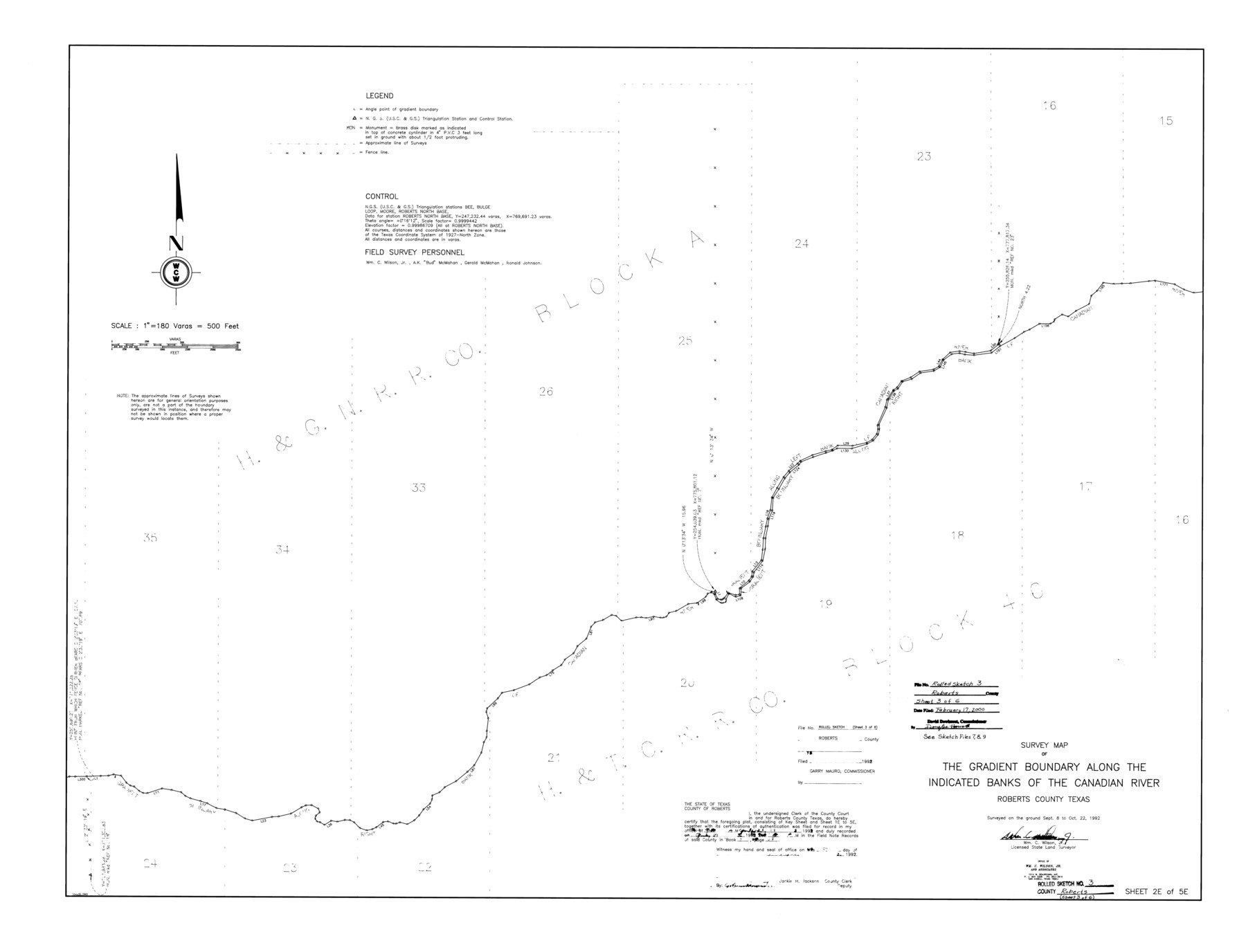
Roberts County Rolled Sketch 3
Survey map of the gradient boundary along the indicated banks of the Canadian River, Roberts County, Texas
-
Map/Doc
8356
-
Collection
General Map Collection
-
Object Dates
1992/10/22 (Survey Date)
2000/2/17 (File Date)
-
People and Organizations
Wm. C. Wilson, Jr. (Surveyor/Engineer)
-
Counties
Roberts
-
Subjects
Surveying Rolled Sketch
-
Height x Width
38.0 x 49.7 inches
96.5 x 126.2 cm
-
Medium
mylar, print
-
Scale
1" = 180 varas
-
Comments
One of six sheets. For all sheets see Roberts County Rolled Sketch 3 (8354-8359). Also see Roberts County Sketch File 7 (35316), Roberts County Sketch File 8 (35324), and Roberts County Sketch File 9 (35327) for field notes.
Related maps
Roberts County Sketch File 7

Print $16.00
- Digital $50.00
Roberts County Sketch File 7
1992
Size 14.3 x 8.8 inches
Map/Doc 35316
Roberts County Sketch File 8

Print $6.00
- Digital $50.00
Roberts County Sketch File 8
1992
Size 14.3 x 8.8 inches
Map/Doc 35324
Roberts County Sketch File 9

Print $26.00
- Digital $50.00
Roberts County Sketch File 9
1992
Size 14.3 x 9.0 inches
Map/Doc 35327
Roberts County Rolled Sketch 3

Print $40.00
- Digital $50.00
Roberts County Rolled Sketch 3
Size 38.0 x 49.7 inches
Map/Doc 8354
Roberts County Rolled Sketch 3

Print $40.00
- Digital $50.00
Roberts County Rolled Sketch 3
Size 38.0 x 49.7 inches
Map/Doc 8355
Roberts County Rolled Sketch 3

Print $40.00
- Digital $50.00
Roberts County Rolled Sketch 3
Size 38.0 x 49.7 inches
Map/Doc 8357
Roberts County Rolled Sketch 3

Print $40.00
- Digital $50.00
Roberts County Rolled Sketch 3
Size 38.4 x 50.0 inches
Map/Doc 8358
Roberts County Rolled Sketch 3

Print $40.00
- Digital $50.00
Roberts County Rolled Sketch 3
Size 37.7 x 48.9 inches
Map/Doc 8359
Part of: General Map Collection
Trinity County

Print $20.00
- Digital $50.00
Trinity County
1857
Size 19.2 x 30.8 inches
Map/Doc 4094
Map of Williamson County

Print $20.00
- Digital $50.00
Map of Williamson County
1876
Size 21.2 x 28.6 inches
Map/Doc 4152
Flight Mission No. DQO-2K, Frame 84, Galveston County

Print $20.00
- Digital $50.00
Flight Mission No. DQO-2K, Frame 84, Galveston County
1952
Size 18.8 x 22.5 inches
Map/Doc 85011
Flight Mission No. DCL-7C, Frame 19, Kenedy County

Print $20.00
- Digital $50.00
Flight Mission No. DCL-7C, Frame 19, Kenedy County
1943
Size 15.4 x 15.2 inches
Map/Doc 86011
Hemphill County Working Sketch 4

Print $20.00
- Digital $50.00
Hemphill County Working Sketch 4
1940
Size 31.6 x 41.6 inches
Map/Doc 66099
Grayson County Sketch File 6

Print $8.00
- Digital $50.00
Grayson County Sketch File 6
Size 12.9 x 8.2 inches
Map/Doc 24466
Ward County State of Texas

Print $20.00
- Digital $50.00
Ward County State of Texas
1888
Size 22.6 x 26.0 inches
Map/Doc 4641
Flight Mission No. BRA-3M, Frame 191, Jefferson County

Print $20.00
- Digital $50.00
Flight Mission No. BRA-3M, Frame 191, Jefferson County
1953
Size 18.6 x 22.3 inches
Map/Doc 85406
Runnels County Rolled Sketch 34

Print $20.00
- Digital $50.00
Runnels County Rolled Sketch 34
Size 30.1 x 35.1 inches
Map/Doc 7522
West Half of Sabine Lake, Jefferson County, showing Subdivision for Mineral Development; do not use; see Map 25a

Print $20.00
- Digital $50.00
West Half of Sabine Lake, Jefferson County, showing Subdivision for Mineral Development; do not use; see Map 25a
1956
Size 38.2 x 28.4 inches
Map/Doc 1930
Burnet County Working Sketch 7

Print $20.00
- Digital $50.00
Burnet County Working Sketch 7
1960
Size 17.9 x 20.3 inches
Map/Doc 67850
Flight Mission No. DAH-17M, Frame 20, Orange County

Print $20.00
- Digital $50.00
Flight Mission No. DAH-17M, Frame 20, Orange County
1953
Size 18.6 x 22.6 inches
Map/Doc 86883
You may also like
Runnels County Working Sketch 24

Print $20.00
- Digital $50.00
Runnels County Working Sketch 24
1952
Size 30.6 x 20.0 inches
Map/Doc 63620
Flight Mission No. BQY-15M, Frame 12, Harris County

Print $20.00
- Digital $50.00
Flight Mission No. BQY-15M, Frame 12, Harris County
1953
Size 18.7 x 22.4 inches
Map/Doc 85310
Montgomery County Working Sketch 17

Print $20.00
- Digital $50.00
Montgomery County Working Sketch 17
1934
Size 39.0 x 36.9 inches
Map/Doc 71124
Copy of connection with surveys of Bl. D, GH&SA Ry. Co. in Kimble County

Print $6.00
- Digital $50.00
Copy of connection with surveys of Bl. D, GH&SA Ry. Co. in Kimble County
1890
Size 14.2 x 8.9 inches
Map/Doc 89457
[Blks. Z, C4, 194, 178, C3, A2, 179 and 207]
![89837, [Blks. Z, C4, 194, 178, C3, A2, 179 and 207], Twichell Survey Records](https://historictexasmaps.com/wmedia_w700/maps/89837-1.tif.jpg)
Print $40.00
- Digital $50.00
[Blks. Z, C4, 194, 178, C3, A2, 179 and 207]
Size 61.6 x 37.5 inches
Map/Doc 89837
[Surveys along the Leon River]
![82093, [Surveys along the Leon River], General Map Collection](https://historictexasmaps.com/wmedia_w700/maps/82093.tif.jpg)
Print $20.00
- Digital $50.00
[Surveys along the Leon River]
1840
Size 20.5 x 6.7 inches
Map/Doc 82093
Plat Compiled by W. J. Williams, Plainview, Texas, and Sylvan Sanders, Lubbock, Texas Showing Position of Original and Re-Survey Corners in Lynn, Terry, Yoakum, Gaines and Dawson Counties, Texas

Print $40.00
- Digital $50.00
Plat Compiled by W. J. Williams, Plainview, Texas, and Sylvan Sanders, Lubbock, Texas Showing Position of Original and Re-Survey Corners in Lynn, Terry, Yoakum, Gaines and Dawson Counties, Texas
1946
Size 57.6 x 22.9 inches
Map/Doc 89689
Edwards County Working Sketch 123

Print $20.00
- Digital $50.00
Edwards County Working Sketch 123
1976
Size 18.3 x 25.2 inches
Map/Doc 68999
Hutchinson County Rolled Sketch 38

Print $40.00
- Digital $50.00
Hutchinson County Rolled Sketch 38
1955
Size 43.6 x 67.7 inches
Map/Doc 9248
Nacogdoches County Rolled Sketch 1

Print $20.00
- Digital $50.00
Nacogdoches County Rolled Sketch 1
1950
Size 33.5 x 31.0 inches
Map/Doc 6836
Dimmit County Sketch File 15

Print $20.00
- Digital $50.00
Dimmit County Sketch File 15
1883
Size 18.1 x 31.4 inches
Map/Doc 11343
Hockley County Rolled Sketch 8

Print $20.00
- Digital $50.00
Hockley County Rolled Sketch 8
1946
Size 25.1 x 38.0 inches
Map/Doc 6217