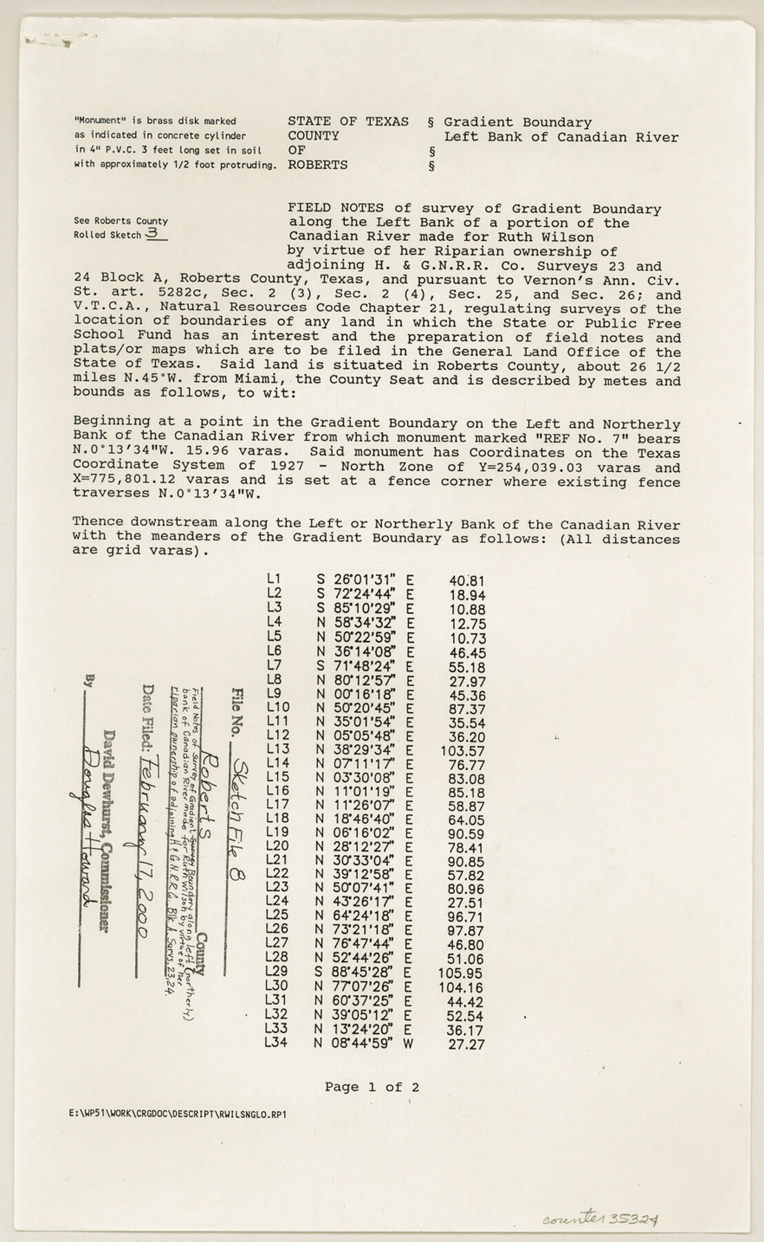
Roberts County Sketch File 8
[Field notes of survey of gradient boundary along the left bank of a portion of the Canadian River made for Ruth Wilson by virtue of her riparian ownership of adjoining H. & G. N. R.R. Co. surveys 23 and 24, Block A]
-
Map/Doc
35324
-
Collection
General Map Collection
-
Object Dates
1992 (Creation Date)
2/17/2000 (File Date)
Sept. 8 - Oct. 22/1992 (Survey Date)
-
People and Organizations
Wm. C. Wilson, Jr. (Surveyor/Engineer)
A.K. "Bud" McMahan (Chainman/Field Personnel)
Gerald McMahan (Chainman/Field Personnel)
Ronald Johnson (Chainman/Field Personnel)
-
Counties
Roberts
-
Subjects
Surveying Sketch File
-
Height x Width
14.3 x 8.8 inches
36.3 x 22.4 cm
-
Medium
paper, print
-
Comments
See Roberts County Rolled Sketch 3 (8354-8359).
-
Features
Canadian River
Related maps
Roberts County Rolled Sketch 3

Print $40.00
- Digital $50.00
Roberts County Rolled Sketch 3
Size 38.0 x 49.7 inches
Map/Doc 8354
Roberts County Rolled Sketch 3

Print $40.00
- Digital $50.00
Roberts County Rolled Sketch 3
Size 38.0 x 49.7 inches
Map/Doc 8355
Roberts County Rolled Sketch 3

Print $40.00
- Digital $50.00
Roberts County Rolled Sketch 3
Size 38.0 x 49.7 inches
Map/Doc 8356
Roberts County Rolled Sketch 3

Print $40.00
- Digital $50.00
Roberts County Rolled Sketch 3
Size 38.0 x 49.7 inches
Map/Doc 8357
Roberts County Rolled Sketch 3

Print $40.00
- Digital $50.00
Roberts County Rolled Sketch 3
Size 38.4 x 50.0 inches
Map/Doc 8358
Roberts County Rolled Sketch 3

Print $40.00
- Digital $50.00
Roberts County Rolled Sketch 3
Size 37.7 x 48.9 inches
Map/Doc 8359
Part of: General Map Collection
Sabine Pass and Lake

Print $20.00
- Digital $50.00
Sabine Pass and Lake
1971
Size 47.0 x 27.5 inches
Map/Doc 69825
Clay County Sketch File 31

Print $4.00
- Digital $50.00
Clay County Sketch File 31
Size 10.2 x 8.0 inches
Map/Doc 18456
Map of Floyd County

Print $20.00
- Digital $50.00
Map of Floyd County
1888
Size 25.4 x 19.6 inches
Map/Doc 3547
Liberty County Working Sketch 50

Print $20.00
- Digital $50.00
Liberty County Working Sketch 50
1955
Size 22.4 x 33.5 inches
Map/Doc 70510
Nolan County Sketch File 10

Print $6.00
- Digital $50.00
Nolan County Sketch File 10
1902
Size 14.2 x 9.0 inches
Map/Doc 32484
Bowie County Sketch File 7

Print $40.00
- Digital $50.00
Bowie County Sketch File 7
1927
Size 18.0 x 35.5 inches
Map/Doc 10943
Dickens County Sketch File 6a

Print $6.00
- Digital $50.00
Dickens County Sketch File 6a
1882
Size 16.5 x 9.4 inches
Map/Doc 20969
Austin County Rolled Sketch 7

Print $47.00
- Digital $50.00
Austin County Rolled Sketch 7
1974
Size 10.4 x 15.3 inches
Map/Doc 42340
Morris County Rolled Sketch 2A

Print $20.00
- Digital $50.00
Morris County Rolled Sketch 2A
Size 24.3 x 19.1 inches
Map/Doc 10239
Brazos River, Koy Bridge Sheet/Mill Creek

Print $20.00
- Digital $50.00
Brazos River, Koy Bridge Sheet/Mill Creek
1933
Size 44.0 x 27.3 inches
Map/Doc 65290
Edwards County Working Sketch 137, revised

Print $20.00
- Digital $50.00
Edwards County Working Sketch 137, revised
1997
Size 33.6 x 35.1 inches
Map/Doc 69014
Jasper County Working Sketch 11

Print $20.00
- Digital $50.00
Jasper County Working Sketch 11
1917
Size 20.2 x 23.4 inches
Map/Doc 66473
You may also like
Coryell County Working Sketch 20

Print $20.00
- Digital $50.00
Coryell County Working Sketch 20
1972
Size 32.2 x 22.4 inches
Map/Doc 68227
Map of Portland, Texas in San Patricio County

Print $20.00
- Digital $50.00
Map of Portland, Texas in San Patricio County
Size 39.8 x 46.0 inches
Map/Doc 48886
Map of Nacogdoches County

Print $20.00
- Digital $50.00
Map of Nacogdoches County
1881
Size 24.1 x 21.5 inches
Map/Doc 4605
"Capture of Cynthia Ann Parker"

Print $20.00
"Capture of Cynthia Ann Parker"
Size 20.0 x 16.0 inches
Map/Doc 94150
Flight Mission No. BRA-9M, Frame 64, Jefferson County

Print $20.00
- Digital $50.00
Flight Mission No. BRA-9M, Frame 64, Jefferson County
1953
Size 18.6 x 22.4 inches
Map/Doc 85647
[Surveys in Southeast part of Stephens County]
![91909, [Surveys in Southeast part of Stephens County], Twichell Survey Records](https://historictexasmaps.com/wmedia_w700/maps/91909-1.tif.jpg)
Print $2.00
- Digital $50.00
[Surveys in Southeast part of Stephens County]
Size 9.1 x 7.0 inches
Map/Doc 91909
Harris County Historic Topographic 9

Print $20.00
- Digital $50.00
Harris County Historic Topographic 9
1916
Size 14.6 x 24.0 inches
Map/Doc 65819
Anderson County Working Sketch 12

Print $20.00
- Digital $50.00
Anderson County Working Sketch 12
1914
Size 15.1 x 12.4 inches
Map/Doc 67012
Stonewall County Working Sketch 14

Print $20.00
- Digital $50.00
Stonewall County Working Sketch 14
1951
Size 22.2 x 37.1 inches
Map/Doc 62321
Brewster County Rolled Sketch 98

Print $20.00
- Digital $50.00
Brewster County Rolled Sketch 98
1952
Size 29.3 x 38.0 inches
Map/Doc 8508
Matagorda County Working Sketch 6

Print $20.00
- Digital $50.00
Matagorda County Working Sketch 6
1950
Size 24.2 x 41.5 inches
Map/Doc 70864
Denton County Working Sketch 28

Print $20.00
- Digital $50.00
Denton County Working Sketch 28
1995
Size 36.1 x 22.9 inches
Map/Doc 68633