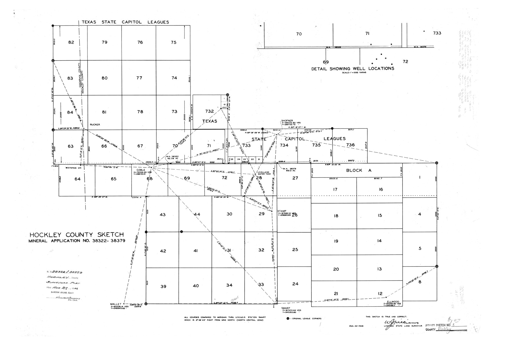
Hockley County Rolled Sketch 8
Hockley County Sketch - Mineral Application No. 38322-38379
-
Map/Doc
6217
-
Collection
General Map Collection
-
Object Dates
1946/8/22 (Creation Date)
1946/8/27 (File Date)
-
People and Organizations
W.J. Williams (Surveyor/Engineer)
-
Counties
Hockley
-
Subjects
Surveying Rolled Sketch
-
Height x Width
25.1 x 38.0 inches
63.8 x 96.5 cm
Part of: General Map Collection
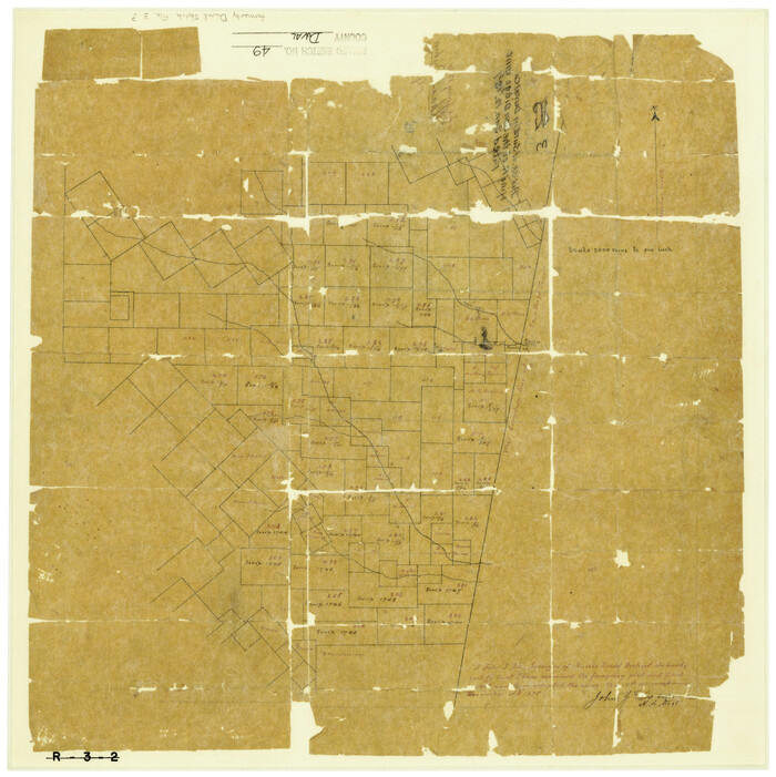
Duval County Rolled Sketch 49
Print $20.00
- Digital $50.00
Duval County Rolled Sketch 49
1875
Size 17.8 x 17.6 inches
Map/Doc 5763
[Surveys in the Jefferson District on the Sabine River]
![325, [Surveys in the Jefferson District on the Sabine River], General Map Collection](https://historictexasmaps.com/wmedia_w700/maps/325.tif.jpg)
Print $2.00
- Digital $50.00
[Surveys in the Jefferson District on the Sabine River]
1841
Size 8.7 x 7.8 inches
Map/Doc 325
Culberson County Sketch File 7

Print $8.00
- Digital $50.00
Culberson County Sketch File 7
1888
Size 14.5 x 8.8 inches
Map/Doc 20138
Flight Mission No. DIX-6P, Frame 111, Aransas County

Print $20.00
- Digital $50.00
Flight Mission No. DIX-6P, Frame 111, Aransas County
1956
Size 18.9 x 22.6 inches
Map/Doc 83817
[Location, Fort Worth & Denver Railroad, through Wilbarger County]
![64344, [Location, Fort Worth & Denver Railroad, through Wilbarger County], General Map Collection](https://historictexasmaps.com/wmedia_w700/maps/64344.tif.jpg)
Print $40.00
- Digital $50.00
[Location, Fort Worth & Denver Railroad, through Wilbarger County]
Size 20.8 x 123.5 inches
Map/Doc 64344
Map of Winkler County

Print $20.00
- Digital $50.00
Map of Winkler County
1901
Size 43.1 x 36.6 inches
Map/Doc 4158
Upton County Sketch File 29

Print $40.00
- Digital $50.00
Upton County Sketch File 29
1935
Size 16.9 x 14.4 inches
Map/Doc 38881
Mitchell County Sketch File 6

Print $40.00
- Digital $50.00
Mitchell County Sketch File 6
Size 12.4 x 13.5 inches
Map/Doc 31692
Real County Working Sketch 88

Print $20.00
- Digital $50.00
Real County Working Sketch 88
1989
Size 23.9 x 27.0 inches
Map/Doc 71980
Crockett County Rolled Sketch 88N

Print $89.00
- Digital $50.00
Crockett County Rolled Sketch 88N
1973
Size 10.6 x 15.5 inches
Map/Doc 44132
Gaines County

Print $40.00
- Digital $50.00
Gaines County
1902
Size 38.9 x 49.7 inches
Map/Doc 66832
Flight Mission No. BRA-7M, Frame 139, Jefferson County

Print $20.00
- Digital $50.00
Flight Mission No. BRA-7M, Frame 139, Jefferson County
1953
Size 18.7 x 22.4 inches
Map/Doc 85533
You may also like
Presidio County Rolled Sketch S1

Print $20.00
- Digital $50.00
Presidio County Rolled Sketch S1
Size 13.3 x 18.8 inches
Map/Doc 7414
State of Texas showing the Lower Rio Grande Valley

Print $20.00
- Digital $50.00
State of Texas showing the Lower Rio Grande Valley
1920
Size 14.0 x 13.4 inches
Map/Doc 95802
Briscoe County Sketch File 2a

Print $4.00
- Digital $50.00
Briscoe County Sketch File 2a
Size 6.2 x 7.1 inches
Map/Doc 16415
La Salle County Working Sketch 33

Print $20.00
- Digital $50.00
La Salle County Working Sketch 33
1956
Size 33.0 x 38.3 inches
Map/Doc 70334
Aransas County Rolled Sketch 31

Print $20.00
- Digital $50.00
Aransas County Rolled Sketch 31
1986
Size 30.0 x 41.4 inches
Map/Doc 77498
Plat Showing Block Z, W. D. and F. W. Johnson Subdivision, Bailey County, Texas

Print $20.00
- Digital $50.00
Plat Showing Block Z, W. D. and F. W. Johnson Subdivision, Bailey County, Texas
1955
Size 24.3 x 15.7 inches
Map/Doc 92538
[R. M. Thompson Blk. T]
![90409, [R. M. Thompson Blk. T], Twichell Survey Records](https://historictexasmaps.com/wmedia_w700/maps/90409-1.tif.jpg)
Print $20.00
- Digital $50.00
[R. M. Thompson Blk. T]
Size 16.6 x 21.7 inches
Map/Doc 90409
Map of The Surveyed Part of Peters Colony Texas

Print $40.00
- Digital $50.00
Map of The Surveyed Part of Peters Colony Texas
1858
Size 45.0 x 58.1 inches
Map/Doc 4653
Preliminary Chart of Entrance to Brazos River, Texas

Print $20.00
- Digital $50.00
Preliminary Chart of Entrance to Brazos River, Texas
1858
Size 18.4 x 19.5 inches
Map/Doc 69973
Flight Mission No. CGI-1N, Frame 218, Cameron County

Print $20.00
- Digital $50.00
Flight Mission No. CGI-1N, Frame 218, Cameron County
1955
Size 18.6 x 22.1 inches
Map/Doc 84527
Flight Mission No. CUG-1P, Frame 103, Kleberg County

Print $20.00
- Digital $50.00
Flight Mission No. CUG-1P, Frame 103, Kleberg County
1956
Size 18.5 x 22.6 inches
Map/Doc 86153
Pecos County Working Sketch 64

Print $20.00
- Digital $50.00
Pecos County Working Sketch 64
1955
Size 27.7 x 43.4 inches
Map/Doc 71536