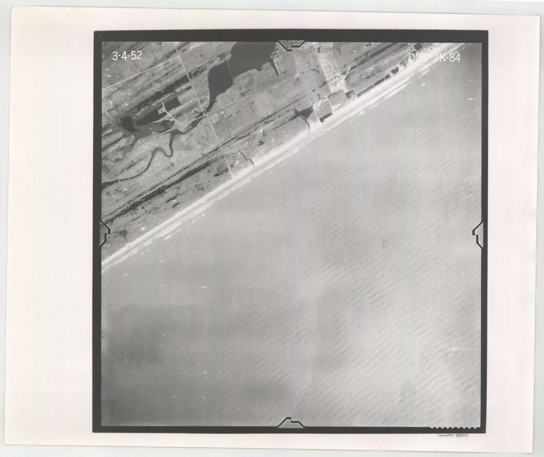
Flight Mission No. DQO-2K, Frame 84, Galveston County
DQO-2K-84
-
Map/Doc
85011
-
Collection
General Map Collection
-
Object Dates
1952/3/4 (Creation Date)
-
People and Organizations
U. S. Department of Agriculture (Publisher)
-
Counties
Galveston
-
Subjects
Aerial Photograph
-
Height x Width
18.8 x 22.5 inches
47.8 x 57.2 cm
-
Comments
Flown by Aero Exploration Company of Tulsa, Oklahoma.
Part of: General Map Collection
Mills County Working Sketch 18

Print $20.00
- Digital $50.00
Mills County Working Sketch 18
1963
Size 23.2 x 37.0 inches
Map/Doc 71048
Wilbarger County Sketch File 3

Print $26.00
- Digital $50.00
Wilbarger County Sketch File 3
Size 7.4 x 13.9 inches
Map/Doc 40166
Bastrop County Boundary File 4

Print $48.00
- Digital $50.00
Bastrop County Boundary File 4
1925
Size 11.2 x 8.7 inches
Map/Doc 50324
Presidio County Sketch File 87

Print $6.00
- Digital $50.00
Presidio County Sketch File 87
1951
Size 14.5 x 8.7 inches
Map/Doc 34748
Culberson County Working Sketch 26

Print $20.00
- Digital $50.00
Culberson County Working Sketch 26
1951
Size 42.7 x 28.3 inches
Map/Doc 68479

Tom Green County Sketch File 89

Print $4.00
Tom Green County Sketch File 89
Size 14.3 x 8.9 inches
Map/Doc 97245
Orange County Rolled Sketch 25

Print $20.00
- Digital $50.00
Orange County Rolled Sketch 25
1951
Size 29.0 x 43.5 inches
Map/Doc 10723
Wichita County Rolled Sketch 19

Print $20.00
- Digital $50.00
Wichita County Rolled Sketch 19
1963
Size 28.5 x 30.9 inches
Map/Doc 8255
Val Verde Co.

Print $20.00
- Digital $50.00
Val Verde Co.
1908
Size 39.1 x 37.7 inches
Map/Doc 63102
Lampasas County Boundary File 4

Print $44.00
- Digital $50.00
Lampasas County Boundary File 4
Size 14.0 x 8.5 inches
Map/Doc 56110
San Patricio County Rolled Sketch 34

Print $20.00
- Digital $50.00
San Patricio County Rolled Sketch 34
Size 25.8 x 26.2 inches
Map/Doc 7584
You may also like
[8 Ranch, Kent County, Texas]
![91032, [8 Ranch, Kent County, Texas], Twichell Survey Records](https://historictexasmaps.com/wmedia_w700/maps/91032-1.tif.jpg)
Print $20.00
- Digital $50.00
[8 Ranch, Kent County, Texas]
1946
Size 21.4 x 37.4 inches
Map/Doc 91032
Hudspeth County Rolled Sketch 30

Print $20.00
- Digital $50.00
Hudspeth County Rolled Sketch 30
1924
Size 36.0 x 47.3 inches
Map/Doc 9210

Kaufman County Working Sketch 9

Print $20.00
- Digital $50.00
Kaufman County Working Sketch 9
1988
Size 35.9 x 29.8 inches
Map/Doc 66672
Map of McClennan County

Print $20.00
- Digital $50.00
Map of McClennan County
1855
Size 22.7 x 24.7 inches
Map/Doc 3860
Angelina County Sketch File 18

Print $4.00
- Digital $50.00
Angelina County Sketch File 18
Size 8.6 x 3.9 inches
Map/Doc 13028
Flight Mission No. BQY-4M, Frame 61, Harris County

Print $20.00
- Digital $50.00
Flight Mission No. BQY-4M, Frame 61, Harris County
1953
Size 18.7 x 22.5 inches
Map/Doc 85270
[H. & T. C. RR. Company Block 47, Sections 46, 47, 48, and 49]
![91220, [H. & T. C. RR. Company Block 47, Sections 46, 47, 48, and 49], Twichell Survey Records](https://historictexasmaps.com/wmedia_w700/maps/91220-1.tif.jpg)
Print $3.00
- Digital $50.00
[H. & T. C. RR. Company Block 47, Sections 46, 47, 48, and 49]
Size 9.4 x 11.4 inches
Map/Doc 91220
Freestone County Working Sketch 5

Print $40.00
- Digital $50.00
Freestone County Working Sketch 5
Size 37.8 x 67.4 inches
Map/Doc 69247
Angelina County Sketch File 8

Print $22.00
- Digital $50.00
Angelina County Sketch File 8
1858
Size 8.0 x 3.5 inches
Map/Doc 12935
Newton County Working Sketch 37

Print $20.00
- Digital $50.00
Newton County Working Sketch 37
1960
Size 31.7 x 22.7 inches
Map/Doc 71283
[Township 4 North, Block 33]
![91216, [Township 4 North, Block 33], Twichell Survey Records](https://historictexasmaps.com/wmedia_w700/maps/91216-1.tif.jpg)
Print $3.00
- Digital $50.00
[Township 4 North, Block 33]
Size 11.3 x 12.0 inches
Map/Doc 91216