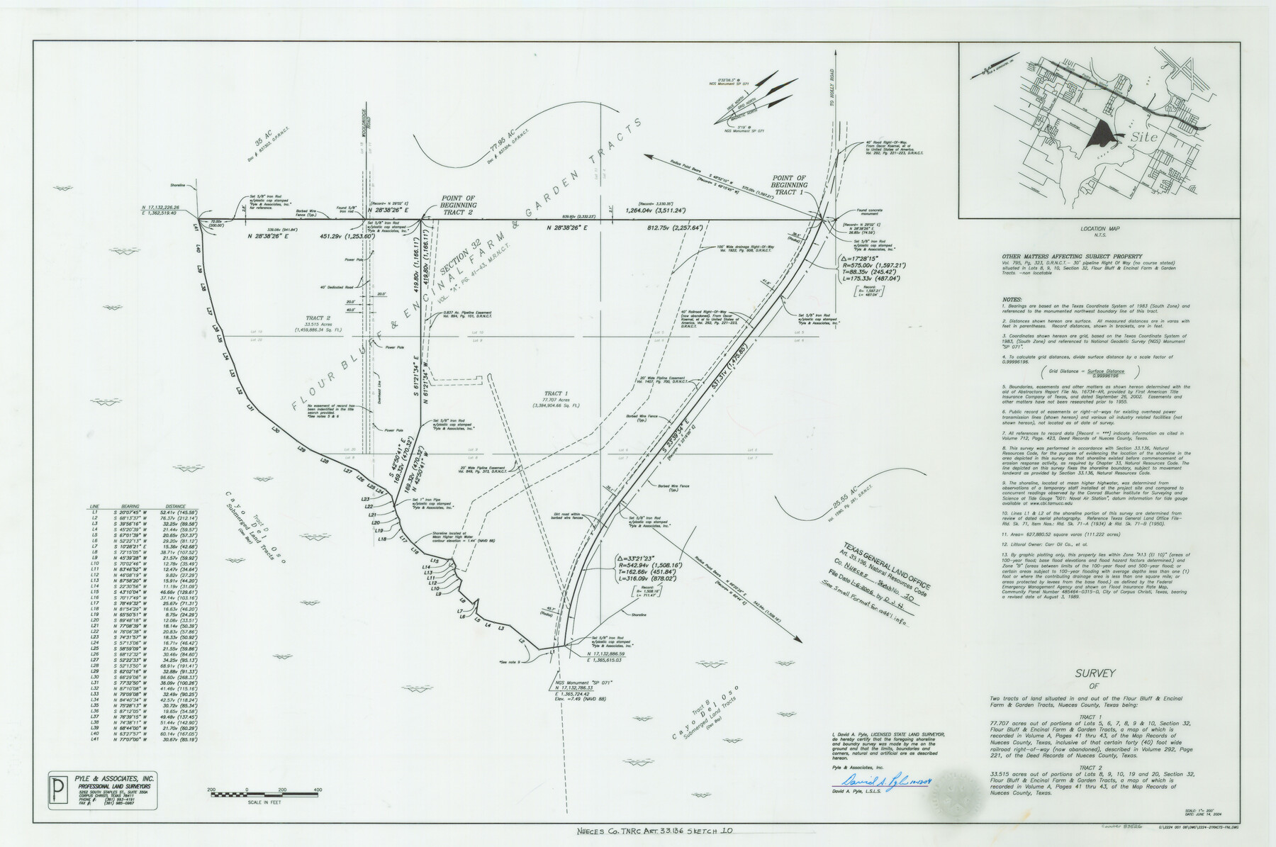
Nueces County NRC Article 33.136 Sketch 10
A Survey of two tracts of land situated in and out of the Flour Bluff and Encinal Farm and Garden Tracts, Section 32
-
Map/Doc
83526
-
Collection
General Map Collection
-
Object Dates
6/14/2004 (Creation Date)
1/6/2006 (File Date)
-
People and Organizations
David A. Pyle (Surveyor/Engineer)
-
Counties
Nueces
-
Subjects
Surveying CBS
-
Height x Width
23.9 x 35.9 inches
60.7 x 91.2 cm
-
Medium
multi-page, multi-format
-
Comments
Survey located about 10 miles South 26 degrees East of Corpus Christi, Texas.
Part of: General Map Collection

Dickens County Rolled Sketch N

Print $20.00
- Digital $50.00
Dickens County Rolled Sketch N
1909
Size 21.2 x 30.6 inches
Map/Doc 5714
Flight Mission No. BRA-16M, Frame 60, Jefferson County

Print $20.00
- Digital $50.00
Flight Mission No. BRA-16M, Frame 60, Jefferson County
1953
Size 18.6 x 22.3 inches
Map/Doc 85677
Flight Mission No. BRE-1P, Frame 98, Nueces County

Print $20.00
- Digital $50.00
Flight Mission No. BRE-1P, Frame 98, Nueces County
1956
Size 18.4 x 22.1 inches
Map/Doc 86669
Cherokee County Working Sketch 14

Print $40.00
- Digital $50.00
Cherokee County Working Sketch 14
1957
Size 44.9 x 61.1 inches
Map/Doc 67969
Trinity County Sketch File 18

Print $20.00
- Digital $50.00
Trinity County Sketch File 18
Size 21.9 x 20.7 inches
Map/Doc 12483
Red River Co.

Print $20.00
- Digital $50.00
Red River Co.
1897
Size 46.8 x 36.0 inches
Map/Doc 16796
Pecos County Sketch File 111

Print $18.00
- Digital $50.00
Pecos County Sketch File 111
Size 13.3 x 8.8 inches
Map/Doc 34052
Parker County Boundary File 3a

Print $34.00
- Digital $50.00
Parker County Boundary File 3a
Size 11.2 x 8.8 inches
Map/Doc 57840
Padre Island National Seashore

Print $4.00
- Digital $50.00
Padre Island National Seashore
Size 16.2 x 22.2 inches
Map/Doc 60533
Brown County Working Sketch 20

Print $20.00
- Digital $50.00
Brown County Working Sketch 20
2011
Size 32.8 x 34.8 inches
Map/Doc 89999
Flight Mission No. DQN-2K, Frame 44, Calhoun County

Print $20.00
- Digital $50.00
Flight Mission No. DQN-2K, Frame 44, Calhoun County
1953
Size 18.4 x 22.1 inches
Map/Doc 84249
You may also like
Map of Young County

Print $20.00
- Digital $50.00
Map of Young County
1896
Size 41.6 x 35.0 inches
Map/Doc 4172
Flight Mission No. DQO-1K, Frame 92, Galveston County

Print $20.00
- Digital $50.00
Flight Mission No. DQO-1K, Frame 92, Galveston County
1952
Size 18.9 x 22.6 inches
Map/Doc 84988
El Paso County Sketch File 4

Print $20.00
- Digital $50.00
El Paso County Sketch File 4
1885
Size 17.1 x 28.3 inches
Map/Doc 11449
Kent County Rolled Sketch 8

Print $20.00
- Digital $50.00
Kent County Rolled Sketch 8
1873
Size 31.5 x 35.5 inches
Map/Doc 9344
Johnson County Rolled Sketch 2

Print $20.00
- Digital $50.00
Johnson County Rolled Sketch 2
1956
Size 20.6 x 22.3 inches
Map/Doc 6447
Baylor County, Texas

Print $20.00
- Digital $50.00
Baylor County, Texas
Size 21.7 x 18.9 inches
Map/Doc 525
Hays County Boundary File

Print $120.00
- Digital $50.00
Hays County Boundary File
1947
Size 33.6 x 20.8 inches
Map/Doc 65496
Hamilton County Boundary File 5

Print $35.00
- Digital $50.00
Hamilton County Boundary File 5
Size 11.1 x 8.6 inches
Map/Doc 54217
Carson County Rolled Sketch 1

Print $20.00
- Digital $50.00
Carson County Rolled Sketch 1
Size 31.2 x 33.4 inches
Map/Doc 8580
Map of Jefferson as owned by Allen Urquhart

Print $20.00
- Digital $50.00
Map of Jefferson as owned by Allen Urquhart
1850
Size 25.1 x 16.6 inches
Map/Doc 1684
Old Miscellaneous File 15

Print $12.00
- Digital $50.00
Old Miscellaneous File 15
1905
Size 11.0 x 7.8 inches
Map/Doc 75451
La Salle County Rolled Sketch 15

Print $20.00
- Digital $50.00
La Salle County Rolled Sketch 15
Size 22.0 x 32.4 inches
Map/Doc 6579