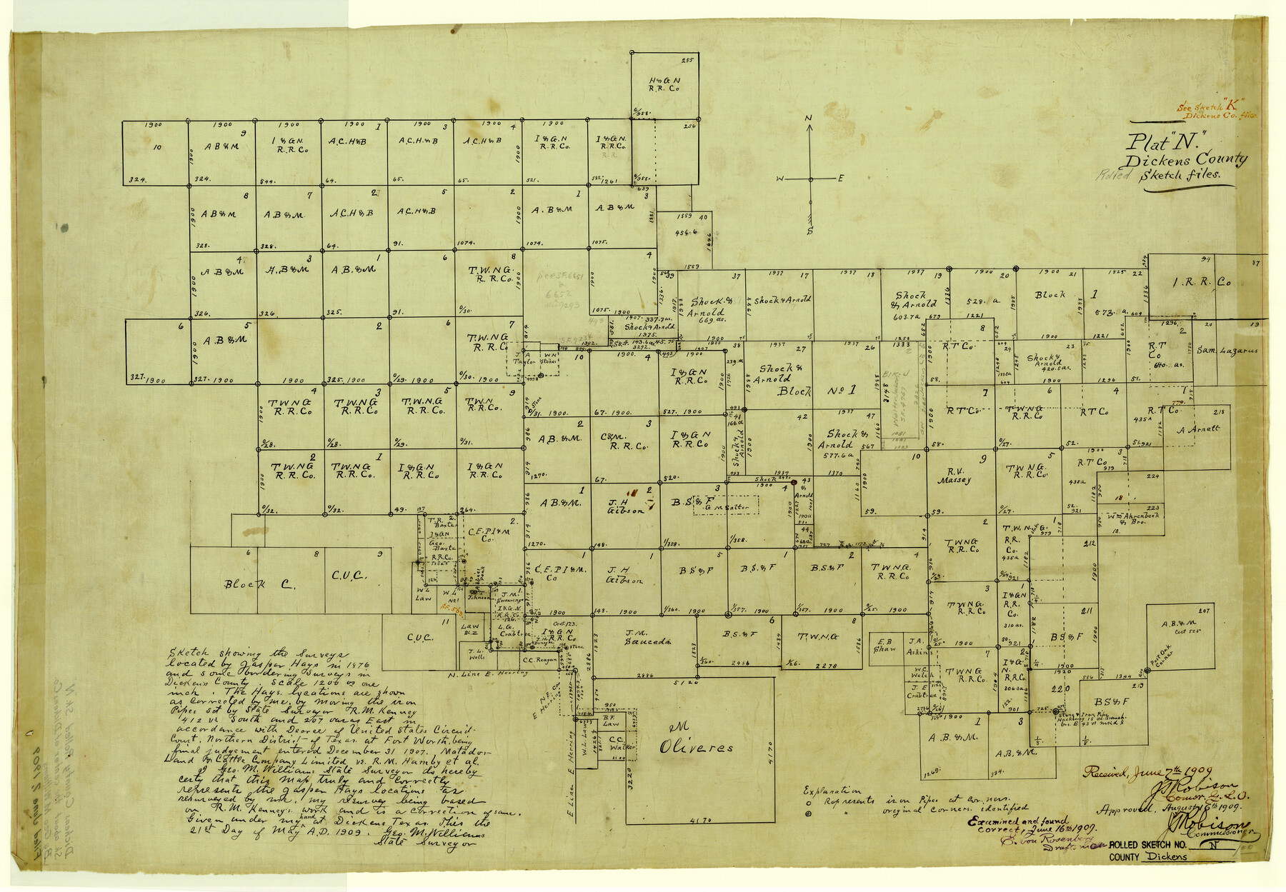
Dickens County Rolled Sketch N
Sketch showing the surveys located by Jasper Hays in 1876 and some bordering surveys in Dickens County
-
Map/Doc
5714
-
Collection
General Map Collection
-
Object Dates
1909/5/21 (Creation Date)
1909/6/7 (File Date)
-
People and Organizations
Geo. M. Williams (Surveyor/Engineer)
-
Counties
Dickens
-
Subjects
Surveying Rolled Sketch
-
Height x Width
21.2 x 30.6 inches
53.8 x 77.7 cm
-
Medium
linen, manuscript
Part of: General Map Collection
Trinity River, Kimbrough Lake Sheet

Print $4.00
- Digital $50.00
Trinity River, Kimbrough Lake Sheet
1929
Size 26.0 x 19.4 inches
Map/Doc 65225
Intracoastal Waterway in Texas - Corpus Christi to Point Isabel including Arroyo Colorado to Mo. Pac. R.R. Bridge Near Harlingen

Print $20.00
- Digital $50.00
Intracoastal Waterway in Texas - Corpus Christi to Point Isabel including Arroyo Colorado to Mo. Pac. R.R. Bridge Near Harlingen
1934
Size 21.8 x 32.6 inches
Map/Doc 61888
Midland County Working Sketch 16

Print $40.00
- Digital $50.00
Midland County Working Sketch 16
1953
Size 61.7 x 32.6 inches
Map/Doc 70996
Brewster County Sketch File N-24

Print $40.00
- Digital $50.00
Brewster County Sketch File N-24
Size 23.9 x 16.4 inches
Map/Doc 10970
Erath County Sketch File 35

Print $8.00
- Digital $50.00
Erath County Sketch File 35
1992
Size 14.5 x 8.8 inches
Map/Doc 22326
[Surveys in Austin's Colony along the east bank of the Navidad River]
![78488, [Surveys in Austin's Colony along the east bank of the Navidad River], General Map Collection](https://historictexasmaps.com/wmedia_w700/maps/78488.tif.jpg)
Print $20.00
- Digital $50.00
[Surveys in Austin's Colony along the east bank of the Navidad River]
1827
Size 20.3 x 16.1 inches
Map/Doc 78488
Flight Mission No. BRA-7M, Frame 82, Jefferson County

Print $20.00
- Digital $50.00
Flight Mission No. BRA-7M, Frame 82, Jefferson County
1953
Size 16.1 x 15.9 inches
Map/Doc 85504
Concho County Sketch File 44

Print $6.00
- Digital $50.00
Concho County Sketch File 44
1952
Size 14.3 x 8.8 inches
Map/Doc 19207

Clay County Boundary File 16

Print $56.00
- Digital $50.00
Clay County Boundary File 16
Size 9.1 x 3.7 inches
Map/Doc 51422
Refugio County Working Sketch 11

Print $20.00
- Digital $50.00
Refugio County Working Sketch 11
1942
Size 40.9 x 38.3 inches
Map/Doc 63520
Garza County Sketch File 20

Print $20.00
- Digital $50.00
Garza County Sketch File 20
1905
Size 8.7 x 7.8 inches
Map/Doc 24068
You may also like
Jefferson County Aerial Photograph Index Sheet 6

Print $20.00
- Digital $50.00
Jefferson County Aerial Photograph Index Sheet 6
1953
Size 23.3 x 17.0 inches
Map/Doc 83710
[Sections 94 and 826-831 along Red River]
![93161, [Sections 94 and 826-831 along Red River], Twichell Survey Records](https://historictexasmaps.com/wmedia_w700/maps/93161-1.tif.jpg)
Print $40.00
- Digital $50.00
[Sections 94 and 826-831 along Red River]
Size 43.2 x 111.4 inches
Map/Doc 93161
Knox County, Texas

Print $20.00
- Digital $50.00
Knox County, Texas
1880
Size 27.7 x 23.4 inches
Map/Doc 550
Montgomery County Rolled Sketch 22

Print $40.00
- Digital $50.00
Montgomery County Rolled Sketch 22
1934
Size 38.0 x 61.7 inches
Map/Doc 9532
Uvalde County Working Sketch 31

Print $20.00
- Digital $50.00
Uvalde County Working Sketch 31
1962
Size 28.5 x 43.0 inches
Map/Doc 72101
Kenedy County Rolled Sketch 11

Print $20.00
- Digital $50.00
Kenedy County Rolled Sketch 11
1938
Size 40.5 x 30.2 inches
Map/Doc 6471
[Sketch of sections 33 and 34]
![91574, [Sketch of sections 33 and 34], Twichell Survey Records](https://historictexasmaps.com/wmedia_w700/maps/91574-1.tif.jpg)
Print $2.00
- Digital $50.00
[Sketch of sections 33 and 34]
Size 5.1 x 8.8 inches
Map/Doc 91574
La Salle County Working Sketch 49

Print $20.00
- Digital $50.00
La Salle County Working Sketch 49
1984
Size 31.7 x 29.0 inches
Map/Doc 70350
Grayson County Sketch File 16

Print $6.00
- Digital $50.00
Grayson County Sketch File 16
Size 11.3 x 8.4 inches
Map/Doc 24484
A Map of Louisiana and Mexico

Print $20.00
- Digital $50.00
A Map of Louisiana and Mexico
1820
Size 43.8 x 32.9 inches
Map/Doc 94945
San Augustine County Rolled Sketch 1

Print $20.00
- Digital $50.00
San Augustine County Rolled Sketch 1
Size 16.6 x 13.8 inches
Map/Doc 7552
McMullen County Working Sketch 11

Print $20.00
- Digital $50.00
McMullen County Working Sketch 11
1938
Size 26.8 x 31.6 inches
Map/Doc 70712