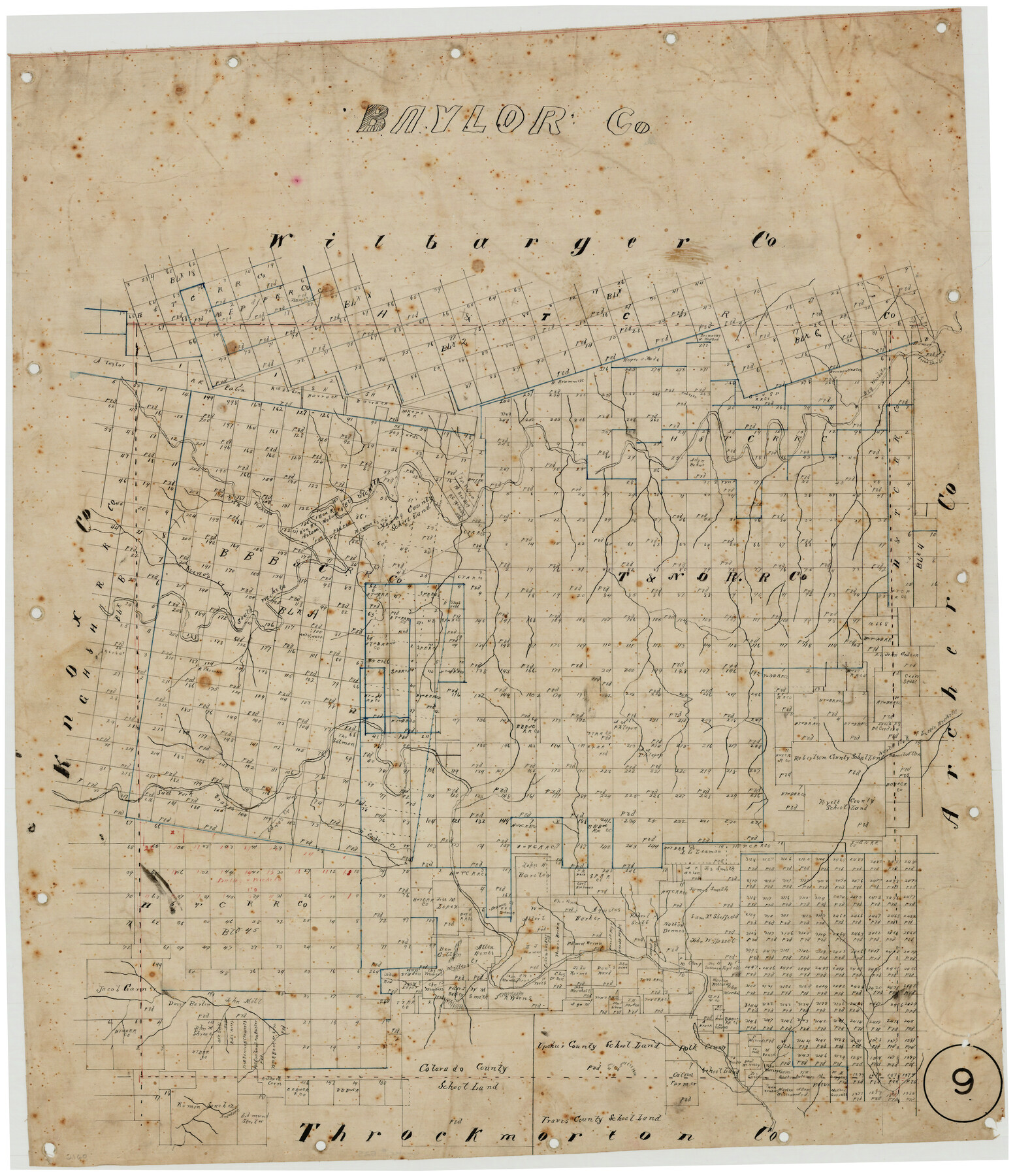
Baylor County, Texas
-
Map/Doc
525
-
Collection
Maddox Collection
-
Counties
Baylor
-
Subjects
County
-
Height x Width
21.7 x 18.9 inches
55.1 x 48.0 cm
-
Medium
linen, manuscript
-
Comments
Conservation funded by Friends of the Texas General Land Office in 2011.
-
Features
Horse Shoe Lake
Big Wichita [River]
North Wichita River
Newport River
South Wichita River
Kiowas Creek
North Fork of Wichita River
Cache Creek
Edna's Creek
South Fork of Brazos [River]
Millers Creek
Antelope Creek
Part of: Maddox Collection
Map of Menard County

Print $20.00
- Digital $50.00
Map of Menard County
1898
Size 19.9 x 43.1 inches
Map/Doc 5042
Map of surveys 191 & 192 T. C. R.R. Co. in Travis County, Texas

Print $20.00
- Digital $50.00
Map of surveys 191 & 192 T. C. R.R. Co. in Travis County, Texas
1915
Size 20.6 x 13.6 inches
Map/Doc 75554
Sketch of part of the NW part, Hutchinson County

Print $20.00
- Digital $50.00
Sketch of part of the NW part, Hutchinson County
1909
Size 20.9 x 31.2 inches
Map/Doc 75816
Roberts County, Texas

Print $20.00
- Digital $50.00
Roberts County, Texas
1878
Size 19.2 x 18.5 inches
Map/Doc 749
Collin County, Texas

Print $20.00
- Digital $50.00
Collin County, Texas
1879
Size 19.6 x 17.0 inches
Map/Doc 559
Map showing Center Lines on Holley St.

Print $3.00
- Digital $50.00
Map showing Center Lines on Holley St.
1912
Size 6.1 x 17.5 inches
Map/Doc 495
Castro County, Texas

Print $20.00
- Digital $50.00
Castro County, Texas
1883
Size 20.8 x 18.7 inches
Map/Doc 682
Red River County, Texas

Print $20.00
- Digital $50.00
Red River County, Texas
1879
Size 29.3 x 21.9 inches
Map/Doc 598
Plat of 92 Surveys Containing 51,365 acres on the Main Brazos River, Texas ,Young Land District

Print $20.00
- Digital $50.00
Plat of 92 Surveys Containing 51,365 acres on the Main Brazos River, Texas ,Young Land District
1857
Size 23.4 x 31.0 inches
Map/Doc 551
Collingsworth County, Texas

Print $20.00
- Digital $50.00
Collingsworth County, Texas
Size 18.3 x 16.6 inches
Map/Doc 465
Austin, Texas - Congress Ave. Drainage

Print $20.00
- Digital $50.00
Austin, Texas - Congress Ave. Drainage
1905
Size 15.8 x 31.2 inches
Map/Doc 458
Map of Kerr County, Texas

Print $20.00
- Digital $50.00
Map of Kerr County, Texas
1879
Size 21.7 x 28.5 inches
Map/Doc 526
You may also like

Hansford County Boundary File 3

Print $10.00
- Digital $50.00
Hansford County Boundary File 3
Size 13.6 x 8.7 inches
Map/Doc 54270
Map of Wilson County, Texas

Print $20.00
- Digital $50.00
Map of Wilson County, Texas
1879
Size 22.9 x 24.8 inches
Map/Doc 674
Flight Mission No. CRC-2R, Frame 194, Chambers County

Print $20.00
- Digital $50.00
Flight Mission No. CRC-2R, Frame 194, Chambers County
1956
Size 18.8 x 22.6 inches
Map/Doc 84772
[Surveys South of the Levi Jordan Title, Southwest of the Neches River]
![90424, [Surveys South of the Levi Jordan Title, Southwest of the Neches River], Twichell Survey Records](https://historictexasmaps.com/wmedia_w700/maps/90424-1.tif.jpg)
Print $20.00
- Digital $50.00
[Surveys South of the Levi Jordan Title, Southwest of the Neches River]
Size 33.4 x 43.3 inches
Map/Doc 90424
Hutchinson County

Print $20.00
- Digital $50.00
Hutchinson County
1898
Size 41.8 x 37.6 inches
Map/Doc 66875
Kenedy County Aerial Photograph Index Sheet 2

Print $20.00
- Digital $50.00
Kenedy County Aerial Photograph Index Sheet 2
1943
Size 23.1 x 19.3 inches
Map/Doc 83714
Flight Mission No. CUG-3P, Frame 94, Kleberg County

Print $20.00
- Digital $50.00
Flight Mission No. CUG-3P, Frame 94, Kleberg County
1956
Size 18.4 x 22.2 inches
Map/Doc 86264
Upton County Sketch File 38

Print $8.00
- Digital $50.00
Upton County Sketch File 38
1953
Size 11.1 x 8.9 inches
Map/Doc 38903
Medina County Rolled Sketch 7

Print $20.00
- Digital $50.00
Medina County Rolled Sketch 7
1966
Size 36.9 x 21.9 inches
Map/Doc 6741
Flight Mission No. DAG-21K, Frame 117, Matagorda County

Print $20.00
- Digital $50.00
Flight Mission No. DAG-21K, Frame 117, Matagorda County
1952
Size 18.5 x 22.4 inches
Map/Doc 86440
Irion County Boundary File 3

Print $38.00
- Digital $50.00
Irion County Boundary File 3
Size 8.8 x 4.2 inches
Map/Doc 55339