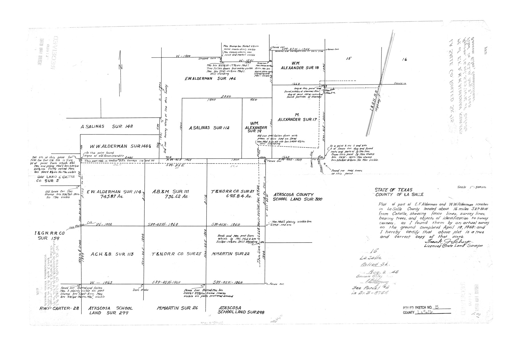
La Salle County Rolled Sketch 15
Plat of part of E.F. Alderman and W.W. Alderman ranches in La Salle County
-
Map/Doc
6579
-
Collection
General Map Collection
-
Object Dates
1948/4/19 (Survey Date)
1948/8/2 (File Date)
-
People and Organizations
Frank J. Schorp (Surveyor/Engineer)
-
Counties
La Salle
-
Subjects
Surveying Rolled Sketch
-
Height x Width
22.0 x 32.4 inches
55.9 x 82.3 cm
-
Scale
1" = 500 varas
Part of: General Map Collection
San Jacinto County Working Sketch 23

Print $40.00
- Digital $50.00
San Jacinto County Working Sketch 23
1940
Size 31.5 x 53.8 inches
Map/Doc 63736
Brewster County Rolled Sketch 114

Print $20.00
- Digital $50.00
Brewster County Rolled Sketch 114
1964
Size 11.7 x 18.4 inches
Map/Doc 5265
Crane County Rolled Sketch 26

Print $20.00
- Digital $50.00
Crane County Rolled Sketch 26
2020
Size 36.5 x 24.5 inches
Map/Doc 96432
Map Showing Resurvey of Capitol Leagues, Deaf Smith Co.

Print $20.00
- Digital $50.00
Map Showing Resurvey of Capitol Leagues, Deaf Smith Co.
1918
Size 42.5 x 31.9 inches
Map/Doc 1756
Brewster County Rolled Sketch 100

Print $133.00
- Digital $50.00
Brewster County Rolled Sketch 100
1893
Size 10.1 x 15.4 inches
Map/Doc 43055
Brazoria County Sketch File 47

Print $10.00
- Digital $50.00
Brazoria County Sketch File 47
Size 14.3 x 8.9 inches
Map/Doc 15106
Burnet County Working Sketch 23

Print $40.00
- Digital $50.00
Burnet County Working Sketch 23
1987
Size 43.8 x 51.9 inches
Map/Doc 67866
Atascosa County Working Sketch 30

Print $20.00
- Digital $50.00
Atascosa County Working Sketch 30
1980
Size 16.4 x 20.6 inches
Map/Doc 67226
Harris County Rolled Sketch P3

Print $20.00
- Digital $50.00
Harris County Rolled Sketch P3
1933
Size 13.9 x 20.0 inches
Map/Doc 6142
Harrison County Rolled Sketch 12

Print $20.00
- Digital $50.00
Harrison County Rolled Sketch 12
1960
Size 22.9 x 34.9 inches
Map/Doc 6155
Aransas County Sketch File 21

Print $2.00
- Digital $50.00
Aransas County Sketch File 21
Size 8.0 x 8.9 inches
Map/Doc 13157
Leon County Rolled Sketch 27A

Print $40.00
- Digital $50.00
Leon County Rolled Sketch 27A
Size 50.5 x 47.8 inches
Map/Doc 9437
You may also like
Fisher County Working Sketch 5

Print $20.00
- Digital $50.00
Fisher County Working Sketch 5
1926
Size 23.0 x 25.6 inches
Map/Doc 69139
[Surveys near the Guadalupe River]
![288, [Surveys near the Guadalupe River], General Map Collection](https://historictexasmaps.com/wmedia_w700/maps/288.tif.jpg)
Print $2.00
- Digital $50.00
[Surveys near the Guadalupe River]
1847
Size 8.8 x 7.9 inches
Map/Doc 288
Real County Rolled Sketch 3

Print $20.00
- Digital $50.00
Real County Rolled Sketch 3
1955
Size 14.6 x 23.3 inches
Map/Doc 7453

Travis County Sketch File 34

Print $26.00
- Digital $50.00
Travis County Sketch File 34
1888
Size 26.8 x 27.9 inches
Map/Doc 12461
[Sketch showing Block 42, Sections 221 and 222 and Block H, Sections 7 and 9]
![91714, [Sketch showing Block 42, Sections 221 and 222 and Block H, Sections 7 and 9], Twichell Survey Records](https://historictexasmaps.com/wmedia_w700/maps/91714-1.tif.jpg)
Print $2.00
- Digital $50.00
[Sketch showing Block 42, Sections 221 and 222 and Block H, Sections 7 and 9]
1919
Size 5.6 x 5.0 inches
Map/Doc 91714
Atascosa County Sketch File 27a

Print $4.00
- Digital $50.00
Atascosa County Sketch File 27a
Size 8.4 x 14.3 inches
Map/Doc 13799
Taylor County Rolled Sketch 27A

Print $20.00
- Digital $50.00
Taylor County Rolled Sketch 27A
Size 30.5 x 21.4 inches
Map/Doc 7919
Starr County Sketch File 19

Print $20.00
- Digital $50.00
Starr County Sketch File 19
1887
Size 22.6 x 22.0 inches
Map/Doc 12330
Flight Mission No. DQO-3K, Frame 22, Galveston County

Print $20.00
- Digital $50.00
Flight Mission No. DQO-3K, Frame 22, Galveston County
1952
Size 18.8 x 22.5 inches
Map/Doc 85063
Sketch in Terry, Yoakum, Dawson and Gaines Co's.

Print $40.00
- Digital $50.00
Sketch in Terry, Yoakum, Dawson and Gaines Co's.
1902
Size 72.8 x 26.4 inches
Map/Doc 89782
Bexar County Working Sketch 16

Print $20.00
- Digital $50.00
Bexar County Working Sketch 16
1978
Size 23.0 x 44.5 inches
Map/Doc 67332