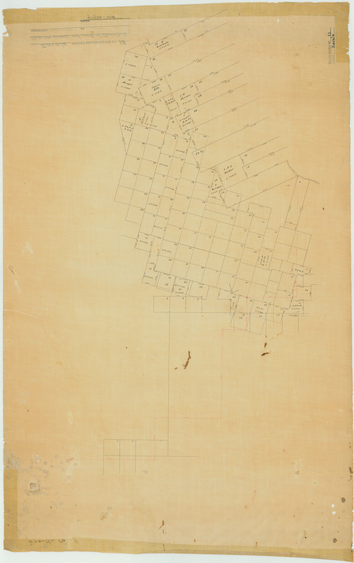
Zavala County Rolled Sketch 12
[Sketch of surveys to the west and south of Batesville]
-
Map/Doc
8320
-
Collection
General Map Collection
-
Counties
Zavala
-
Subjects
Surveying Rolled Sketch
-
Height x Width
33.4 x 21.0 inches
84.8 x 53.3 cm
-
Medium
linen, manuscript
Part of: General Map Collection
Jefferson County NRC Article 33.136 Sketch 3

Print $22.00
- Digital $50.00
Jefferson County NRC Article 33.136 Sketch 3
2003
Size 22.7 x 33.9 inches
Map/Doc 78610
Gonzales County Working Sketch 4a

Print $20.00
- Digital $50.00
Gonzales County Working Sketch 4a
1979
Size 30.9 x 32.2 inches
Map/Doc 63219
Cameron County Rolled Sketch Z9

Print $8.00
- Digital $50.00
Cameron County Rolled Sketch Z9
1847
Size 17.8 x 10.0 inches
Map/Doc 5407
San Saba County Working Sketch 3

Print $20.00
- Digital $50.00
San Saba County Working Sketch 3
1941
Size 27.3 x 20.7 inches
Map/Doc 63791
Goliad County Working Sketch 19

Print $20.00
- Digital $50.00
Goliad County Working Sketch 19
1954
Size 31.5 x 31.8 inches
Map/Doc 63209
Sketch showing surveys on Harbor Island in Nueces County

Print $20.00
- Digital $50.00
Sketch showing surveys on Harbor Island in Nueces County
1978
Size 46.4 x 36.0 inches
Map/Doc 2020
Kimble County Working Sketch 41

Print $20.00
- Digital $50.00
Kimble County Working Sketch 41
1948
Size 36.1 x 33.2 inches
Map/Doc 70109
Johnson County Boundary File 51

Print $66.00
- Digital $50.00
Johnson County Boundary File 51
Size 8.5 x 4.2 inches
Map/Doc 55589
Terrell County Working Sketch 35a

Print $20.00
- Digital $50.00
Terrell County Working Sketch 35a
1948
Size 26.4 x 45.1 inches
Map/Doc 62128
Texas Land Commissioner Jerry Patterson's Great Military Map of Texas showing Significant Conflicts and Events between 1685 and 1916

Print $20.00
- Digital $50.00
Texas Land Commissioner Jerry Patterson's Great Military Map of Texas showing Significant Conflicts and Events between 1685 and 1916
2006
Size 36.7 x 24.8 inches
Map/Doc 83432
Colorado River, Shoal Creek from 12th to 34th Street/Austin, Texas

Print $40.00
- Digital $50.00
Colorado River, Shoal Creek from 12th to 34th Street/Austin, Texas
1929
Size 61.5 x 28.6 inches
Map/Doc 65327
Beaumont, Sour Lake and Western Ry. Right of Way and Alignment - Frisco

Print $20.00
- Digital $50.00
Beaumont, Sour Lake and Western Ry. Right of Way and Alignment - Frisco
1910
Size 21.1 x 47.3 inches
Map/Doc 64105
You may also like
Flight Mission No. BRA-16M, Frame 113, Jefferson County

Print $20.00
- Digital $50.00
Flight Mission No. BRA-16M, Frame 113, Jefferson County
1953
Size 18.5 x 22.2 inches
Map/Doc 85723
Map showing survey for proposed ship channel from Brownsville to Brazos Santiago Pass

Print $20.00
- Digital $50.00
Map showing survey for proposed ship channel from Brownsville to Brazos Santiago Pass
1912
Size 18.1 x 28.0 inches
Map/Doc 72899
Flight Mission No. DCL-7C, Frame 46, Kenedy County

Print $20.00
- Digital $50.00
Flight Mission No. DCL-7C, Frame 46, Kenedy County
1943
Size 15.4 x 15.3 inches
Map/Doc 86034
Hardin County Sketch File 41 and 42

Print $8.00
- Digital $50.00
Hardin County Sketch File 41 and 42
Size 8.8 x 7.9 inches
Map/Doc 25188
Sheet 2 copied from Peck Book 6 [Strip Map showing T. & P. connecting lines]
![93172, Sheet 2 copied from Peck Book 6 [Strip Map showing T. & P. connecting lines], Twichell Survey Records](https://historictexasmaps.com/wmedia_w700/maps/93172-1.tif.jpg)
Print $40.00
- Digital $50.00
Sheet 2 copied from Peck Book 6 [Strip Map showing T. & P. connecting lines]
1909
Size 6.5 x 53.9 inches
Map/Doc 93172
Erath County Sketch File 26

Print $6.00
- Digital $50.00
Erath County Sketch File 26
1896
Size 9.5 x 8.1 inches
Map/Doc 22306
Jefferson County Sketch File 51

Print $10.00
- Digital $50.00
Jefferson County Sketch File 51
Size 10.0 x 6.7 inches
Map/Doc 28249
Flight Mission No. DQO-8K, Frame 44, Galveston County

Print $20.00
- Digital $50.00
Flight Mission No. DQO-8K, Frame 44, Galveston County
1952
Size 18.5 x 22.3 inches
Map/Doc 85151
Runnels County Rolled Sketch 34

Print $20.00
- Digital $50.00
Runnels County Rolled Sketch 34
1950
Size 30.8 x 35.5 inches
Map/Doc 7521
Brazoria County NRC Article 33.136 Sketch 24

Print $24.00
Brazoria County NRC Article 33.136 Sketch 24
2025
Map/Doc 97504
Map of The Surveyed Part of Peters Colony Texas

Print $40.00
- Digital $50.00
Map of The Surveyed Part of Peters Colony Texas
1858
Size 45.6 x 58.5 inches
Map/Doc 1982
Flight Mission No. DAG-24K, Frame 150, Matagorda County

Print $20.00
- Digital $50.00
Flight Mission No. DAG-24K, Frame 150, Matagorda County
1953
Size 18.5 x 22.2 inches
Map/Doc 86564