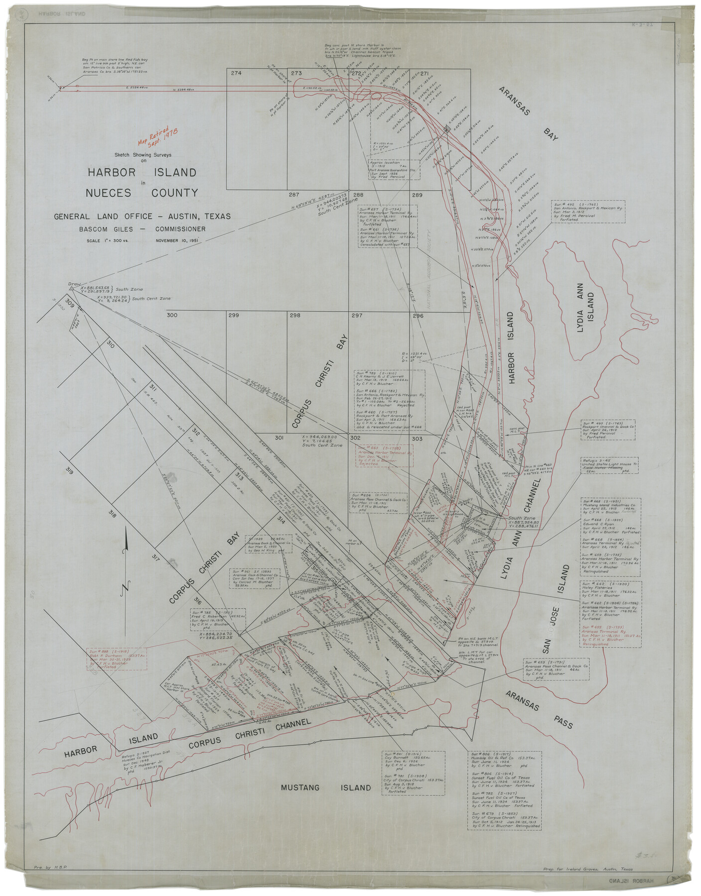
Sketch showing surveys on Harbor Island in Nueces County
K-3-57
-
Map/Doc
2020
-
Collection
General Map Collection
-
Object Dates
1978 (Creation Date)
-
People and Organizations
General Land Office (Publisher)
General Land Office (Author)
-
Counties
Nueces
-
Subjects
Energy Offshore Submerged Area
-
Height x Width
46.4 x 36.0 inches
117.9 x 91.4 cm
-
Comments
Map retired in Sept. 1978.
Part of: General Map Collection
Wichita County Rolled Sketch 19

Print $20.00
- Digital $50.00
Wichita County Rolled Sketch 19
1963
Size 28.5 x 30.9 inches
Map/Doc 8255
Flight Mission No. DQO-2K, Frame 165, Galveston County

Print $20.00
- Digital $50.00
Flight Mission No. DQO-2K, Frame 165, Galveston County
1952
Size 18.9 x 22.4 inches
Map/Doc 85054

[Old Coastal Chart showing Brazo Chico, Brazo de Santiago and Rio Bravo del Norte passes with depth readings]
![4661, [Old Coastal Chart showing Brazo Chico, Brazo de Santiago and Rio Bravo del Norte passes with depth readings], General Map Collection](https://historictexasmaps.com/wmedia_w700/maps/4661-1.tif.jpg)
Print $20.00
- Digital $50.00
[Old Coastal Chart showing Brazo Chico, Brazo de Santiago and Rio Bravo del Norte passes with depth readings]
1837
Size 25.7 x 39.3 inches
Map/Doc 4661
Medina County Boundary File 3

Print $8.00
- Digital $50.00
Medina County Boundary File 3
Size 11.2 x 8.7 inches
Map/Doc 57031
[Galveston, Harrisburg & San Antonio from El Paso to El Paso-Presidio county boundary]
![64719, [Galveston, Harrisburg & San Antonio from El Paso to El Paso-Presidio county boundary], General Map Collection](https://historictexasmaps.com/wmedia_w700/maps/64719.tif.jpg)
Print $40.00
- Digital $50.00
[Galveston, Harrisburg & San Antonio from El Paso to El Paso-Presidio county boundary]
Size 150.0 x 27.3 inches
Map/Doc 64719
Matagorda County Sketch File 41

Print $6.00
- Digital $50.00
Matagorda County Sketch File 41
Size 10.2 x 12.1 inches
Map/Doc 30832

Lynn County Rolled Sketch 10

Print $20.00
- Digital $50.00
Lynn County Rolled Sketch 10
Size 13.1 x 18.5 inches
Map/Doc 6646
Upton County Working Sketch Graphic Index, Sheet 1 (Sketches 1 to 39)

Print $40.00
- Digital $50.00
Upton County Working Sketch Graphic Index, Sheet 1 (Sketches 1 to 39)
1969
Size 49.9 x 37.0 inches
Map/Doc 76721
Presidio County Working Sketch 34

Print $20.00
- Digital $50.00
Presidio County Working Sketch 34
1947
Size 41.7 x 37.6 inches
Map/Doc 71711
Right of Way and Track Map, Galveston, Harrisburg & San Antonio Ry. operated by the T. & N. O. R.R. Co., Victoria Division, Rosenberg to Beeville

Print $40.00
- Digital $50.00
Right of Way and Track Map, Galveston, Harrisburg & San Antonio Ry. operated by the T. & N. O. R.R. Co., Victoria Division, Rosenberg to Beeville
1918
Size 24.4 x 57.9 inches
Map/Doc 76158
You may also like
[Leagues 67, 69, 70, 71, 72, 73, 75, 76, 719, 732, 733, 734, 735, 27, 28]
![90458, [Leagues 67, 69, 70, 71, 72, 73, 75, 76, 719, 732, 733, 734, 735, 27, 28], Twichell Survey Records](https://historictexasmaps.com/wmedia_w700/maps/90458-1.tif.jpg)
Print $20.00
- Digital $50.00
[Leagues 67, 69, 70, 71, 72, 73, 75, 76, 719, 732, 733, 734, 735, 27, 28]
Size 20.5 x 15.3 inches
Map/Doc 90458
La Salle County Sketch File 46

Print $20.00
- Digital $50.00
La Salle County Sketch File 46
Size 14.1 x 8.6 inches
Map/Doc 29603
Amistad International Reservoir on Rio Grande 102

Print $20.00
- Digital $50.00
Amistad International Reservoir on Rio Grande 102
1950
Size 28.5 x 41.2 inches
Map/Doc 75533
Hardeman County

Print $20.00
- Digital $50.00
Hardeman County
1935
Size 44.4 x 41.4 inches
Map/Doc 73170
San Jacinto County Working Sketch 35

Print $20.00
- Digital $50.00
San Jacinto County Working Sketch 35
1955
Size 31.3 x 32.1 inches
Map/Doc 63748
[Block Z and vicinity]
![91576, [Block Z and vicinity], Twichell Survey Records](https://historictexasmaps.com/wmedia_w700/maps/91576-1.tif.jpg)
Print $20.00
- Digital $50.00
[Block Z and vicinity]
1886
Size 32.4 x 11.6 inches
Map/Doc 91576
Flight Mission No. DQN-2K, Frame 29, Calhoun County

Print $20.00
- Digital $50.00
Flight Mission No. DQN-2K, Frame 29, Calhoun County
1953
Size 18.7 x 22.3 inches
Map/Doc 84236
Webb County Working Sketch 90

Print $20.00
- Digital $50.00
Webb County Working Sketch 90
1982
Size 26.9 x 25.5 inches
Map/Doc 72457
Atlantic Coast to the Rocky Mountains

Atlantic Coast to the Rocky Mountains
1956
Size 42.3 x 29.5 inches
Map/Doc 94410
Collin County Sketch File 12

Print $40.00
- Digital $50.00
Collin County Sketch File 12
1851
Size 24.3 x 31.3 inches
Map/Doc 11127
Potter County Boundary File 3a

Print $4.00
- Digital $50.00
Potter County Boundary File 3a
Size 11.2 x 8.7 inches
Map/Doc 57977
Young County Working Sketch 7

Print $20.00
- Digital $50.00
Young County Working Sketch 7
1919
Size 24.3 x 19.8 inches
Map/Doc 62030