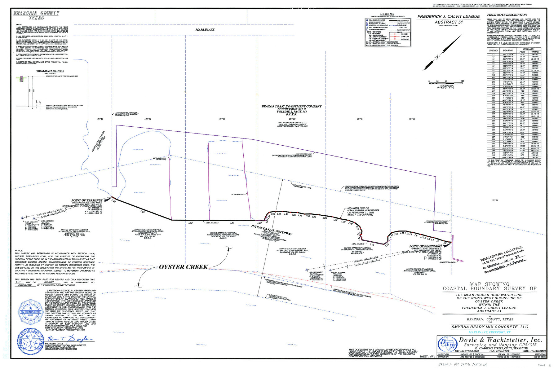
Brazoria County NRC Article 33.136 Sketch 24
Map showing coastal boundary survey of the mean higher high water line of the northwest shoreline of Oyster Creek within the Frederick J. Calvit League Abstract 51
-
Map/Doc
97504
-
Collection
General Map Collection
-
Object Dates
2/27/2025 (Creation Date)
9/16/2025 (File Date)
7/8/2025 (Revision Date)
2/21/2025 (Survey Date)
-
People and Organizations
Kim Thomas Doyle (Surveyor/Engineer)
-
Counties
Brazoria
-
Subjects
Surveying CBS
-
Comments
Project: Oyster Creek - I.C.W.W. - K. Doyle
Project No.: GLO LC20250006
Part of: General Map Collection
Harris County Aerial Photograph Index Sheet 10

Print $20.00
- Digital $50.00
Harris County Aerial Photograph Index Sheet 10
1953
Size 22.1 x 16.9 inches
Map/Doc 83704
Map of Kendall County

Print $20.00
- Digital $50.00
Map of Kendall County
1862
Size 21.0 x 20.0 inches
Map/Doc 3754
Runnels County Rolled Sketch 30

Print $20.00
- Digital $50.00
Runnels County Rolled Sketch 30
Size 26.8 x 30.6 inches
Map/Doc 7518
[Three-Marine League line stipulation as determined by US Supreme Court, October 1968 term; corrections to stipulation; Texas GLO approximations of county areas embraced by county boundaries, shoreline and 3-marine league line and 3-mile line]

Print $64.00
[Three-Marine League line stipulation as determined by US Supreme Court, October 1968 term; corrections to stipulation; Texas GLO approximations of county areas embraced by county boundaries, shoreline and 3-marine league line and 3-mile line]
1962
Size 13.4 x 8.7 inches
Map/Doc 61371
Texas Coordinate File 7

Print $4.00
- Digital $50.00
Texas Coordinate File 7
Size 11.3 x 8.8 inches
Map/Doc 75316
Atlas Pintoresco e Historico de los Estados Unidos Mexicanos

Atlas Pintoresco e Historico de los Estados Unidos Mexicanos
Map/Doc 96796
United States - Gulf Coast Texas - Northern part of Laguna Madre

Print $20.00
- Digital $50.00
United States - Gulf Coast Texas - Northern part of Laguna Madre
1923
Size 26.7 x 18.3 inches
Map/Doc 72932
Montgomery Co.

Print $40.00
- Digital $50.00
Montgomery Co.
1943
Size 44.0 x 52.4 inches
Map/Doc 77377
Harris County Historic Topographic 2

Print $20.00
- Digital $50.00
Harris County Historic Topographic 2
1916
Size 29.5 x 22.7 inches
Map/Doc 65812
Fisher County Rolled Sketch Y

Print $20.00
- Digital $50.00
Fisher County Rolled Sketch Y
Size 42.1 x 25.4 inches
Map/Doc 5878
Presidio County Sketch File 91

Print $40.00
- Digital $50.00
Presidio County Sketch File 91
Size 12.3 x 15.9 inches
Map/Doc 34763
Tarrant County Working Sketch 23

Print $20.00
- Digital $50.00
Tarrant County Working Sketch 23
2001
Size 15.9 x 15.6 inches
Map/Doc 62440
You may also like


El Paso County Working Sketch 43

Print $20.00
- Digital $50.00
El Paso County Working Sketch 43
Size 22.1 x 26.1 inches
Map/Doc 69065
Motley County Sketch File 36 (S)

Print $4.00
- Digital $50.00
Motley County Sketch File 36 (S)
1893
Size 11.0 x 8.8 inches
Map/Doc 32220
La Salle County Working Sketch 3

Print $20.00
- Digital $50.00
La Salle County Working Sketch 3
1914
Size 15.0 x 14.2 inches
Map/Doc 70304
Texas Official Highway Travel Map

Digital $50.00
Texas Official Highway Travel Map
Size 27.3 x 36.3 inches
Map/Doc 94306
Kenedy County Rolled Sketch 17

Print $40.00
- Digital $50.00
Kenedy County Rolled Sketch 17
1958
Size 96.6 x 28.5 inches
Map/Doc 10726
Brown County Sketch File 11a

Print $6.00
- Digital $50.00
Brown County Sketch File 11a
1872
Size 6.6 x 3.6 inches
Map/Doc 16599
Sectional Map of Pecos County, Texas

Print $20.00
- Digital $50.00
Sectional Map of Pecos County, Texas
1927
Size 36.5 x 46.4 inches
Map/Doc 89878
Stephens County Sketch File 25

Print $35.00
- Digital $50.00
Stephens County Sketch File 25
1875
Size 11.0 x 15.9 inches
Map/Doc 37090
The Republic County of Austin. February 1, 1844

Print $20.00
The Republic County of Austin. February 1, 1844
2020
Size 14.7 x 21.7 inches
Map/Doc 96087
Dimmit County Working Sketch 56

Print $20.00
- Digital $50.00
Dimmit County Working Sketch 56
1990
Size 23.0 x 29.0 inches
Map/Doc 68717