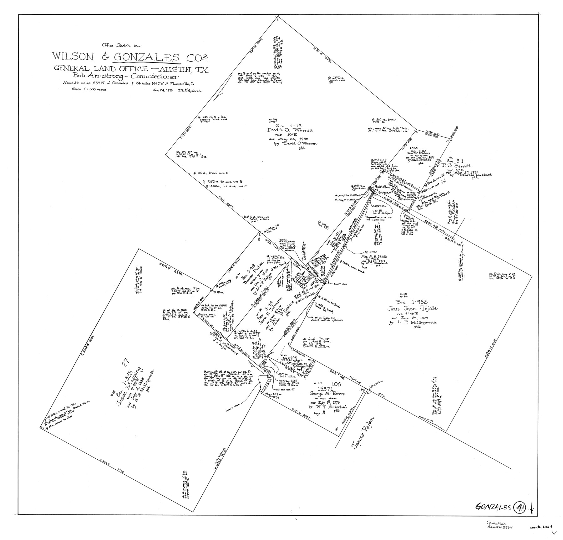
Gonzales County Working Sketch 4a
-
Map/Doc
63219
-
Collection
General Map Collection
-
Object Dates
1/24/1979 (Creation Date)
-
People and Organizations
Joan Kilpatrick (Draftsman)
-
Counties
Gonzales Wilson
-
Subjects
Surveying Working Sketch
-
Height x Width
30.9 x 32.2 inches
78.5 x 81.8 cm
-
Scale
1" = 500 varas
-
Comments
See Gonzales County Working Sketch 4b (63220) for companion sketch.
Related maps
Gonzales County Working Sketch 4b

Print $20.00
- Digital $50.00
Gonzales County Working Sketch 4b
1979
Size 21.2 x 27.3 inches
Map/Doc 63220
Part of: General Map Collection

Cottle County Sketch File KN

Print $20.00
- Digital $50.00
Cottle County Sketch File KN
Size 18.8 x 25.2 inches
Map/Doc 11203
Calhoun County Aerial Photograph Index Sheet 1

Print $20.00
- Digital $50.00
Calhoun County Aerial Photograph Index Sheet 1
1953
Size 23.7 x 19.7 inches
Map/Doc 83670
Map of Kyle, Lockhart & Southern Ry.

Print $40.00
- Digital $50.00
Map of Kyle, Lockhart & Southern Ry.
1882
Size 14.5 x 94.9 inches
Map/Doc 64285
Jeff Davis County Sketch File 46

Print $8.00
- Digital $50.00
Jeff Davis County Sketch File 46
1906
Size 13.5 x 8.8 inches
Map/Doc 28080
Webb County Sketch File LM3

Print $20.00
- Digital $50.00
Webb County Sketch File LM3
1924
Size 24.7 x 31.9 inches
Map/Doc 12658
Irion County Sketch File 15

Print $20.00
- Digital $50.00
Irion County Sketch File 15
1951
Size 21.3 x 24.1 inches
Map/Doc 11827
Irion County Rolled Sketch 6

Print $20.00
- Digital $50.00
Irion County Rolled Sketch 6
Size 23.6 x 39.9 inches
Map/Doc 6320
Flight Mission No. BRA-8M, Frame 78, Jefferson County

Print $20.00
- Digital $50.00
Flight Mission No. BRA-8M, Frame 78, Jefferson County
1953
Size 15.9 x 15.8 inches
Map/Doc 85598
Outer Continental Shelf Leasing Maps (Texas Offshore Operations)

Print $20.00
- Digital $50.00
Outer Continental Shelf Leasing Maps (Texas Offshore Operations)
Size 17.6 x 13.8 inches
Map/Doc 75844
Polk County Sketch File 1

Print $4.00
- Digital $50.00
Polk County Sketch File 1
Size 13.0 x 7.9 inches
Map/Doc 34116
Calhoun County Rolled Sketch 29C

Print $20.00
- Digital $50.00
Calhoun County Rolled Sketch 29C
1977
Size 22.0 x 24.0 inches
Map/Doc 8559
You may also like
[Sketch showing B. S. & F. Block 9]
![91743, [Sketch showing B. S. & F. Block 9], Twichell Survey Records](https://historictexasmaps.com/wmedia_w700/maps/91743-1.tif.jpg)
Print $20.00
- Digital $50.00
[Sketch showing B. S. & F. Block 9]
Size 25.1 x 34.1 inches
Map/Doc 91743
McCulloch County Sketch File 2

Print $4.00
- Digital $50.00
McCulloch County Sketch File 2
1872
Size 12.8 x 8.1 inches
Map/Doc 31167
Terrell County Working Sketch 79

Print $40.00
- Digital $50.00
Terrell County Working Sketch 79
1983
Size 43.0 x 55.8 inches
Map/Doc 69600
The Yellow Rose Compass

Price $20.00
The Yellow Rose Compass
2025
Size 3.5 x 2.8 inches
Map/Doc 97508
Map of W. D. Johnson's Pasture

Print $20.00
- Digital $50.00
Map of W. D. Johnson's Pasture
Size 25.1 x 15.0 inches
Map/Doc 90284
Liberty County Sketch File 5b

Print $6.00
- Digital $50.00
Liberty County Sketch File 5b
1857
Size 8.0 x 3.5 inches
Map/Doc 29890
Zavala County Sketch File A1

Print $31.00
- Digital $50.00
Zavala County Sketch File A1
1899
Size 23.5 x 28.6 inches
Map/Doc 12735
Map of San Gabriel & Lampassas [sic] Surveys
![58, Map of San Gabriel & Lampassas [sic] Surveys, General Map Collection](https://historictexasmaps.com/wmedia_w700/maps/58.tif.jpg)
Print $20.00
- Digital $50.00
Map of San Gabriel & Lampassas [sic] Surveys
1841
Size 29.0 x 20.0 inches
Map/Doc 58
Gregg County Working Sketch 8

Print $20.00
- Digital $50.00
Gregg County Working Sketch 8
1936
Size 26.0 x 23.3 inches
Map/Doc 63274
Bandera County Working Sketch 17

Print $20.00
- Digital $50.00
Bandera County Working Sketch 17
1943
Size 21.2 x 27.5 inches
Map/Doc 67613
[H. & G. N. Block 4]
![90268, [H. & G. N. Block 4], Twichell Survey Records](https://historictexasmaps.com/wmedia_w700/maps/90268-1.tif.jpg)
Print $20.00
- Digital $50.00
[H. & G. N. Block 4]
1887
Size 22.2 x 19.6 inches
Map/Doc 90268
The Rand-McNally New Commercial Atlas Map of Texas

Print $20.00
- Digital $50.00
The Rand-McNally New Commercial Atlas Map of Texas
Size 29.5 x 40.3 inches
Map/Doc 93993