Cameron County Rolled Sketch Z9
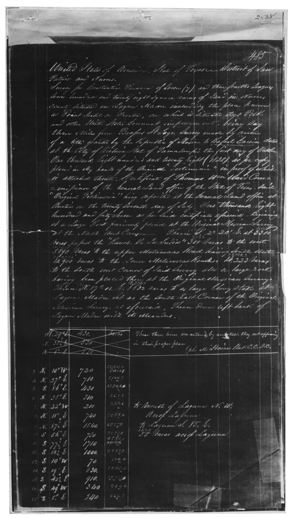
Copy of George Lyon field notes of Santa Isabel
Nueces County Rolled Sketch Z-4
-
Map/Doc
5407
-
Collection
General Map Collection
-
Object Dates
1847/12/18 (Creation Date)
1938/5/11 (File Date)
-
People and Organizations
George Lyon (Surveyor/Engineer)
-
Counties
Cameron
-
Subjects
Surveying Rolled Sketch
-
Height x Width
17.8 x 10.0 inches
45.2 x 25.4 cm
-
Medium
photostat
-
Comments
See Cameron County Rolled Sketch Z5 (5403) for sketch.
Related maps
Cameron County Rolled Sketch Z5

Print $20.00
- Digital $50.00
Cameron County Rolled Sketch Z5
1937
Size 28.7 x 33.6 inches
Map/Doc 5403
Part of: General Map Collection
Ellis County Sketch File 8

Print $40.00
- Digital $50.00
Ellis County Sketch File 8
1860
Size 12.8 x 16.2 inches
Map/Doc 21841
[Surveys in the Montgomery District: San Jacinto River and Caney Creek, Navidad, Navasota]
![33, [Surveys in the Montgomery District: San Jacinto River and Caney Creek, Navidad, Navasota], General Map Collection](https://historictexasmaps.com/wmedia_w700/maps/33.tif.jpg)
Print $2.00
- Digital $50.00
[Surveys in the Montgomery District: San Jacinto River and Caney Creek, Navidad, Navasota]
1846
Size 8.8 x 6.0 inches
Map/Doc 33
Aransas County Sketch File 29

Print $24.00
- Digital $50.00
Aransas County Sketch File 29
Size 7.8 x 8.1 inches
Map/Doc 13234
Pecos County Rolled Sketch 115A

Print $20.00
- Digital $50.00
Pecos County Rolled Sketch 115A
1943
Size 15.8 x 15.2 inches
Map/Doc 7258
Flight Mission No. BQR-5K, Frame 74, Brazoria County

Print $20.00
- Digital $50.00
Flight Mission No. BQR-5K, Frame 74, Brazoria County
1952
Size 18.8 x 22.4 inches
Map/Doc 84019
Brewster County Sketch File D-1

Print $12.00
- Digital $50.00
Brewster County Sketch File D-1
1909
Size 14.4 x 8.8 inches
Map/Doc 15740
Concho County Working Sketch 13

Print $20.00
- Digital $50.00
Concho County Working Sketch 13
1954
Size 26.3 x 14.1 inches
Map/Doc 68195
Colorado County Working Sketch 21

Print $20.00
- Digital $50.00
Colorado County Working Sketch 21
1963
Size 32.1 x 30.5 inches
Map/Doc 68121
Lampasas County Sketch File 18

Print $4.00
- Digital $50.00
Lampasas County Sketch File 18
Size 8.1 x 4.8 inches
Map/Doc 29430
Nueces County Sketch File 8

Print $22.00
- Digital $50.00
Nueces County Sketch File 8
1849
Size 8.2 x 12.4 inches
Map/Doc 32512
Chicago, Rock Island, Texas & Mexico

Print $20.00
- Digital $50.00
Chicago, Rock Island, Texas & Mexico
1920
Size 23.9 x 13.8 inches
Map/Doc 64423
Duval County Working Sketch 30

Print $20.00
- Digital $50.00
Duval County Working Sketch 30
1950
Size 29.1 x 33.5 inches
Map/Doc 68754
You may also like
T. & N. O. R.R. Jefferson Co. North

Print $20.00
- Digital $50.00
T. & N. O. R.R. Jefferson Co. North
1917
Size 13.4 x 33.5 inches
Map/Doc 64056
Liberty County Rolled Sketch OB-1

Print $40.00
- Digital $50.00
Liberty County Rolled Sketch OB-1
1934
Size 70.7 x 25.1 inches
Map/Doc 9564
Flight Mission No. CRC-2R, Frame 61, Chambers County

Print $20.00
- Digital $50.00
Flight Mission No. CRC-2R, Frame 61, Chambers County
1956
Size 18.8 x 22.5 inches
Map/Doc 84732
Maps of Gulf Intracoastal Waterway, Texas - Sabine River to the Rio Grande and connecting waterways including ship channels

Print $20.00
- Digital $50.00
Maps of Gulf Intracoastal Waterway, Texas - Sabine River to the Rio Grande and connecting waterways including ship channels
1966
Size 14.5 x 22.4 inches
Map/Doc 61918
Jefferson County Working Sketch 25

Print $20.00
- Digital $50.00
Jefferson County Working Sketch 25
1977
Size 39.8 x 43.4 inches
Map/Doc 66568
Burnet County Working Sketch 18

Print $20.00
- Digital $50.00
Burnet County Working Sketch 18
1980
Size 44.3 x 32.9 inches
Map/Doc 67861
Randall County Rolled Sketch 6

Print $20.00
- Digital $50.00
Randall County Rolled Sketch 6
Size 25.0 x 23.9 inches
Map/Doc 7426
[Sections 51-80 Block 47 and part of Block 3]
![91810, [Sections 51-80 Block 47 and part of Block 3], Twichell Survey Records](https://historictexasmaps.com/wmedia_w700/maps/91810-1.tif.jpg)
Print $20.00
- Digital $50.00
[Sections 51-80 Block 47 and part of Block 3]
Size 25.0 x 32.8 inches
Map/Doc 91810
Henderson County Working Sketch 24

Print $20.00
- Digital $50.00
Henderson County Working Sketch 24
1952
Size 29.3 x 22.9 inches
Map/Doc 66157
Map of Bexar County

Print $40.00
- Digital $50.00
Map of Bexar County
1887
Size 46.1 x 48.6 inches
Map/Doc 16942
Map of Jefferson County Texas

Print $20.00
- Digital $50.00
Map of Jefferson County Texas
1879
Size 23.3 x 20.6 inches
Map/Doc 3729
Glasscock County Rolled Sketch 2

Print $20.00
- Digital $50.00
Glasscock County Rolled Sketch 2
1906
Size 19.6 x 14.8 inches
Map/Doc 6013