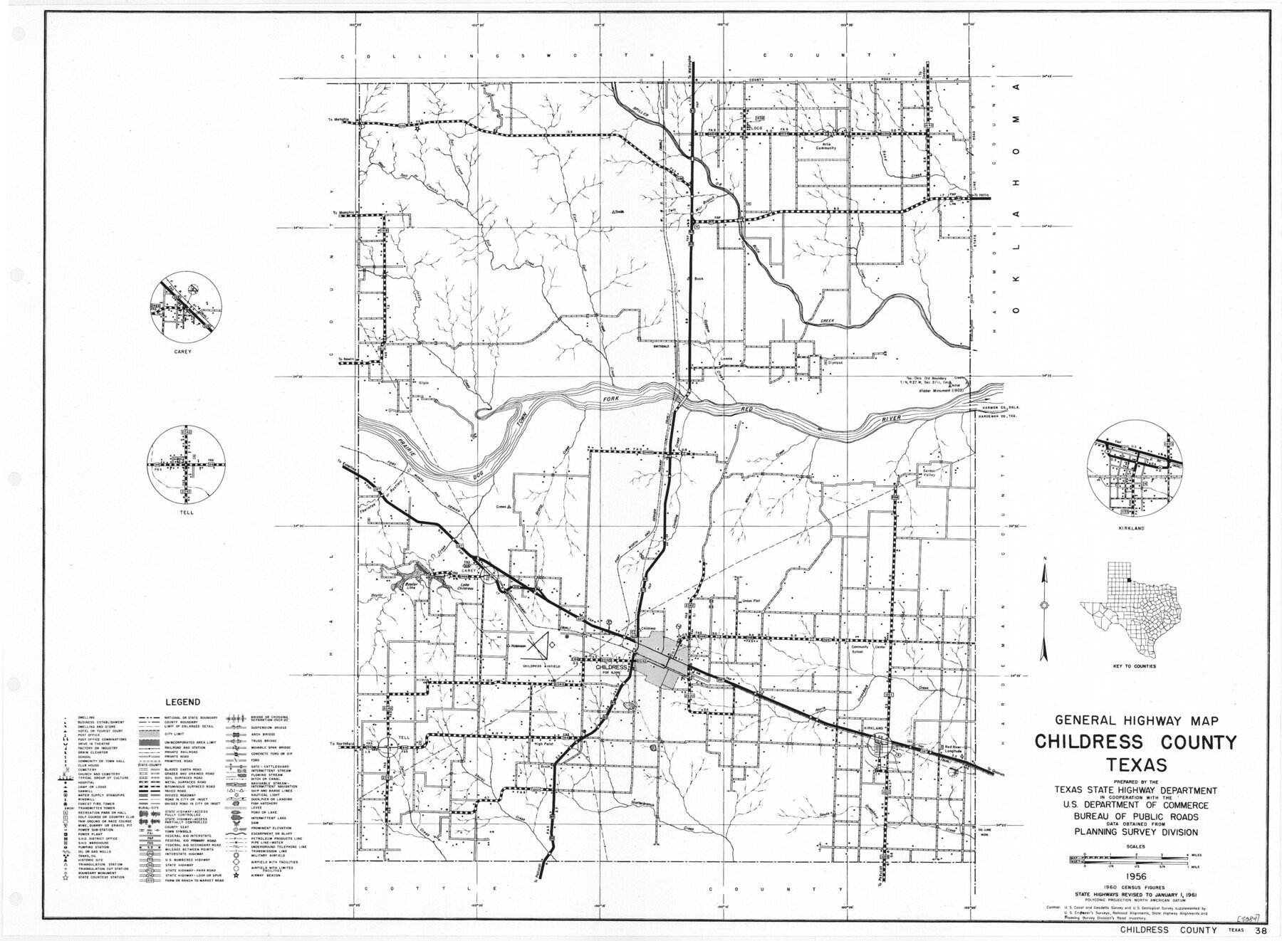
General Highway Map, Childress County, Texas
-
Map/Doc
79408
-
Collection
Texas State Library and Archives
-
Object Dates
1961 (Creation Date)
-
People and Organizations
Texas State Highway Department (Publisher)
-
Counties
Childress
-
Subjects
County
-
Height x Width
18.2 x 24.8 inches
46.2 x 63.0 cm
-
Comments
Prints available courtesy of the Texas State Library and Archives.
More info can be found here: TSLAC Map 05084
Part of: Texas State Library and Archives
General Highway Map. Detail of Cities and Towns in Bell County, Texas [Belton and Rogers and vicinity]
![79369, General Highway Map. Detail of Cities and Towns in Bell County, Texas [Belton and Rogers and vicinity], Texas State Library and Archives](https://historictexasmaps.com/wmedia_w700/maps/79369.tif.jpg)
Print $20.00
General Highway Map. Detail of Cities and Towns in Bell County, Texas [Belton and Rogers and vicinity]
1961
Size 25.0 x 18.3 inches
Map/Doc 79369
General Highway Map, Newton County, Texas

Print $20.00
General Highway Map, Newton County, Texas
1961
Size 19.3 x 25.0 inches
Map/Doc 79612
Map of Texas and the Countries Adjacent compiled in the Bureau of the Corps of Topographical Engineers from the Best Authorities

Print $20.00
Map of Texas and the Countries Adjacent compiled in the Bureau of the Corps of Topographical Engineers from the Best Authorities
1844
Size 24.5 x 35.8 inches
Map/Doc 76197
Pressler's Map of the State of Texas

Print $40.00
Pressler's Map of the State of Texas
1858
Size 48.0 x 52.5 inches
Map/Doc 76232
General Highway Map, Brazoria County, Texas

Print $20.00
General Highway Map, Brazoria County, Texas
1961
Size 24.9 x 18.1 inches
Map/Doc 79383
General Highway Map, La Salle County, Texas

Print $20.00
General Highway Map, La Salle County, Texas
1961
Size 18.2 x 24.8 inches
Map/Doc 79565
General Highway Map, Upshur County, Gregg County, Texas

Print $20.00
General Highway Map, Upshur County, Gregg County, Texas
1939
Size 24.9 x 18.6 inches
Map/Doc 79105
General Highway Map, Winkler County, Texas

Print $20.00
General Highway Map, Winkler County, Texas
1961
Size 18.2 x 24.8 inches
Map/Doc 79716

General Highway Map, Van Zandt County, Texas

Print $20.00
General Highway Map, Van Zandt County, Texas
1961
Size 18.2 x 24.8 inches
Map/Doc 79696
Description of Best Route from Austin to San Antonio, Texas

Print $20.00
Description of Best Route from Austin to San Antonio, Texas
1865
Size 12.9 x 13.1 inches
Map/Doc 79296
General Highway Map, Victoria County, Texas

Print $20.00
General Highway Map, Victoria County, Texas
1961
Size 25.0 x 18.3 inches
Map/Doc 79697
You may also like
Haskell County Sketch File 8

Print $20.00
- Digital $50.00
Haskell County Sketch File 8
Size 28.3 x 24.7 inches
Map/Doc 11740
Texas City Channel, Texas, Channel and Turning Basin Dredging - Sheet 5

Print $20.00
- Digital $50.00
Texas City Channel, Texas, Channel and Turning Basin Dredging - Sheet 5
1958
Size 28.2 x 40.9 inches
Map/Doc 61835
Pecos County Rolled Sketch DK3

Print $20.00
- Digital $50.00
Pecos County Rolled Sketch DK3
1938
Size 35.3 x 42.3 inches
Map/Doc 9715
Gaines County Rolled Sketch 7

Print $40.00
- Digital $50.00
Gaines County Rolled Sketch 7
1915
Size 35.7 x 54.0 inches
Map/Doc 9014
Newton County Rolled Sketch 15

Print $20.00
- Digital $50.00
Newton County Rolled Sketch 15
1953
Size 26.0 x 43.7 inches
Map/Doc 6845
Potter County Sketch File 5

Print $20.00
- Digital $50.00
Potter County Sketch File 5
1890
Size 14.1 x 8.8 inches
Map/Doc 34387
Wise County Sketch File 40

Print $4.00
- Digital $50.00
Wise County Sketch File 40
1875
Size 8.0 x 10.6 inches
Map/Doc 40597
Young County Working Sketch 7

Print $20.00
- Digital $50.00
Young County Working Sketch 7
1919
Size 24.3 x 19.8 inches
Map/Doc 62030
Nueces County Rolled Sketch 27A

Print $40.00
- Digital $50.00
Nueces County Rolled Sketch 27A
1946
Size 11.6 x 52.4 inches
Map/Doc 76042
Brazos Santiago, Texas

Print $20.00
- Digital $50.00
Brazos Santiago, Texas
1900
Size 18.3 x 26.8 inches
Map/Doc 73033
Menard County Sketch File 21

Print $40.00
- Digital $50.00
Menard County Sketch File 21
1913
Size 14.1 x 14.8 inches
Map/Doc 31551
Williamson County State Real Property Sketch 1

Print $20.00
- Digital $50.00
Williamson County State Real Property Sketch 1
1985
Size 46.1 x 36.2 inches
Map/Doc 61692