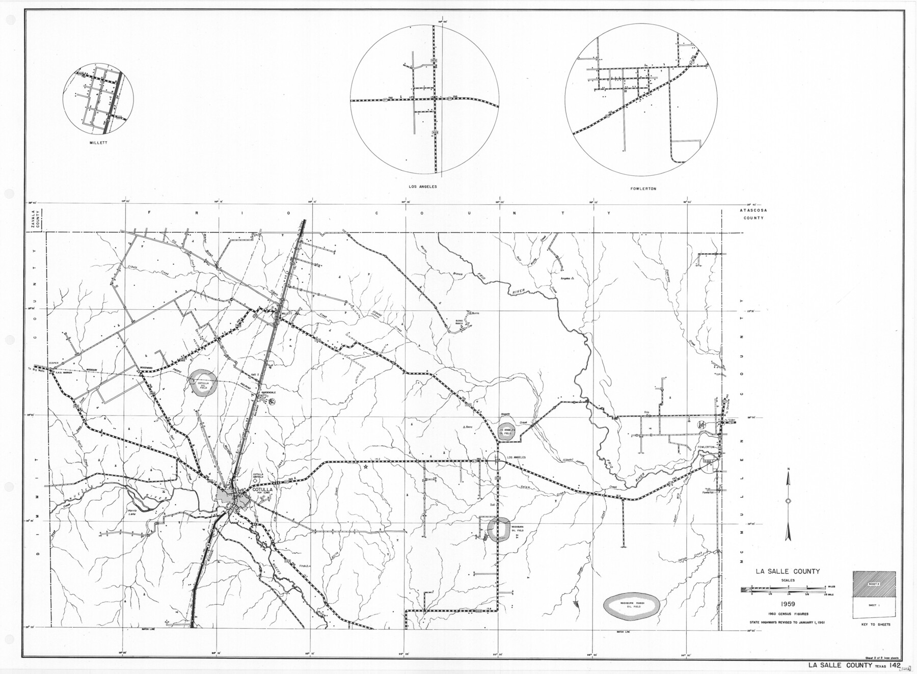
General Highway Map, La Salle County, Texas
-
Map/Doc
79565
-
Collection
Texas State Library and Archives
-
Object Dates
1961 (Creation Date)
-
People and Organizations
Texas State Highway Department (Publisher)
-
Counties
La Salle
-
Subjects
County
-
Height x Width
18.2 x 24.8 inches
46.2 x 63.0 cm
-
Comments
Prints available courtesy of the Texas State Library and Archives.
More info can be found here: TSLAC Map 05212
Part of: Texas State Library and Archives
Military Map of Southwestern Texas

Print $20.00
Military Map of Southwestern Texas
1881
Size 24.3 x 38.4 inches
Map/Doc 76316
General Highway Map, Kerr County, Texas

Print $20.00
General Highway Map, Kerr County, Texas
1961
Size 24.6 x 18.2 inches
Map/Doc 79552
General Highway Map. Detail of Cities and Towns in Harris County, Texas. City Map [of] Houston, Pasadena, West University Place, Bellaire, Galena Park, Jacinto City, South Houston, South Side Place, Deer Park, and vicinity, Harris County, Texas
![79505, General Highway Map. Detail of Cities and Towns in Harris County, Texas. City Map [of] Houston, Pasadena, West University Place, Bellaire, Galena Park, Jacinto City, South Houston, South Side Place, Deer Park, and vicinity, Harris County, Texas, Texas State Library and Archives](https://historictexasmaps.com/wmedia_w700/maps/79505.tif.jpg)
Print $20.00
General Highway Map. Detail of Cities and Towns in Harris County, Texas. City Map [of] Houston, Pasadena, West University Place, Bellaire, Galena Park, Jacinto City, South Houston, South Side Place, Deer Park, and vicinity, Harris County, Texas
1961
Size 18.0 x 25.0 inches
Map/Doc 79505
General Highway Map, Llano County, Texas

Print $20.00
General Highway Map, Llano County, Texas
1961
Size 18.2 x 24.6 inches
Map/Doc 79576
General Highway Map, Zapata County, Texas

Print $20.00
General Highway Map, Zapata County, Texas
1940
Size 18.4 x 24.8 inches
Map/Doc 79287
General Highway Map, Hartley County, Texas

Print $20.00
General Highway Map, Hartley County, Texas
1961
Size 24.8 x 18.2 inches
Map/Doc 79510
Stremme General Land Office Drawings, front view

Print $20.00
Stremme General Land Office Drawings, front view
Size 14.0 x 20.8 inches
Map/Doc 79738
General Highway Map, Kerr County, Texas

Print $20.00
General Highway Map, Kerr County, Texas
1940
Size 24.8 x 18.2 inches
Map/Doc 79157
General Highway Map, Harris County, Texas

Print $20.00
General Highway Map, Harris County, Texas
1939
Size 24.7 x 18.4 inches
Map/Doc 79115
General Highway Map, Oldham County, Deaf Smith County, Texas

Print $20.00
General Highway Map, Oldham County, Deaf Smith County, Texas
1940
Size 18.3 x 25.2 inches
Map/Doc 79072
General Highway Map, Dawson County, Texas

Print $20.00
General Highway Map, Dawson County, Texas
1961
Size 18.0 x 24.5 inches
Map/Doc 79436
General Highway Map, Frio County, Texas

Print $20.00
General Highway Map, Frio County, Texas
1961
Size 18.2 x 24.5 inches
Map/Doc 79473
You may also like
Kendall County Working Sketch 8

Print $20.00
- Digital $50.00
Kendall County Working Sketch 8
1951
Size 24.5 x 25.0 inches
Map/Doc 66680
Flight Mission No. CRC-4R, Frame 162, Chambers County

Print $20.00
- Digital $50.00
Flight Mission No. CRC-4R, Frame 162, Chambers County
1956
Size 18.6 x 22.4 inches
Map/Doc 84921
Flight Mission No. BRE-1P, Frame 118, Nueces County

Print $20.00
- Digital $50.00
Flight Mission No. BRE-1P, Frame 118, Nueces County
1956
Size 17.8 x 21.2 inches
Map/Doc 86684
Starr County Working Sketch 27

Print $20.00
- Digital $50.00
Starr County Working Sketch 27
1994
Size 29.6 x 30.3 inches
Map/Doc 63943
Eastland County Working Sketch 61

Print $20.00
- Digital $50.00
Eastland County Working Sketch 61
1989
Size 35.4 x 41.0 inches
Map/Doc 68842
[Maps of surveys in Reeves & Culberson Cos]
![61146, [Maps of surveys in Reeves & Culberson Cos], General Map Collection](https://historictexasmaps.com/wmedia_w700/maps/61146.tif.jpg)
Print $20.00
- Digital $50.00
[Maps of surveys in Reeves & Culberson Cos]
1937
Size 30.8 x 24.9 inches
Map/Doc 61146
Current Miscellaneous File 68

Print $22.00
- Digital $50.00
Current Miscellaneous File 68
Size 11.2 x 8.8 inches
Map/Doc 74134
Lampasas County Sketch File 5

Print $8.00
- Digital $50.00
Lampasas County Sketch File 5
1869
Size 12.8 x 7.9 inches
Map/Doc 29396
Hardin County Rolled Sketch MH

Print $21.00
- Digital $50.00
Hardin County Rolled Sketch MH
1936
Size 10.1 x 15.2 inches
Map/Doc 45760
Matagorda County Sketch File 39

Print $20.00
- Digital $50.00
Matagorda County Sketch File 39
Size 31.1 x 24.3 inches
Map/Doc 12047
Presidio County Working Sketch 69

Print $20.00
- Digital $50.00
Presidio County Working Sketch 69
1960
Size 33.3 x 41.3 inches
Map/Doc 71746
Montgomery County Sketch File 23

Print $6.00
- Digital $50.00
Montgomery County Sketch File 23
1841
Size 10.2 x 10.8 inches
Map/Doc 31865