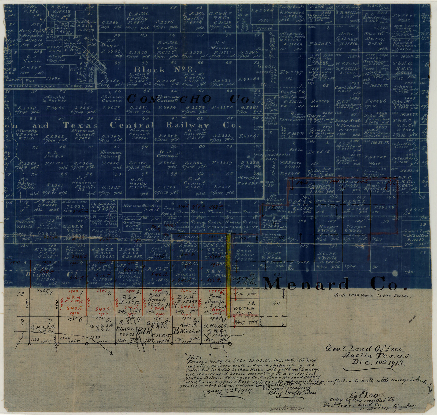
Menard County Sketch File 21
[Office sketch on line of Menard and Concho Counties]
-
Map/Doc
31551
-
Collection
General Map Collection
-
Object Dates
12/10/1913 (Creation Date)
-
People and Organizations
E. von Rosenberg (Draftsman)
-
Counties
Menard Concho
-
Subjects
Surveying Sketch File
-
Height x Width
14.1 x 14.8 inches
35.8 x 37.6 cm
-
Medium
blueprint/diazo
-
Scale
1:2000
-
Features
Clauss Creek
Part of: General Map Collection
San Patricio County Working Sketch 15

Print $20.00
- Digital $50.00
San Patricio County Working Sketch 15
1951
Size 20.9 x 25.6 inches
Map/Doc 63777
[Bastrop District]
![83517, [Bastrop District], General Map Collection](https://historictexasmaps.com/wmedia_w700/maps/83517-1.tif.jpg)
Print $20.00
- Digital $50.00
[Bastrop District]
1838
Size 25.1 x 46.1 inches
Map/Doc 83517
Sketch exhibiting the San Antonio River from the source to the fork of Goliad

Print $20.00
- Digital $50.00
Sketch exhibiting the San Antonio River from the source to the fork of Goliad
Size 27.5 x 16.6 inches
Map/Doc 73009
Ector County Sketch File 3

Print $20.00
- Digital $50.00
Ector County Sketch File 3
1889
Size 16.2 x 35.5 inches
Map/Doc 11417
Flight Mission No. DCL-7C, Frame 22, Kenedy County

Print $20.00
- Digital $50.00
Flight Mission No. DCL-7C, Frame 22, Kenedy County
1943
Size 15.4 x 15.2 inches
Map/Doc 86014
Navasota River, Springfield Sheet

Print $20.00
- Digital $50.00
Navasota River, Springfield Sheet
1934
Size 41.5 x 37.8 inches
Map/Doc 65074
Texas Panhandle East Boundary Line

Print $20.00
- Digital $50.00
Texas Panhandle East Boundary Line
Size 37.5 x 8.7 inches
Map/Doc 65381
Flight Mission No. DAG-26K, Frame 82, Matagorda County

Print $20.00
- Digital $50.00
Flight Mission No. DAG-26K, Frame 82, Matagorda County
1953
Size 18.4 x 19.1 inches
Map/Doc 86587
Erath County Sketch File 2

Print $20.00
- Digital $50.00
Erath County Sketch File 2
Size 13.2 x 15.5 inches
Map/Doc 11463
Polk County Sketch File 11

Print $4.00
- Digital $50.00
Polk County Sketch File 11
Size 9.2 x 8.1 inches
Map/Doc 34142
Flight Mission No. CGI-4N, Frame 22, Cameron County

Print $20.00
- Digital $50.00
Flight Mission No. CGI-4N, Frame 22, Cameron County
1954
Size 18.5 x 22.3 inches
Map/Doc 84655
San Patricio County Sketch File 11

Print $6.00
San Patricio County Sketch File 11
1846
Size 13.3 x 8.3 inches
Map/Doc 36044
You may also like
Kinney County Working Sketch 51

Print $20.00
- Digital $50.00
Kinney County Working Sketch 51
1980
Size 34.6 x 47.2 inches
Map/Doc 70233
Bandera County Sketch File 2

Print $4.00
- Digital $50.00
Bandera County Sketch File 2
1855
Size 7.1 x 7.9 inches
Map/Doc 13997
Flight Mission No. BQR-4K, Frame 67, Brazoria County

Print $20.00
- Digital $50.00
Flight Mission No. BQR-4K, Frame 67, Brazoria County
1952
Size 18.7 x 22.5 inches
Map/Doc 84000
Pecos County Rolled Sketch 79

Print $20.00
- Digital $50.00
Pecos County Rolled Sketch 79
1930
Size 28.5 x 32.6 inches
Map/Doc 7239
Pecos County Rolled Sketch 124

Print $20.00
- Digital $50.00
Pecos County Rolled Sketch 124
Size 22.8 x 18.8 inches
Map/Doc 7265
[Beaumont, Sour Lake and Western Ry. Right of Way and Alignment - Frisco]
![64128, [Beaumont, Sour Lake and Western Ry. Right of Way and Alignment - Frisco], General Map Collection](https://historictexasmaps.com/wmedia_w700/maps/64128.tif.jpg)
Print $20.00
- Digital $50.00
[Beaumont, Sour Lake and Western Ry. Right of Way and Alignment - Frisco]
1910
Size 20.1 x 45.9 inches
Map/Doc 64128
Bexar County Sketch File 27

Print $4.00
- Digital $50.00
Bexar County Sketch File 27
1860
Size 8.6 x 6.5 inches
Map/Doc 14490
Orange County NRC Article 33.136 Sketch 6

Print $42.00
Orange County NRC Article 33.136 Sketch 6
2025
Map/Doc 97430
General Highway Map, Harrison County, Texas

Print $20.00
General Highway Map, Harrison County, Texas
1940
Size 18.2 x 24.8 inches
Map/Doc 79121
San Patricio County Sketch File 20

Print $14.00
San Patricio County Sketch File 20
1868
Size 9.2 x 8.5 inches
Map/Doc 36069
Hamilton County Working Sketch 34

Print $20.00
- Digital $50.00
Hamilton County Working Sketch 34
1995
Size 37.7 x 39.8 inches
Map/Doc 63372
[Surveys in the Bexar District along the Medina River]
![130, [Surveys in the Bexar District along the Medina River], General Map Collection](https://historictexasmaps.com/wmedia_w700/maps/130.tif.jpg)
Print $20.00
- Digital $50.00
[Surveys in the Bexar District along the Medina River]
1841
Size 20.7 x 12.8 inches
Map/Doc 130