Williamson County State Real Property Sketch 1
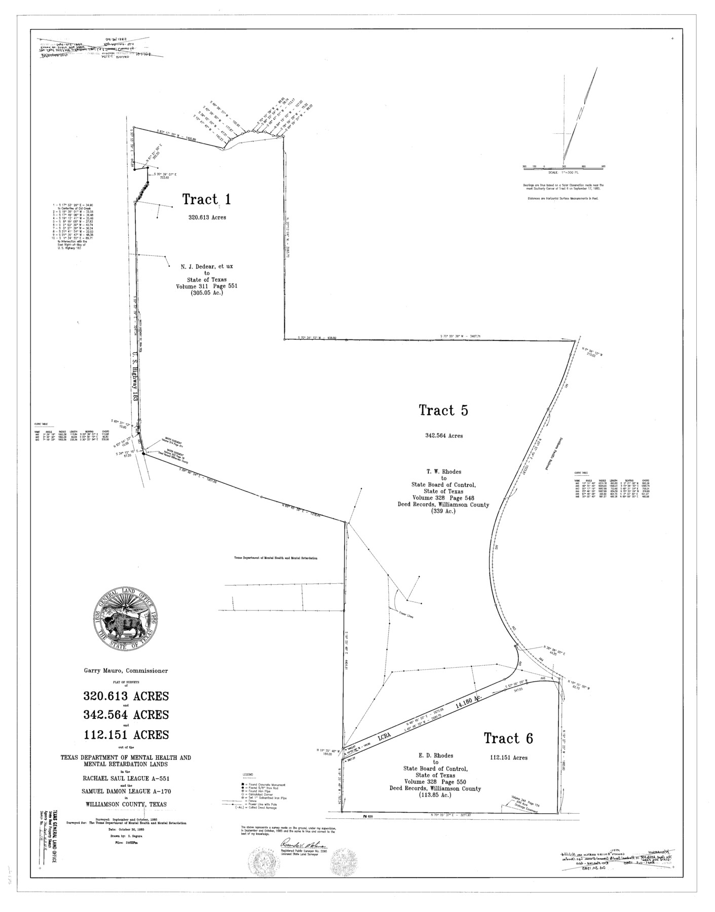
A Plat of Surveys of 320.613 Acres, 342.564 Acres, and 112.151 Acres Out of the Texas Department of Mental Health and Mental Retardation Lands in the Rachael Saul League, A - 551 and the Samuel Damon League, A - 170, State Hog Farm
State Real Property Sketch L - 18; N-1-104
-
Map/Doc
61692
-
Collection
General Map Collection
-
Object Dates
1985/10/30 (Creation Date)
-
People and Organizations
Texas General Land Office (Publisher)
Texas General Land Office (Printer)
S. Segura (Draftsman)
S. Segura (Compiler)
Garry Mauro (GLO Commissioner)
Rosendo V. Molina (Surveyor/Engineer)
-
Counties
Williamson
-
Subjects
State Real Property
-
Height x Width
46.1 x 36.2 inches
117.1 x 91.9 cm
-
Comments
Surveyed September and October 1985.
Surveys located about 14 miles South 35 degrees West of Georgetown, Texas.
One or more items in this file were formerly filed in another file. They have been reunited in this file with their original grouping.
Part of: General Map Collection
Flight Mission No. CGI-3N, Frame 48, Cameron County

Print $20.00
- Digital $50.00
Flight Mission No. CGI-3N, Frame 48, Cameron County
1954
Size 18.7 x 22.2 inches
Map/Doc 84554
Johnson County Sketch File 1

Print $48.00
- Digital $50.00
Johnson County Sketch File 1
Size 8.0 x 6.9 inches
Map/Doc 28427
Hale County Boundary File 4

Print $40.00
- Digital $50.00
Hale County Boundary File 4
Size 8.8 x 4.2 inches
Map/Doc 54048
Upton County Working Sketch 22

Print $40.00
- Digital $50.00
Upton County Working Sketch 22
1951
Size 37.5 x 48.7 inches
Map/Doc 69518
Flight Mission No. DQO-8K, Frame 18, Galveston County

Print $20.00
- Digital $50.00
Flight Mission No. DQO-8K, Frame 18, Galveston County
1952
Size 18.6 x 22.4 inches
Map/Doc 85141
Orange County Working Sketch 22

Print $20.00
- Digital $50.00
Orange County Working Sketch 22
1939
Size 35.8 x 35.5 inches
Map/Doc 71354
Val Verde County Sketch File 37

Print $24.00
- Digital $50.00
Val Verde County Sketch File 37
1938
Size 15.5 x 22.3 inches
Map/Doc 12578
Hood County Rolled Sketch 3

Print $20.00
- Digital $50.00
Hood County Rolled Sketch 3
1967
Size 33.2 x 36.2 inches
Map/Doc 9179
Smith Co. showing location of Texas and Pacific Railway

Print $20.00
- Digital $50.00
Smith Co. showing location of Texas and Pacific Railway
1872
Size 19.5 x 21.6 inches
Map/Doc 64139
Jefferson County Working Sketch 14

Print $20.00
- Digital $50.00
Jefferson County Working Sketch 14
1948
Size 30.3 x 25.8 inches
Map/Doc 66557
Flight Mission No. DQO-2K, Frame 151, Galveston County

Print $20.00
- Digital $50.00
Flight Mission No. DQO-2K, Frame 151, Galveston County
1952
Size 18.9 x 22.6 inches
Map/Doc 85048
Pecos County Working Sketch 78

Print $20.00
- Digital $50.00
Pecos County Working Sketch 78
1960
Size 29.4 x 34.4 inches
Map/Doc 71550
You may also like
San Saba County

Print $20.00
- Digital $50.00
San Saba County
1987
Size 46.3 x 42.5 inches
Map/Doc 73284
McLennan County Sketch File 4a

Print $6.00
- Digital $50.00
McLennan County Sketch File 4a
Size 9.2 x 7.9 inches
Map/Doc 31237

Houston County Sketch File 9

Print $4.00
- Digital $50.00
Houston County Sketch File 9
1857
Size 12.7 x 8.1 inches
Map/Doc 26771
Flight Mission No. DQN-5K, Frame 39, Calhoun County

Print $20.00
- Digital $50.00
Flight Mission No. DQN-5K, Frame 39, Calhoun County
1953
Size 18.5 x 22.1 inches
Map/Doc 84387
Kinney County Sketch File 27

Print $42.00
- Digital $50.00
Kinney County Sketch File 27
1929
Size 32.4 x 13.2 inches
Map/Doc 11946
Jasper County Sketch File 11

Print $5.00
- Digital $50.00
Jasper County Sketch File 11
Size 11.1 x 9.6 inches
Map/Doc 27790
Terrell County Sketch File 37

Print $4.00
- Digital $50.00
Terrell County Sketch File 37
Size 14.5 x 9.1 inches
Map/Doc 37999
Shelby County Rolled Sketch 13

Print $20.00
- Digital $50.00
Shelby County Rolled Sketch 13
1945
Size 24.5 x 27.8 inches
Map/Doc 7781
Jasper County Working Sketch 14

Print $40.00
- Digital $50.00
Jasper County Working Sketch 14
1920
Size 37.9 x 55.1 inches
Map/Doc 66476
Montgomery County Rolled Sketch 16

Print $20.00
- Digital $50.00
Montgomery County Rolled Sketch 16
Size 28.5 x 26.6 inches
Map/Doc 6804
Cherokee County Working Sketch 23
Print $20.00
- Digital $50.00
Cherokee County Working Sketch 23
1972
Size 44.4 x 46.9 inches
Map/Doc 67978