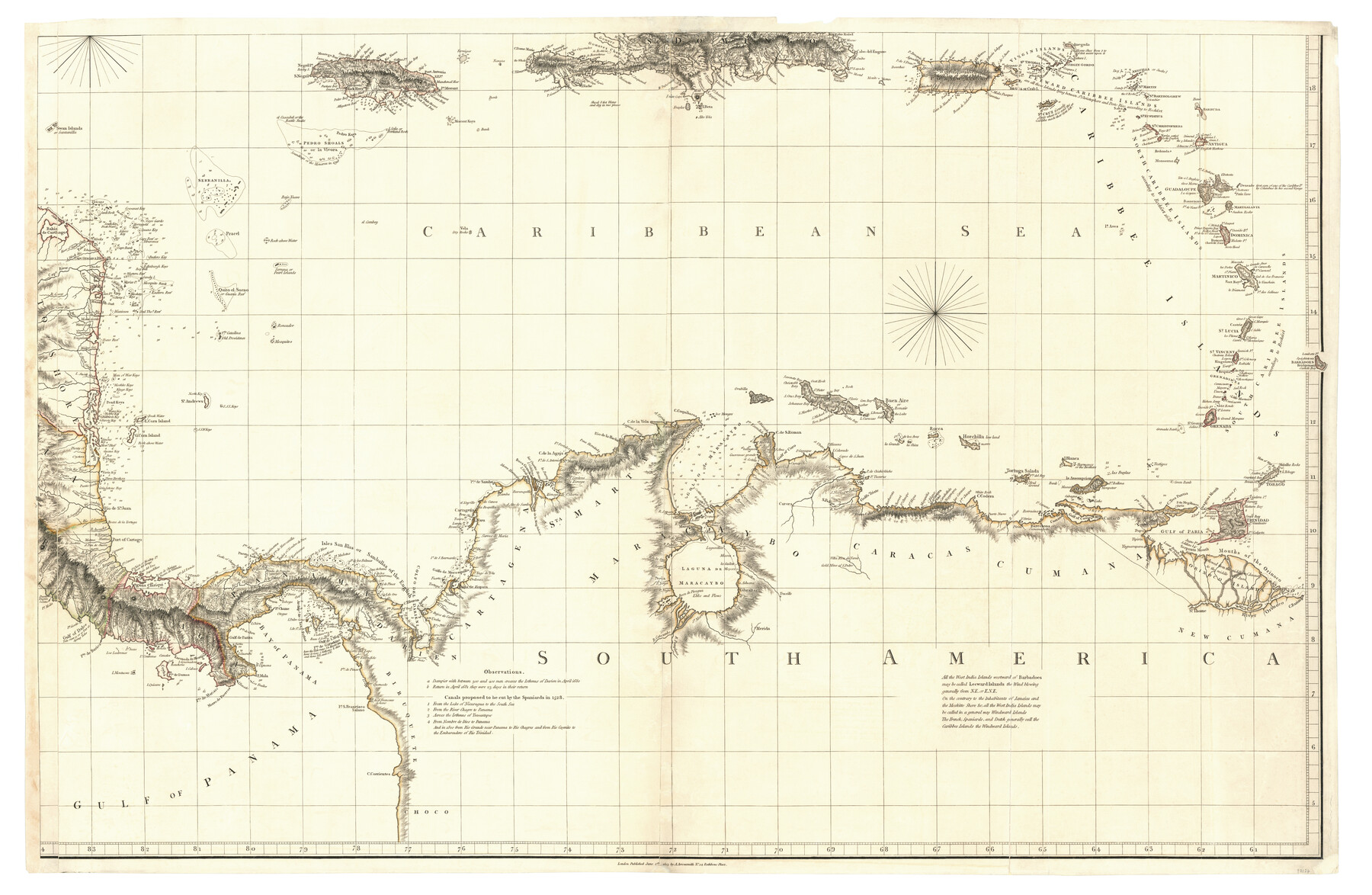
Chart of the West Indies and Spanish Dominions in North America
-
Map/Doc
97137
-
Collection
General Map Collection
-
Object Dates
6/1/1803 (Creation Date)
-
People and Organizations
A. Arrowsmith (Publisher)
-
Height x Width
25.7 x 39.4 inches
65.3 x 100.1 cm
-
Comments
SE quadrant of a map in four pieces. See 97136, 97138, and 97139 for other pieces. See 97153 for digital composite of all four pieces.
Related maps
Chart of the West Indies and Spanish Dominions in North America

Print $20.00
- Digital $50.00
Chart of the West Indies and Spanish Dominions in North America
1803
Size 25.3 x 38.4 inches
Map/Doc 97136
Chart of the West Indies and Spanish Dominions in North America

Print $20.00
- Digital $50.00
Chart of the West Indies and Spanish Dominions in North America
1803
Size 25.6 x 39.2 inches
Map/Doc 97138
Chart of the West Indies and Spanish Dominions in North America

Print $20.00
- Digital $50.00
Chart of the West Indies and Spanish Dominions in North America
1803
Size 25.5 x 38.9 inches
Map/Doc 97139
Chart of the West Indies and Spanish Dominions in North America

Print $40.00
- Digital $50.00
Chart of the West Indies and Spanish Dominions in North America
Size 49.1 x 75.6 inches
Map/Doc 97153
Part of: General Map Collection
Cooke County Working Sketch Graphic Index

Print $20.00
- Digital $50.00
Cooke County Working Sketch Graphic Index
1935
Size 44.7 x 38.2 inches
Map/Doc 76504
Caldwell County Sketch File 3

Print $4.00
- Digital $50.00
Caldwell County Sketch File 3
1872
Size 12.7 x 8.1 inches
Map/Doc 35827
Denton County Sketch File 23

Print $5.00
- Digital $50.00
Denton County Sketch File 23
1862
Size 9.3 x 11.4 inches
Map/Doc 20748
Lynn County Boundary File 13

Print $40.00
- Digital $50.00
Lynn County Boundary File 13
Size 36.1 x 8.2 inches
Map/Doc 56752
Val Verde County Sketch File Z5

Print $20.00
- Digital $50.00
Val Verde County Sketch File Z5
Size 32.3 x 26.1 inches
Map/Doc 12551
Presidio County Sketch File 59

Print $12.00
- Digital $50.00
Presidio County Sketch File 59
1935
Size 8.7 x 7.5 inches
Map/Doc 34637
Hudspeth County Working Sketch 47

Print $20.00
- Digital $50.00
Hudspeth County Working Sketch 47
1984
Size 27.3 x 38.6 inches
Map/Doc 78211
McLennan County Sketch File 21

Print $4.00
- Digital $50.00
McLennan County Sketch File 21
Size 9.0 x 8.2 inches
Map/Doc 31294
San Patricio County NRC Article 33.136 Sketch 8

Print $26.00
- Digital $50.00
San Patricio County NRC Article 33.136 Sketch 8
2018
Size 11.0 x 17.0 inches
Map/Doc 95341
Brewster County Rolled Sketch 80

Print $40.00
- Digital $50.00
Brewster County Rolled Sketch 80
1943
Size 51.6 x 42.7 inches
Map/Doc 8493
La Salle County Sketch File 21

Print $6.00
- Digital $50.00
La Salle County Sketch File 21
1883
Size 11.0 x 10.5 inches
Map/Doc 29526
Val Verde County Sketch File 49

Print $20.00
- Digital $50.00
Val Verde County Sketch File 49
1953
Size 27.1 x 20.2 inches
Map/Doc 12590
You may also like
Montgomery County Texas Historical Map

Montgomery County Texas Historical Map
Size 23.2 x 35.5 inches
Map/Doc 94403
[Block E, and Portions of Blocks 20 and S]
![91327, [Block E, and Portions of Blocks 20 and S], Twichell Survey Records](https://historictexasmaps.com/wmedia_w700/maps/91327-1.tif.jpg)
Print $20.00
- Digital $50.00
[Block E, and Portions of Blocks 20 and S]
Size 14.9 x 30.2 inches
Map/Doc 91327
Pecos County Rolled Sketch 134

Print $20.00
- Digital $50.00
Pecos County Rolled Sketch 134
1952
Size 35.9 x 27.0 inches
Map/Doc 7270
[Worksheets related to the Wilson Strickland survey and vicinity]
![91266, [Vicinity and related to the Wilson Strickland Survey], Twichell Survey Records](https://historictexasmaps.com/wmedia_w700/maps/91266-1.tif.jpg)
Print $20.00
- Digital $50.00
[Worksheets related to the Wilson Strickland survey and vicinity]
Size 35.8 x 17.5 inches
Map/Doc 91266
Flight Mission No. CLL-1N, Frame 105, Willacy County

Print $20.00
- Digital $50.00
Flight Mission No. CLL-1N, Frame 105, Willacy County
1954
Size 18.4 x 22.1 inches
Map/Doc 87039
Tarrant County Working Sketch 8

Print $20.00
- Digital $50.00
Tarrant County Working Sketch 8
1982
Size 33.2 x 19.7 inches
Map/Doc 62425

[Sketch showing Blocks B5, B6 and G.&M. Block 5 north of Capitol Land]
![92989, [Sketch showing Blocks B5, B6 and G.&M. Block 5 north of Capitol Land], Twichell Survey Records](https://historictexasmaps.com/wmedia_w700/maps/92989-1.tif.jpg)
Print $20.00
- Digital $50.00
[Sketch showing Blocks B5, B6 and G.&M. Block 5 north of Capitol Land]
Size 38.4 x 20.9 inches
Map/Doc 92989
Shelby County Sketch File 15

Print $6.00
- Digital $50.00
Shelby County Sketch File 15
1872
Size 10.2 x 15.5 inches
Map/Doc 36624
Coke County Rolled Sketch 4

Print $20.00
- Digital $50.00
Coke County Rolled Sketch 4
Size 44.6 x 37.0 inches
Map/Doc 8624
Marion County Sketch File 15

Print $10.00
- Digital $50.00
Marion County Sketch File 15
1958
Size 14.3 x 8.8 inches
Map/Doc 30585
Culberson County Working Sketch 71

Print $40.00
- Digital $50.00
Culberson County Working Sketch 71
1975
Size 48.4 x 32.9 inches
Map/Doc 68525