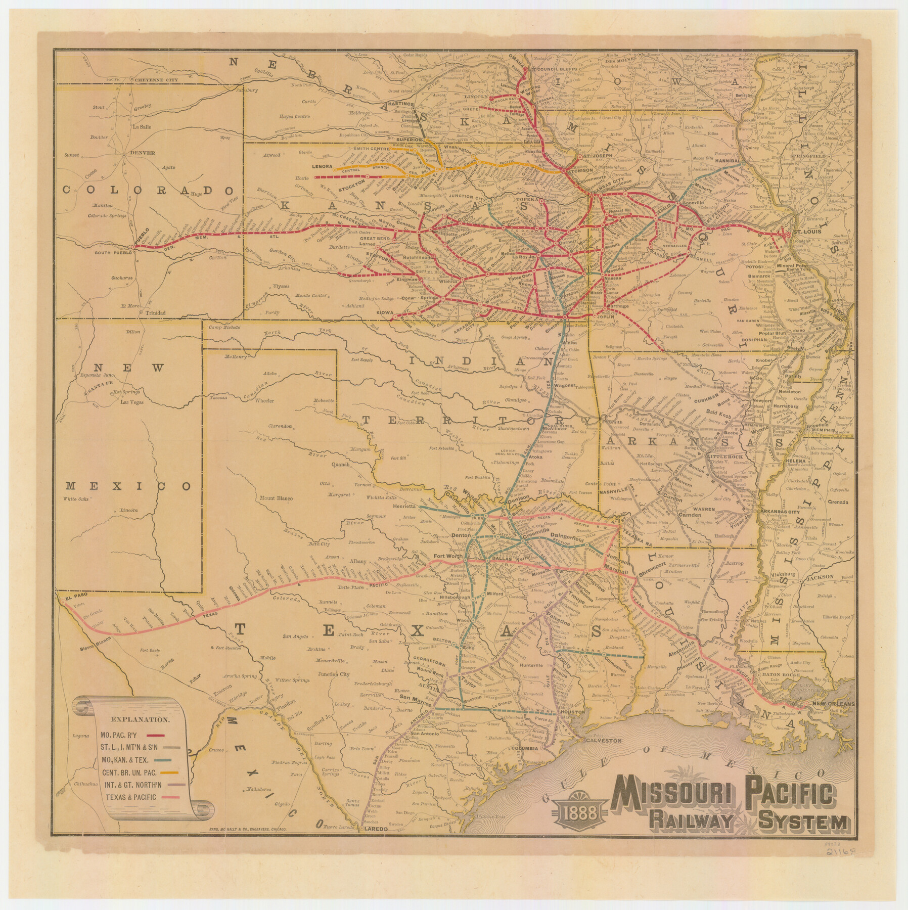
Missouri Pacific Railway System
-
Map/Doc
89223
-
Collection
General Map Collection
-
Object Dates
1888 (Creation Date)
2009/10/23 (File Date)
-
People and Organizations
Rand, McNally and Co. (Publisher)
Rand, McNally and Co. (Printer)
-
Subjects
Old Southwest Railroads State of Texas
-
Height x Width
20.0 x 20.0 inches
50.8 x 50.8 cm
-
Comments
Shows routes of six different railway lines through Texas, Colorado, Kansas, Nebraska, Missouri. Arkansas, and Indian Territory (Oklahoma).
Part of: General Map Collection
Laguna Madre, Texas from Triangulation Station Singer to Latitude 26° 20'

Print $40.00
- Digital $50.00
Laguna Madre, Texas from Triangulation Station Singer to Latitude 26° 20'
1880
Size 31.9 x 53.4 inches
Map/Doc 73493
Flight Mission No. BRA-7M, Frame 4, Jefferson County

Print $20.00
- Digital $50.00
Flight Mission No. BRA-7M, Frame 4, Jefferson County
1953
Size 18.7 x 22.2 inches
Map/Doc 85455
Briscoe County Sketch File B

Print $40.00
- Digital $50.00
Briscoe County Sketch File B
1900
Size 23.6 x 37.0 inches
Map/Doc 10998
Fannin County Boundary File 7

Print $42.00
- Digital $50.00
Fannin County Boundary File 7
Size 5.3 x 31.1 inches
Map/Doc 53313
Calhoun County Rolled Sketch 30

Print $20.00
- Digital $50.00
Calhoun County Rolled Sketch 30
1974
Size 18.5 x 27.5 inches
Map/Doc 5496
Gulf Coast of the United States, Key West to Rio Grande

Print $20.00
- Digital $50.00
Gulf Coast of the United States, Key West to Rio Grande
1863
Size 27.4 x 18.3 inches
Map/Doc 72666
Flight Mission No. CGI-4N, Frame 193, Cameron County

Print $20.00
- Digital $50.00
Flight Mission No. CGI-4N, Frame 193, Cameron County
1955
Size 18.6 x 22.3 inches
Map/Doc 84696
Hardeman County Rolled Sketch 20

Print $40.00
- Digital $50.00
Hardeman County Rolled Sketch 20
Size 32.3 x 60.8 inches
Map/Doc 9102
Webb County Working Sketch 84

Print $20.00
- Digital $50.00
Webb County Working Sketch 84
1979
Size 27.0 x 24.3 inches
Map/Doc 72451
Polk County Working Sketch 38

Print $20.00
- Digital $50.00
Polk County Working Sketch 38
1975
Size 25.4 x 23.5 inches
Map/Doc 71655
Map of a part of Laguna Madre showing subdivision for mineral development

Print $20.00
- Digital $50.00
Map of a part of Laguna Madre showing subdivision for mineral development
1950
Size 40.7 x 26.9 inches
Map/Doc 2917
McMullen County Working Sketch 42

Print $20.00
- Digital $50.00
McMullen County Working Sketch 42
1980
Size 35.6 x 32.6 inches
Map/Doc 70743
You may also like
Flight Mission No. BQR-5K, Frame 75, Brazoria County

Print $20.00
- Digital $50.00
Flight Mission No. BQR-5K, Frame 75, Brazoria County
1952
Size 18.8 x 22.4 inches
Map/Doc 84020
Knox County Sketch File 29

Print $20.00
- Digital $50.00
Knox County Sketch File 29
Size 18.6 x 36.1 inches
Map/Doc 11965
Jefferson County Rolled Sketch 25

Print $20.00
- Digital $50.00
Jefferson County Rolled Sketch 25
1939
Size 43.4 x 36.0 inches
Map/Doc 9290
[Geological Map of Texas]
![62962, [Geological Map of Texas], General Map Collection](https://historictexasmaps.com/wmedia_w700/maps/62962.tif.jpg)
Print $20.00
- Digital $50.00
[Geological Map of Texas]
Size 17.6 x 18.1 inches
Map/Doc 62962
Resurvey of H.L. Upshur's April 23, 1853 meanders of the Colorado River from the NE corner of Isaac Decker league to the Congress Avenue Bridge

Print $20.00
- Digital $50.00
Resurvey of H.L. Upshur's April 23, 1853 meanders of the Colorado River from the NE corner of Isaac Decker league to the Congress Avenue Bridge
1915
Size 24.1 x 15.8 inches
Map/Doc 75774
El Paso County Working Sketch 50

Print $20.00
- Digital $50.00
El Paso County Working Sketch 50
1991
Size 25.9 x 27.7 inches
Map/Doc 69072
Childress County School Land Situated in Bailey and Cochran Counties

Print $20.00
- Digital $50.00
Childress County School Land Situated in Bailey and Cochran Counties
Size 21.8 x 25.4 inches
Map/Doc 92499
Wharton County Boundary File 1a

Print $12.00
- Digital $50.00
Wharton County Boundary File 1a
Size 11.7 x 9.2 inches
Map/Doc 59851

Johnson County Boundary File 2

Print $56.00
- Digital $50.00
Johnson County Boundary File 2
Size 9.5 x 34.9 inches
Map/Doc 55556
Jeff Davis County Sketch File 46

Print $8.00
- Digital $50.00
Jeff Davis County Sketch File 46
1906
Size 13.5 x 8.8 inches
Map/Doc 28080
Flight Mission No. CRC-3R, Frame 203, Chambers County

Print $20.00
- Digital $50.00
Flight Mission No. CRC-3R, Frame 203, Chambers County
1956
Size 18.6 x 22.3 inches
Map/Doc 84858