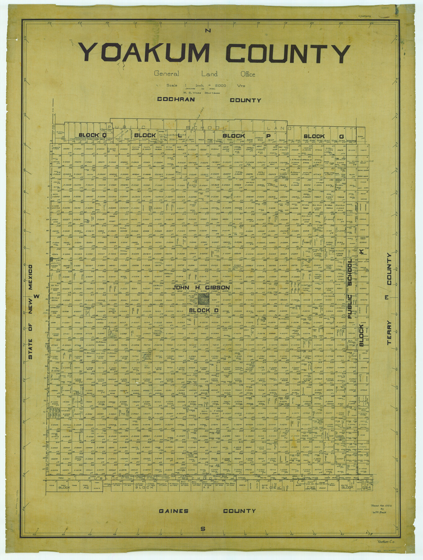
Yoakum County
-
Map/Doc
63139
-
Collection
General Map Collection
-
Object Dates
1932/1/13 (Creation Date)
-
People and Organizations
Texas General Land Office (Publisher)
W.S. Vines (Compiler)
W.S. Vines (Draftsman)
-
Counties
Yoakum
-
Subjects
County
-
Height x Width
47.1 x 35.6 inches
119.6 x 90.4 cm
-
Comments
Traced in February 1932 by W. M. Beck.
Part of: General Map Collection
Hudspeth County Working Sketch Graphic Index

Print $40.00
- Digital $50.00
Hudspeth County Working Sketch Graphic Index
1943
Size 53.7 x 39.3 inches
Map/Doc 76584
Township No. 7 South Range No. 4 West of the Indian Meridian, Chickasaw Lands

Print $4.00
- Digital $50.00
Township No. 7 South Range No. 4 West of the Indian Meridian, Chickasaw Lands
1871
Size 18.2 x 22.4 inches
Map/Doc 75146
Zapata County Sketch File 8

Print $40.00
- Digital $50.00
Zapata County Sketch File 8
1917
Size 59.5 x 26.5 inches
Map/Doc 10438
Kerr County Working Sketch 1

Print $20.00
- Digital $50.00
Kerr County Working Sketch 1
1900
Size 18.5 x 18.0 inches
Map/Doc 70032
Dimmit County Sketch File 1

Print $42.00
- Digital $50.00
Dimmit County Sketch File 1
1851
Size 8.8 x 7.5 inches
Map/Doc 21050
Henderson County Working Sketch 42

Print $20.00
- Digital $50.00
Henderson County Working Sketch 42
1990
Size 23.5 x 24.6 inches
Map/Doc 66175
Williamson County Rolled Sketch 3

Print $20.00
- Digital $50.00
Williamson County Rolled Sketch 3
1915
Size 40.1 x 30.9 inches
Map/Doc 8261
Kerr County Rolled Sketch 15

Print $20.00
- Digital $50.00
Kerr County Rolled Sketch 15
1951
Size 14.8 x 20.8 inches
Map/Doc 7720
Hemphill County Rolled Sketch 8

Print $20.00
- Digital $50.00
Hemphill County Rolled Sketch 8
1903
Size 22.7 x 30.5 inches
Map/Doc 6191
Presidio County Rolled Sketch 115

Print $20.00
- Digital $50.00
Presidio County Rolled Sketch 115
1980
Size 19.3 x 22.2 inches
Map/Doc 7391
Duval County Sketch File 5

Print $20.00
- Digital $50.00
Duval County Sketch File 5
1860
Size 20.8 x 29.6 inches
Map/Doc 11381
Flight Mission No. DIX-7P, Frame 14, Aransas County

Print $20.00
- Digital $50.00
Flight Mission No. DIX-7P, Frame 14, Aransas County
1956
Size 18.8 x 22.6 inches
Map/Doc 83866
You may also like
Rio Grande Rectification Project, El Paso and Juarez Valley

Print $20.00
- Digital $50.00
Rio Grande Rectification Project, El Paso and Juarez Valley
1935
Size 11.0 x 29.7 inches
Map/Doc 60864
Intracoastal Waterway, Houma, LA to Corpus Christi, TX

Print $5.00
- Digital $50.00
Intracoastal Waterway, Houma, LA to Corpus Christi, TX
Size 22.2 x 29.6 inches
Map/Doc 61913
Harris County Sketch File 82

Print $20.00
- Digital $50.00
Harris County Sketch File 82
Size 19.6 x 25.3 inches
Map/Doc 11670
Cameron County

Print $20.00
- Digital $50.00
Cameron County
1913
Size 28.9 x 32.1 inches
Map/Doc 4752
Gillespie County Working Sketch 3

Print $20.00
- Digital $50.00
Gillespie County Working Sketch 3
1960
Size 23.0 x 21.7 inches
Map/Doc 63166
Cass County Working Sketch 3

Print $20.00
- Digital $50.00
Cass County Working Sketch 3
1936
Size 34.3 x 38.5 inches
Map/Doc 67906
Jack County Sketch File 31

Print $40.00
- Digital $50.00
Jack County Sketch File 31
1926
Size 8.8 x 7.2 inches
Map/Doc 27565
Brewster County Sketch File N-16

Print $16.00
- Digital $50.00
Brewster County Sketch File N-16
1922
Size 6.2 x 8.7 inches
Map/Doc 15643
Crockett County Rolled Sketch 53

Print $20.00
- Digital $50.00
Crockett County Rolled Sketch 53
1942
Size 17.5 x 36.8 inches
Map/Doc 5598
Map of the Texas & Pacific Railway "Gould System" Lines and connections

Print $20.00
- Digital $50.00
Map of the Texas & Pacific Railway "Gould System" Lines and connections
1906
Size 17.7 x 36.6 inches
Map/Doc 95769
Flight Mission No. BQY-15M, Frame 9, Harris County

Print $20.00
- Digital $50.00
Flight Mission No. BQY-15M, Frame 9, Harris County
1953
Size 18.6 x 22.2 inches
Map/Doc 85307
Eastland County Working Sketch 2

Print $20.00
- Digital $50.00
Eastland County Working Sketch 2
1915
Size 17.3 x 20.4 inches
Map/Doc 68783