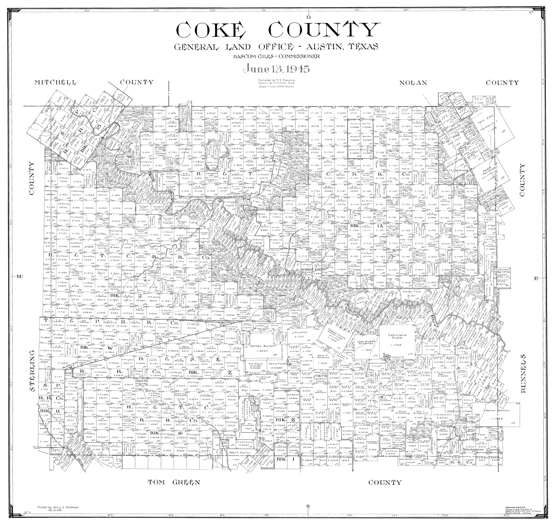
Coke County
-
Map/Doc
77240
-
Collection
General Map Collection
-
Object Dates
1945/6/13 (Creation Date)
-
People and Organizations
Tommye Buie (Draftsman)
Victor E. Sterzing (Compiler)
-
Counties
Coke
-
Subjects
County
-
Height x Width
38.7 x 40.9 inches
98.3 x 103.9 cm
Part of: General Map Collection
Flight Mission No. DIX-8P, Frame 62, Aransas County

Print $20.00
- Digital $50.00
Flight Mission No. DIX-8P, Frame 62, Aransas County
1956
Size 18.5 x 22.2 inches
Map/Doc 83893
Flight Mission No. CRK-3P, Frame 177, Refugio County

Print $20.00
- Digital $50.00
Flight Mission No. CRK-3P, Frame 177, Refugio County
1956
Size 18.6 x 22.4 inches
Map/Doc 86924

Nautical Chart 152-SC - Galveston Bay, Texas

Print $20.00
- Digital $50.00
Nautical Chart 152-SC - Galveston Bay, Texas
1972
Size 15.5 x 33.2 inches
Map/Doc 69890
Hudspeth County Rolled Sketch 18

Print $40.00
- Digital $50.00
Hudspeth County Rolled Sketch 18
1886
Size 15.7 x 105.0 inches
Map/Doc 9204
Glasscock County Working Sketch 8

Print $20.00
- Digital $50.00
Glasscock County Working Sketch 8
Size 42.7 x 10.3 inches
Map/Doc 62189

Ochiltree County Sketch File 7

Print $20.00
- Digital $50.00
Ochiltree County Sketch File 7
Size 14.5 x 26.1 inches
Map/Doc 42204
Flight Mission No. BRA-8M, Frame 73, Jefferson County

Print $20.00
- Digital $50.00
Flight Mission No. BRA-8M, Frame 73, Jefferson County
1953
Size 18.7 x 22.3 inches
Map/Doc 85593
Crane County Sketch File 3b

Print $20.00
- Digital $50.00
Crane County Sketch File 3b
1881
Size 11.9 x 38.6 inches
Map/Doc 11206
Culberson County Rolled Sketch 52

Print $20.00
- Digital $50.00
Culberson County Rolled Sketch 52
Size 18.7 x 24.8 inches
Map/Doc 5675
Lampasas County Working Sketch 6

Print $20.00
- Digital $50.00
Lampasas County Working Sketch 6
1950
Size 29.5 x 20.6 inches
Map/Doc 70283
You may also like
Jefferson County Working Sketch 27

Print $40.00
- Digital $50.00
Jefferson County Working Sketch 27
1977
Size 43.2 x 49.4 inches
Map/Doc 66570
Jefferson County Rolled Sketch 8

Print $54.00
- Digital $50.00
Jefferson County Rolled Sketch 8
1928
Size 36.0 x 46.6 inches
Map/Doc 9273
Red River County Working Sketch 55

Print $20.00
- Digital $50.00
Red River County Working Sketch 55
1971
Size 29.4 x 31.1 inches
Map/Doc 72038
Frio County Rolled Sketch 16

Print $20.00
- Digital $50.00
Frio County Rolled Sketch 16
1952
Size 38.4 x 40.7 inches
Map/Doc 8906
Working Sketch in Bailey County

Print $20.00
- Digital $50.00
Working Sketch in Bailey County
1920
Size 17.1 x 19.1 inches
Map/Doc 90185
Burnet County Rolled Sketch 5

Print $40.00
- Digital $50.00
Burnet County Rolled Sketch 5
1971
Size 36.5 x 49.6 inches
Map/Doc 8542
[Surveys in the Nacogdoches District, Rusk County]
![339, [Surveys in the Nacogdoches District, Rusk County], General Map Collection](https://historictexasmaps.com/wmedia_w700/maps/339.tif.jpg)
Print $2.00
- Digital $50.00
[Surveys in the Nacogdoches District, Rusk County]
Size 6.0 x 8.2 inches
Map/Doc 339
Flight Mission No. DQN-1K, Frame 117, Calhoun County

Print $20.00
- Digital $50.00
Flight Mission No. DQN-1K, Frame 117, Calhoun County
1953
Size 18.5 x 22.2 inches
Map/Doc 84183
Gregg County School Land League 2

Print $20.00
- Digital $50.00
Gregg County School Land League 2
Size 15.6 x 15.5 inches
Map/Doc 90613
Anton Independent School District Hockley and Lamb Counties, Texas

Print $20.00
- Digital $50.00
Anton Independent School District Hockley and Lamb Counties, Texas
Size 19.3 x 23.7 inches
Map/Doc 92215
Hutchinson County Sketch File 53

Print $2.00
- Digital $50.00
Hutchinson County Sketch File 53
2000
Size 11.2 x 8.8 inches
Map/Doc 27455
Parker County Sketch File 9

Print $4.00
- Digital $50.00
Parker County Sketch File 9
Size 8.1 x 10.0 inches
Map/Doc 33538