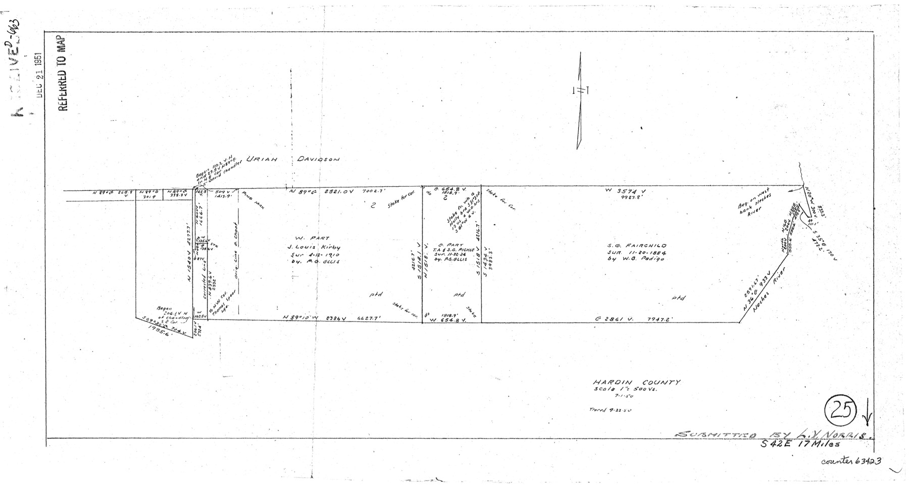
Hardin County Working Sketch 25
-
Map/Doc
63423
-
Collection
General Map Collection
-
Object Dates
7/1/1950 (Creation Date)
-
Counties
Hardin
-
Subjects
Surveying Working Sketch
-
Height x Width
10.8 x 20.1 inches
27.4 x 51.1 cm
-
Scale
1" = 500 varas
Part of: General Map Collection
Colorado County Working Sketch 35

Print $20.00
- Digital $50.00
Colorado County Working Sketch 35
Size 19.8 x 15.8 inches
Map/Doc 76065
Nueces County NRC Article 33.136 Sketch 24

Print $24.00
Nueces County NRC Article 33.136 Sketch 24
2024
Map/Doc 97424
Greer County Sketch File 5

Print $8.00
- Digital $50.00
Greer County Sketch File 5
1883
Size 10.0 x 15.6 inches
Map/Doc 24521
Rusk County Working Sketch 12

Print $20.00
- Digital $50.00
Rusk County Working Sketch 12
1979
Size 17.0 x 15.8 inches
Map/Doc 63647
Fisher County Working Sketch 2

Print $20.00
- Digital $50.00
Fisher County Working Sketch 2
1920
Size 23.0 x 18.2 inches
Map/Doc 69136
Texas, Espiritu Santo Bay

Print $40.00
- Digital $50.00
Texas, Espiritu Santo Bay
1934
Size 31.7 x 48.2 inches
Map/Doc 69996
Lynn County Boundary File 11

Print $44.00
- Digital $50.00
Lynn County Boundary File 11
Size 14.1 x 8.7 inches
Map/Doc 56745
Runnels County Rolled Sketch 50

Print $20.00
- Digital $50.00
Runnels County Rolled Sketch 50
Size 31.3 x 26.7 inches
Map/Doc 7535
Reagan County Rolled Sketch 26

Print $20.00
- Digital $50.00
Reagan County Rolled Sketch 26
1951
Size 32.7 x 42.7 inches
Map/Doc 9820
Flight Mission No. DIX-5P, Frame 144, Aransas County

Print $20.00
- Digital $50.00
Flight Mission No. DIX-5P, Frame 144, Aransas County
1956
Size 17.2 x 17.6 inches
Map/Doc 83805
[Travis Station Map - Tracks and Structures - Lands. San Antonio & Aransas Pass Railway Co.]
![62564, [Travis Station Map - Tracks and Structures - Lands. San Antonio & Aransas Pass Railway Co.], General Map Collection](https://historictexasmaps.com/wmedia_w700/maps/62564.tif.jpg)
Print $4.00
- Digital $50.00
[Travis Station Map - Tracks and Structures - Lands. San Antonio & Aransas Pass Railway Co.]
1919
Size 11.7 x 18.7 inches
Map/Doc 62564

You may also like
Sabine County Working Sketch 16

Print $20.00
- Digital $50.00
Sabine County Working Sketch 16
1984
Size 26.0 x 29.8 inches
Map/Doc 63687
Official Map of the City of Bryan from Actual Survey [East half]
![3203, Official Map of the City of Bryan from Actual Survey [East half], General Map Collection](https://historictexasmaps.com/wmedia_w700/maps/3203.tif.jpg)
Print $40.00
- Digital $50.00
Official Map of the City of Bryan from Actual Survey [East half]
1898
Size 52.3 x 27.4 inches
Map/Doc 3203
Harris County Working Sketch 71

Print $20.00
- Digital $50.00
Harris County Working Sketch 71
1957
Size 26.8 x 42.3 inches
Map/Doc 65963
Flight Mission No. DAH-9M, Frame 201, Orange County

Print $20.00
- Digital $50.00
Flight Mission No. DAH-9M, Frame 201, Orange County
1953
Size 18.6 x 22.5 inches
Map/Doc 86869
Mitchell County Sketch File 16b

Print $20.00
- Digital $50.00
Mitchell County Sketch File 16b
Size 28.7 x 36.8 inches
Map/Doc 10545
Brown County Rolled Sketch 2A

Print $20.00
- Digital $50.00
Brown County Rolled Sketch 2A
1984
Size 25.6 x 37.4 inches
Map/Doc 5350
Flight Mission No. DCL-6C, Frame 178, Kenedy County

Print $20.00
- Digital $50.00
Flight Mission No. DCL-6C, Frame 178, Kenedy County
1943
Size 18.7 x 22.4 inches
Map/Doc 85990
Ochiltree County Working Sketch 2

Print $20.00
- Digital $50.00
Ochiltree County Working Sketch 2
1959
Size 23.9 x 20.8 inches
Map/Doc 71315
Burleson County State Real Property Sketch 1

Print $80.00
- Digital $50.00
Burleson County State Real Property Sketch 1
2003
Size 37.0 x 53.6 inches
Map/Doc 81907
Map of Bastrop District

Print $20.00
- Digital $50.00
Map of Bastrop District
1847
Size 22.9 x 28.3 inches
Map/Doc 3275
General Highway Map, Willacy County, Texas

Print $20.00
General Highway Map, Willacy County, Texas
1961
Size 18.2 x 24.7 inches
Map/Doc 79711
Stonewall County

Print $20.00
- Digital $50.00
Stonewall County
1879
Size 22.7 x 19.1 inches
Map/Doc 4058