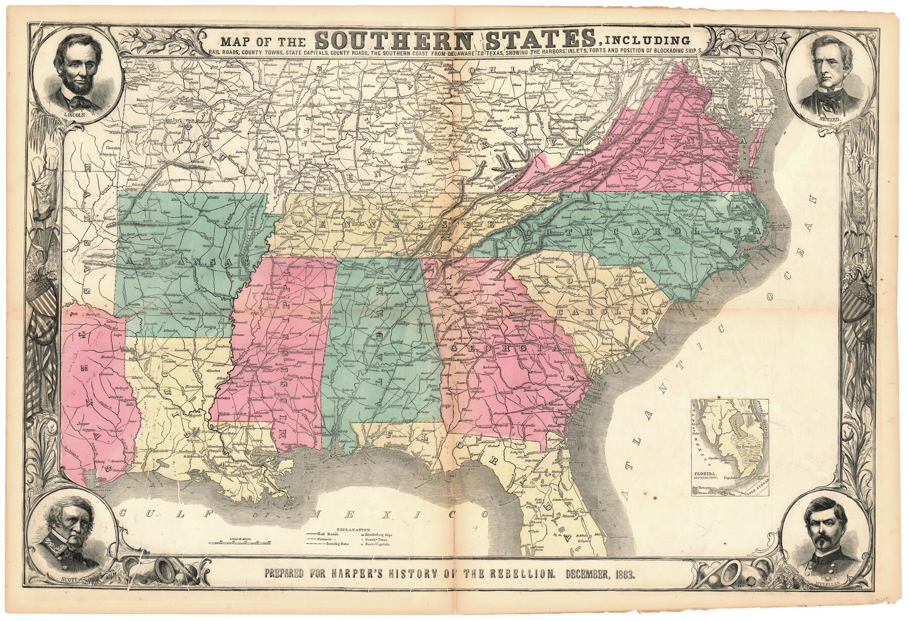
Map of the southern states, including rail roads, county towns, state capitals, county roads, the southern coast from Delaware to Texas, showing the harbors, inlets, forts and position of blockading ships
[Inset:] Florida, Southern Part
-
Map/Doc
96635
-
Collection
General Map Collection
-
Object Dates
12/1863 (Creation Date)
-
People and Organizations
Harper's Weekly (Publisher)
-
Subjects
Old Southwest
-
Height x Width
22.1 x 32.3 inches
56.1 x 82.0 cm
-
Medium
paper, etching/engraving/lithograph
-
Comments
Prepared for Harper's History of the Rebellion. To view multiple pictorial maps on verso, click the "Download PDF" link above.
Relief shown by hachures.
Inset map: Florida, southern part.
Includes portraits of Lincoln, Scott, Seward, and McClellan.
Views on verso: Balloon view of Fortress Monroe and Hampton Roads -- Balloon view of the seat of war -- Pictorial map of portions of Delaware, Maryland, Virginia, and North Carolina, with the coast line from Cape Henry to Fort Pickens.
Part of: General Map Collection
Limestone County Sketch File 19

Print $4.00
- Digital $50.00
Limestone County Sketch File 19
1922
Size 11.0 x 8.7 inches
Map/Doc 30193
Flight Mission No. BRA-7M, Frame 39, Jefferson County

Print $20.00
- Digital $50.00
Flight Mission No. BRA-7M, Frame 39, Jefferson County
1953
Size 18.7 x 22.5 inches
Map/Doc 85490
Galveston County NRC Article 33.136 Sketch 61

Print $140.00
- Digital $50.00
Galveston County NRC Article 33.136 Sketch 61
2009
Size 24.0 x 36.0 inches
Map/Doc 94824
Flight Mission No. CUG-3P, Frame 18, Kleberg County

Print $20.00
- Digital $50.00
Flight Mission No. CUG-3P, Frame 18, Kleberg County
1956
Size 18.5 x 22.3 inches
Map/Doc 86228
Moore County Rolled Sketch 14

Print $20.00
- Digital $50.00
Moore County Rolled Sketch 14
1981
Size 22.6 x 26.6 inches
Map/Doc 6830
Shackelford County Rolled Sketch 4A

Print $40.00
- Digital $50.00
Shackelford County Rolled Sketch 4A
1984
Size 35.2 x 48.7 inches
Map/Doc 9917
Reeves County Working Sketch 48

Print $20.00
- Digital $50.00
Reeves County Working Sketch 48
1974
Size 41.5 x 31.1 inches
Map/Doc 63491
Anderson County Sketch File 11

Print $6.00
- Digital $50.00
Anderson County Sketch File 11
1853
Size 8.7 x 6.6 inches
Map/Doc 12765
Sutton County Sketch File 33B

Print $20.00
- Digital $50.00
Sutton County Sketch File 33B
1934
Size 17.1 x 29.5 inches
Map/Doc 12386
Bosque County Sketch File 20

Print $4.00
- Digital $50.00
Bosque County Sketch File 20
1863
Size 11.8 x 7.7 inches
Map/Doc 14796
Madison County Rolled Sketch 1

Print $20.00
- Digital $50.00
Madison County Rolled Sketch 1
1966
Size 36.7 x 46.0 inches
Map/Doc 9485
Hutchinson County Working Sketch 6

Print $20.00
- Digital $50.00
Hutchinson County Working Sketch 6
1914
Size 20.2 x 29.0 inches
Map/Doc 66364
You may also like
Hamilton County Map

Print $40.00
- Digital $50.00
Hamilton County Map
1887
Size 38.2 x 54.4 inches
Map/Doc 16844
Upton County Working Sketch 39

Print $20.00
- Digital $50.00
Upton County Working Sketch 39
1958
Size 25.4 x 30.1 inches
Map/Doc 69535
[Surveys in Waller County]
![78367, [Surveys in Waller County], General Map Collection](https://historictexasmaps.com/wmedia_w700/maps/78367.tif.jpg)
Print $20.00
- Digital $50.00
[Surveys in Waller County]
Size 21.5 x 28.7 inches
Map/Doc 78367
Flight Mission No. BQY-15M, Frame 7, Harris County

Print $20.00
- Digital $50.00
Flight Mission No. BQY-15M, Frame 7, Harris County
1953
Size 18.5 x 22.4 inches
Map/Doc 85305

Military Reconnaissance [showing forts along Rio Grande near Matamoros]
![72912, Military Reconnaissance [showing forts along Rio Grande near Matamoros], General Map Collection](https://historictexasmaps.com/wmedia_w700/maps/72912.tif.jpg)
Print $20.00
- Digital $50.00
Military Reconnaissance [showing forts along Rio Grande near Matamoros]
1846
Size 18.3 x 27.0 inches
Map/Doc 72912
Map of Lands surveyed for the Deaf & Dumb Asylum on the head waters of the Leon River

Print $20.00
- Digital $50.00
Map of Lands surveyed for the Deaf & Dumb Asylum on the head waters of the Leon River
1857
Size 13.3 x 17.1 inches
Map/Doc 2209
Chambers County Rolled Sketch 21

Print $20.00
- Digital $50.00
Chambers County Rolled Sketch 21
1940
Size 40.9 x 41.0 inches
Map/Doc 8589

Map showing lands surveyed by Sylvan Sanders in the Southwestern Part of Jack County, Texas for Buttram Petroleum Corporation

Print $20.00
- Digital $50.00
Map showing lands surveyed by Sylvan Sanders in the Southwestern Part of Jack County, Texas for Buttram Petroleum Corporation
1926
Size 29.3 x 25.6 inches
Map/Doc 92159
Flight Mission No. CUG-1P, Frame 171, Kleberg County

Print $20.00
- Digital $50.00
Flight Mission No. CUG-1P, Frame 171, Kleberg County
1956
Size 18.5 x 22.1 inches
Map/Doc 86178
Webb County Rolled Sketch 78

Print $20.00
- Digital $50.00
Webb County Rolled Sketch 78
2011
Size 33.1 x 24.6 inches
Map/Doc 90052