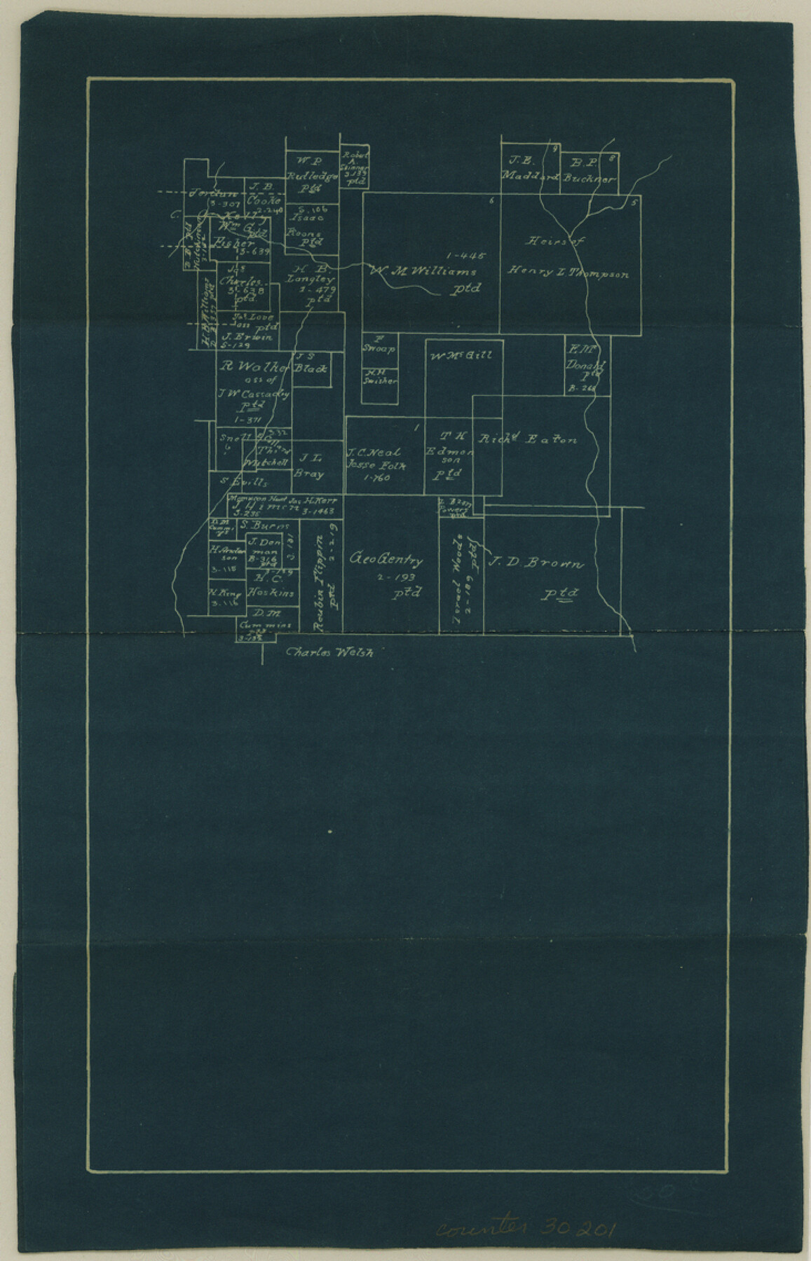
Limestone County Sketch File 22
[Sketch of surveys around the Jessie Folk survey, southwest of Groesbeck]
-
Map/Doc
30201
-
Collection
General Map Collection
-
Counties
Limestone Falls
-
Subjects
Surveying Sketch File
-
Height x Width
11.4 x 7.3 inches
29.0 x 18.5 cm
-
Medium
blueprint/diazo
Part of: General Map Collection
Sherman County Sketch File C

Print $54.00
- Digital $50.00
Sherman County Sketch File C
1918
Size 11.4 x 8.8 inches
Map/Doc 36694
Galveston County NRC Article 33.136 Sketch 13

Print $20.00
- Digital $50.00
Galveston County NRC Article 33.136 Sketch 13
2002
Size 17.9 x 22.4 inches
Map/Doc 77044
Bosque County Sketch File 19

Print $4.00
- Digital $50.00
Bosque County Sketch File 19
1863
Size 12.9 x 6.2 inches
Map/Doc 14794
Uvalde County Working Sketch 24

Print $20.00
- Digital $50.00
Uvalde County Working Sketch 24
1954
Size 21.7 x 23.3 inches
Map/Doc 72094
Flight Mission No. DCL-6C, Frame 174, Kenedy County

Print $20.00
- Digital $50.00
Flight Mission No. DCL-6C, Frame 174, Kenedy County
1943
Size 18.7 x 22.3 inches
Map/Doc 85986

Map of The Surveyed Part of Peters Colony Texas

Print $40.00
- Digital $50.00
Map of The Surveyed Part of Peters Colony Texas
1852
Size 56.5 x 41.0 inches
Map/Doc 1966
Val Verde Co.

Print $20.00
- Digital $50.00
Val Verde Co.
1908
Size 39.8 x 38.7 inches
Map/Doc 63100
Map of Dallas County

Print $20.00
- Digital $50.00
Map of Dallas County
1861
Size 23.5 x 20.0 inches
Map/Doc 3467
Presidio County Sketch File 113

Print $6.00
- Digital $50.00
Presidio County Sketch File 113
Size 11.9 x 8.8 inches
Map/Doc 34829
Comanche County Sketch File 6

Print $4.00
- Digital $50.00
Comanche County Sketch File 6
1854
Size 12.7 x 8.4 inches
Map/Doc 19061
Hays County Working Sketch 11

Print $20.00
- Digital $50.00
Hays County Working Sketch 11
1950
Size 22.7 x 33.1 inches
Map/Doc 66085
You may also like
Brazoria County NRC Article 33.136 Sketch 13

Print $42.00
- Digital $50.00
Brazoria County NRC Article 33.136 Sketch 13
2012
Size 36.0 x 23.0 inches
Map/Doc 95069
Hardin County Working Sketch 32

Print $20.00
- Digital $50.00
Hardin County Working Sketch 32
1978
Size 41.7 x 38.0 inches
Map/Doc 63430
[North Part of Block G]
![92637, [North Part of Block G], Twichell Survey Records](https://historictexasmaps.com/wmedia_w700/maps/92637-1.tif.jpg)
Print $20.00
- Digital $50.00
[North Part of Block G]
Size 24.1 x 19.7 inches
Map/Doc 92637
From Citizens of Red River County for the Creation of a New County to be Called Aurora, December 3, 1840

Print $20.00
From Citizens of Red River County for the Creation of a New County to be Called Aurora, December 3, 1840
2020
Size 19.8 x 21.7 inches
Map/Doc 96391
United States - Gulf Coast - From Latitude 26° 33' to the Rio Grande Texas

Print $20.00
- Digital $50.00
United States - Gulf Coast - From Latitude 26° 33' to the Rio Grande Texas
1919
Size 27.5 x 18.4 inches
Map/Doc 72854
Oso Creek, Cudahay Field (P-3) Sheet

Print $6.00
- Digital $50.00
Oso Creek, Cudahay Field (P-3) Sheet
1942
Size 30.6 x 33.8 inches
Map/Doc 65098
Hutchinson County Rolled Sketch 44-12

Print $20.00
- Digital $50.00
Hutchinson County Rolled Sketch 44-12
2002
Size 24.0 x 36.0 inches
Map/Doc 77548
Montague County Working Sketch 22

Print $20.00
- Digital $50.00
Montague County Working Sketch 22
1952
Size 29.5 x 24.6 inches
Map/Doc 71088
Montgomery County

Print $20.00
- Digital $50.00
Montgomery County
1861
Size 18.4 x 22.3 inches
Map/Doc 3890
Matagorda County Sketch File 24

Print $10.00
- Digital $50.00
Matagorda County Sketch File 24
1900
Size 8.2 x 5.1 inches
Map/Doc 30787
The Republic County of Bexar. December 29, 1845

Print $20.00
The Republic County of Bexar. December 29, 1845
2020
Size 24.6 x 21.6 inches
Map/Doc 96101
Map of Matagorda County
Print $20.00
- Digital $50.00
Map of Matagorda County
1883
Size 29.4 x 26.6 inches
Map/Doc 3840