Edwards County Sketch File 21
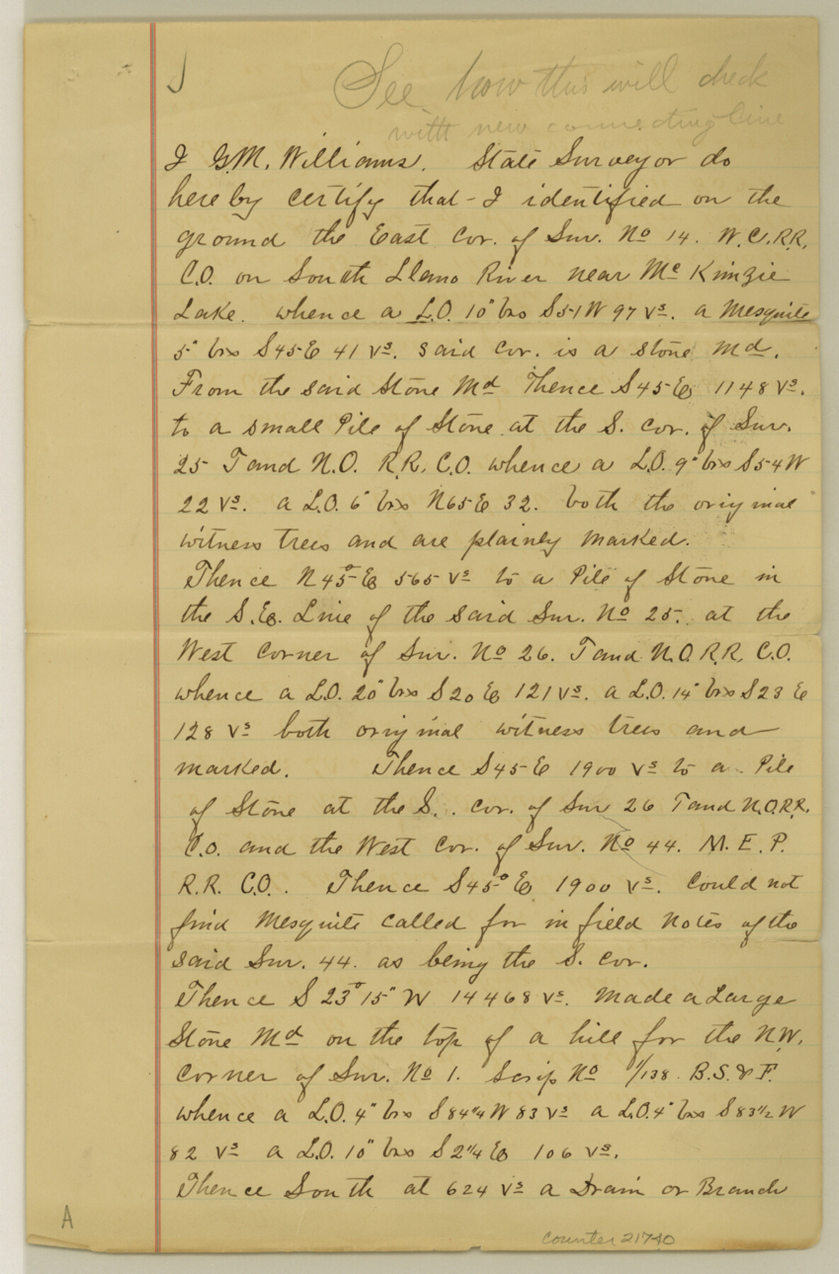
[Statement regarding the east corner of survey 14, W. C. RR. Co.]
-
Map/Doc
21740
-
Collection
General Map Collection
-
Object Dates
1889/1/30 (Creation Date)
1888/8/17 (Survey Date)
-
People and Organizations
George M. Williams (Surveyor/Engineer)
-
Counties
Edwards
-
Subjects
Surveying Sketch File
-
Height x Width
12.9 x 8.5 inches
32.8 x 21.6 cm
-
Medium
paper, manuscript
-
Features
South Llano River
McKenzie Lake
Part of: General Map Collection
Reeves County Working Sketch 1

Print $40.00
- Digital $50.00
Reeves County Working Sketch 1
Size 48.6 x 38.2 inches
Map/Doc 63443
Plat Showing Theoretical Original City Limits of Corpus Christi

Print $20.00
- Digital $50.00
Plat Showing Theoretical Original City Limits of Corpus Christi
Size 41.3 x 41.7 inches
Map/Doc 4838
Zapata County Rolled Sketch 12 1/2

Print $40.00
- Digital $50.00
Zapata County Rolled Sketch 12 1/2
1917
Size 53.1 x 38.8 inches
Map/Doc 10167
Ector County Boundary File 4

Print $4.00
- Digital $50.00
Ector County Boundary File 4
Size 13.3 x 8.2 inches
Map/Doc 52845
Tyler County Rolled Sketch 9

Print $20.00
- Digital $50.00
Tyler County Rolled Sketch 9
Size 43.3 x 25.6 inches
Map/Doc 8059
Harrison County State Real Property Sketch 1

Print $20.00
- Digital $50.00
Harrison County State Real Property Sketch 1
1986
Size 24.2 x 25.4 inches
Map/Doc 61666
Starr County Sketch File 36

Print $26.00
- Digital $50.00
Starr County Sketch File 36
1939
Size 14.3 x 8.7 inches
Map/Doc 36977
Wise County Working Sketch 27

Print $20.00
- Digital $50.00
Wise County Working Sketch 27
1988
Size 28.0 x 37.2 inches
Map/Doc 72641
Nueces County Sketch File 41

Print $8.00
- Digital $50.00
Nueces County Sketch File 41
Size 11.1 x 8.6 inches
Map/Doc 32629
Glasscock County Rolled Sketch 1

Print $20.00
- Digital $50.00
Glasscock County Rolled Sketch 1
1906
Size 37.3 x 33.6 inches
Map/Doc 9055
Floyd County Rolled Sketch 8

Print $20.00
- Digital $50.00
Floyd County Rolled Sketch 8
1947
Size 29.6 x 19.9 inches
Map/Doc 5882
Lubbock County Boundary File 5

Print $2.00
- Digital $50.00
Lubbock County Boundary File 5
Size 7.2 x 8.2 inches
Map/Doc 56493
You may also like
Zapata County Working Sketch 16

Print $20.00
- Digital $50.00
Zapata County Working Sketch 16
1969
Size 26.1 x 28.3 inches
Map/Doc 62067
Winkler County Working Sketch 15

Print $20.00
- Digital $50.00
Winkler County Working Sketch 15
1964
Size 29.2 x 30.5 inches
Map/Doc 72609
Houston County Working Sketch 33

Print $40.00
- Digital $50.00
Houston County Working Sketch 33
1987
Size 37.6 x 58.7 inches
Map/Doc 66263
Gaines County Sketch File 22

Print $20.00
- Digital $50.00
Gaines County Sketch File 22
1962
Size 18.1 x 23.4 inches
Map/Doc 11528
Howard County Boundary File 3a

Print $62.00
- Digital $50.00
Howard County Boundary File 3a
Size 3.9 x 8.7 inches
Map/Doc 55155
Harris County Sketch File 1

Print $20.00
- Digital $50.00
Harris County Sketch File 1
Size 14.8 x 12.6 inches
Map/Doc 25332
Yoakum County

Print $20.00
- Digital $50.00
Yoakum County
1902
Size 46.1 x 36.6 inches
Map/Doc 63138
[Surveys in Austin's Colony along the Navasota River and Ten Mile Creek]
![80, [Surveys in Austin's Colony along the Navasota River and Ten Mile Creek], General Map Collection](https://historictexasmaps.com/wmedia_w700/maps/80.tif.jpg)
Print $20.00
- Digital $50.00
[Surveys in Austin's Colony along the Navasota River and Ten Mile Creek]
1821
Size 29.2 x 18.0 inches
Map/Doc 80
Brewster County Working Sketch 2

Print $20.00
- Digital $50.00
Brewster County Working Sketch 2
1907
Size 29.0 x 26.4 inches
Map/Doc 67535
Irion County Boundary File 1a

Print $40.00
- Digital $50.00
Irion County Boundary File 1a
Size 33.5 x 9.3 inches
Map/Doc 55325
Texas, Espiritu Santo Bay

Print $40.00
- Digital $50.00
Texas, Espiritu Santo Bay
1934
Size 31.7 x 48.2 inches
Map/Doc 69996
Presidio County Sketch File 50

Print $8.00
- Digital $50.00
Presidio County Sketch File 50
1919
Size 13.3 x 8.8 inches
Map/Doc 34586