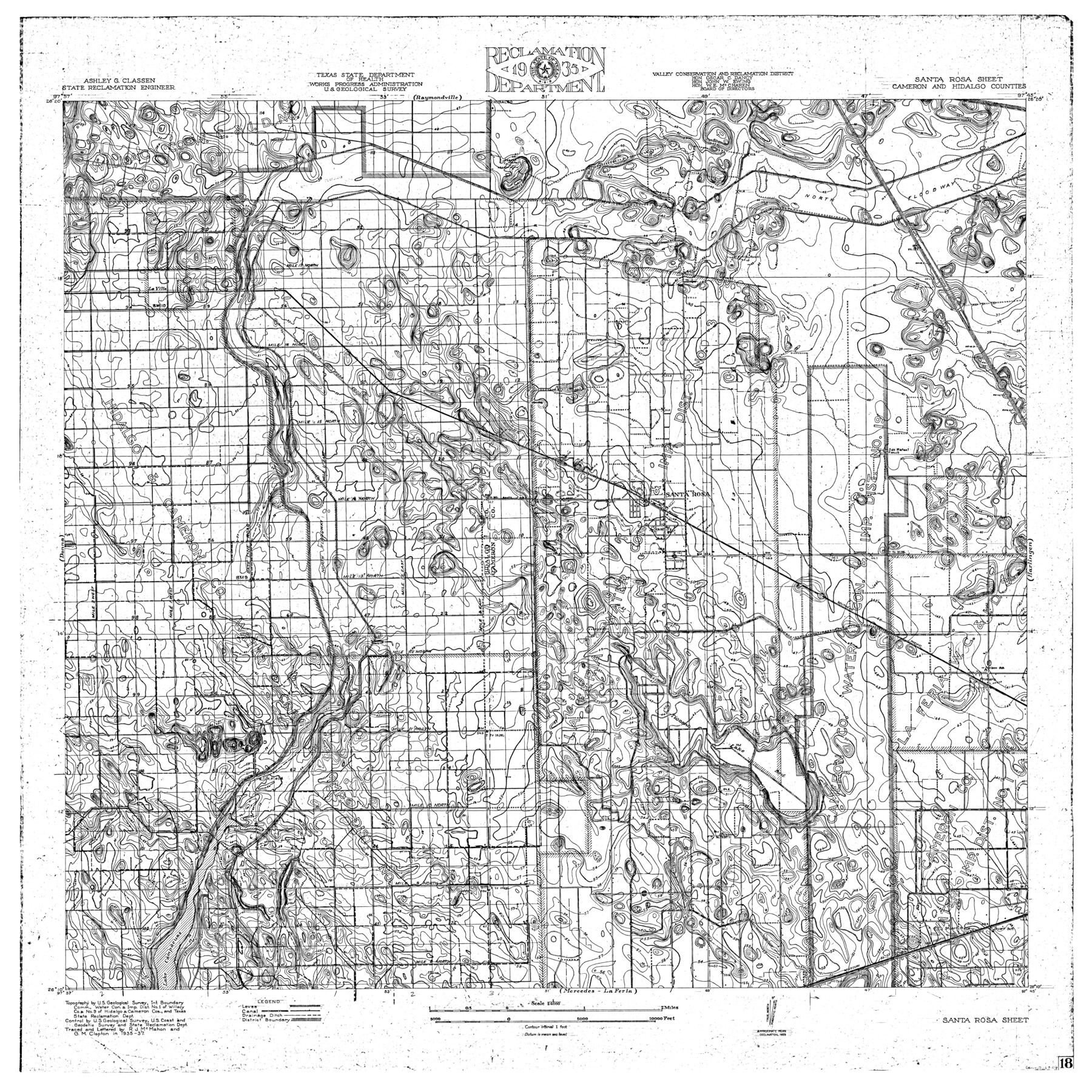
Rio Grande, Santa Rosa Sheet
-
Map/Doc
65116
-
Collection
General Map Collection
-
Object Dates
1937 (Creation Date)
-
People and Organizations
Texas State Reclamation Department (Publisher)
G.M. Clopton (Draftsman)
R.J. McMahon (Compiler)
G.M. Clopton (Compiler)
R.J. McMahon (Draftsman)
-
Counties
Cameron Hidalgo
-
Subjects
River Surveys Topographic
-
Height x Width
37.3 x 37.3 inches
94.7 x 94.7 cm
-
Comments
Santa Rosa Sheet located south of the Raymondville Sheet, north of the Mercedes - La Feria Sheet, east of the Donna Sheet and west of the Harlingen Sheet.
Part of: General Map Collection
Lipscomb County

Print $20.00
- Digital $50.00
Lipscomb County
1889
Size 23.5 x 18.5 inches
Map/Doc 3817
Map of Parmer County

Print $20.00
- Digital $50.00
Map of Parmer County
1900
Size 47.8 x 41.3 inches
Map/Doc 16786
Pecos County Rolled Sketch 59

Print $20.00
- Digital $50.00
Pecos County Rolled Sketch 59
1922
Size 16.6 x 17.0 inches
Map/Doc 7231
Real County Working Sketch 88

Print $20.00
- Digital $50.00
Real County Working Sketch 88
1989
Size 23.9 x 27.0 inches
Map/Doc 71980
Childress County Working Sketch 2
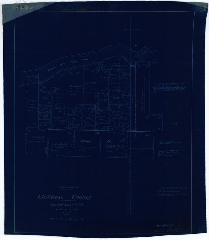
Print $20.00
- Digital $50.00
Childress County Working Sketch 2
1907
Size 17.1 x 14.9 inches
Map/Doc 68018
Hansford County Rolled Sketch 1

Print $20.00
- Digital $50.00
Hansford County Rolled Sketch 1
1979
Size 22.3 x 17.6 inches
Map/Doc 6064
Cameron County NRC Article 33.136 Sketch 3

Print $7.00
- Digital $50.00
Cameron County NRC Article 33.136 Sketch 3
2003
Size 11.2 x 17.3 inches
Map/Doc 78540
Dimmit County Working Sketch 17

Print $20.00
- Digital $50.00
Dimmit County Working Sketch 17
1943
Size 27.4 x 24.7 inches
Map/Doc 68678
Brewster County Sketch File FN-31

Print $4.00
- Digital $50.00
Brewster County Sketch File FN-31
1975
Size 11.3 x 8.8 inches
Map/Doc 15852
Hemphill County Sketch File 9

Print $26.00
- Digital $50.00
Hemphill County Sketch File 9
1955
Size 11.0 x 8.8 inches
Map/Doc 26312
Swisher County Rolled Sketch 6

Print $20.00
- Digital $50.00
Swisher County Rolled Sketch 6
1941
Size 43.0 x 27.6 inches
Map/Doc 7907
Map of Brassos [sic] & Bosque Surveys
![146, Map of Brassos [sic] & Bosque Surveys, General Map Collection](https://historictexasmaps.com/wmedia_w700/maps/146.tif.jpg)
Print $20.00
- Digital $50.00
Map of Brassos [sic] & Bosque Surveys
1841
Size 27.7 x 18.9 inches
Map/Doc 146
You may also like
Flight Mission No. DQN-3K, Frame 8, Calhoun County

Print $20.00
- Digital $50.00
Flight Mission No. DQN-3K, Frame 8, Calhoun County
1953
Size 18.5 x 22.1 inches
Map/Doc 84340
Hardeman County Sketch File 9

Print $20.00
- Digital $50.00
Hardeman County Sketch File 9
1884
Size 27.7 x 30.1 inches
Map/Doc 11624
Crane County Working Sketch 1

Print $20.00
- Digital $50.00
Crane County Working Sketch 1
1906
Size 30.5 x 27.0 inches
Map/Doc 68278
Map of the United States with the contiguous British & Spanish Possessions compiled from the latest & best authorities

Print $40.00
- Digital $50.00
Map of the United States with the contiguous British & Spanish Possessions compiled from the latest & best authorities
1818
Size 36.9 x 59.5 inches
Map/Doc 93843
Bandera County Working Sketch 8

Print $20.00
- Digital $50.00
Bandera County Working Sketch 8
1920
Size 16.6 x 20.8 inches
Map/Doc 67601
El Paso County Rolled Sketch RJ

Print $40.00
- Digital $50.00
El Paso County Rolled Sketch RJ
1919
Size 56.7 x 27.2 inches
Map/Doc 8865
Harris County Rolled Sketch 96C

Print $3.00
- Digital $50.00
Harris County Rolled Sketch 96C
Size 10.5 x 10.5 inches
Map/Doc 10653
Presidio County Sketch File 116

Print $86.00
- Digital $50.00
Presidio County Sketch File 116
1993
Size 11.4 x 8.7 inches
Map/Doc 34842
Vicinity of San Luis Pass, Galveston Island, Texas

Print $40.00
- Digital $50.00
Vicinity of San Luis Pass, Galveston Island, Texas
1933
Size 37.1 x 57.8 inches
Map/Doc 69943
Coke County Working Sketch 7
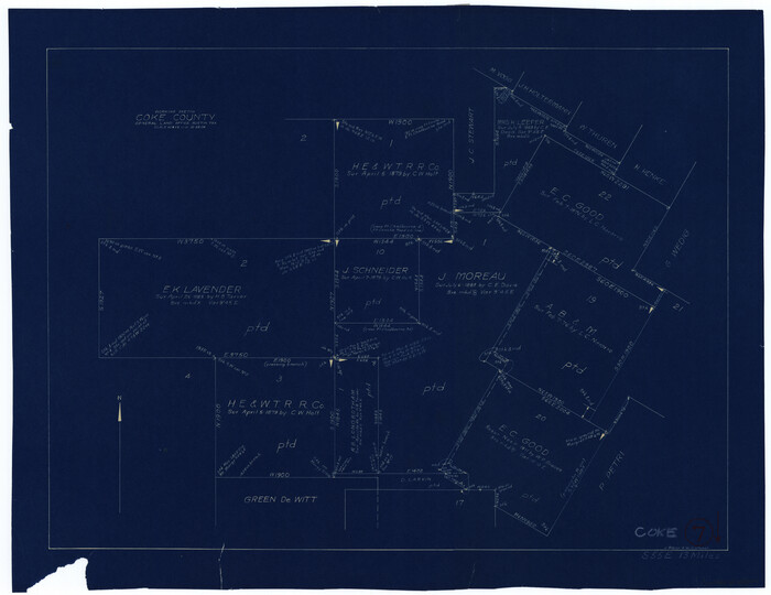
Print $20.00
- Digital $50.00
Coke County Working Sketch 7
1924
Size 15.8 x 20.4 inches
Map/Doc 68044
Flight Mission No. DQO-7K, Frame 109, Galveston County

Print $20.00
- Digital $50.00
Flight Mission No. DQO-7K, Frame 109, Galveston County
1952
Size 18.7 x 22.4 inches
Map/Doc 85124
Map of Martin County

Print $20.00
- Digital $50.00
Map of Martin County
1900
Size 41.9 x 35.0 inches
Map/Doc 4789