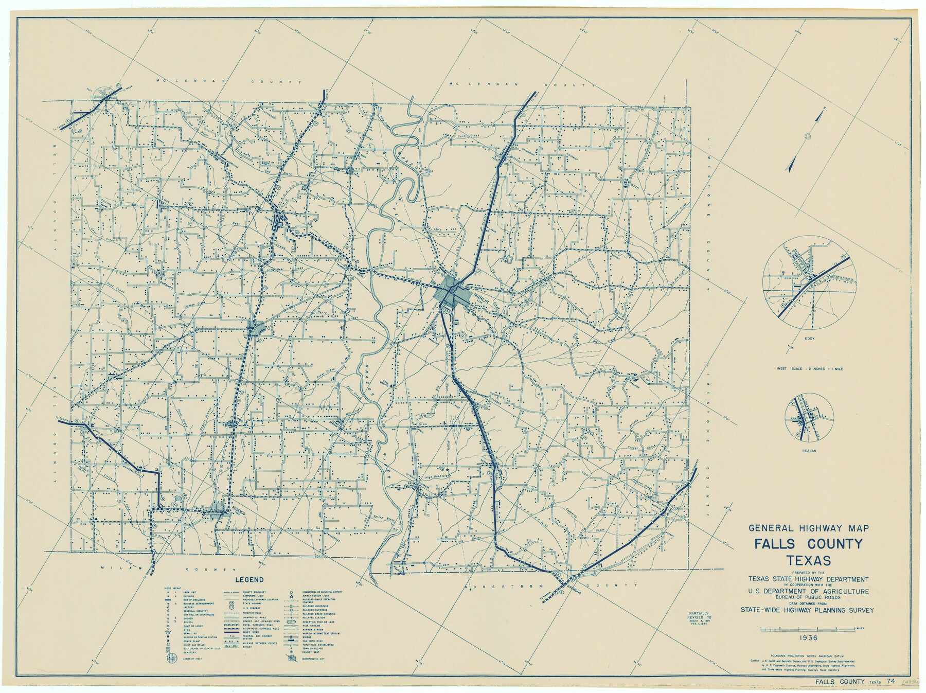
General Highway Map, Falls County, Texas
-
Map/Doc
79088
-
Collection
Texas State Library and Archives
-
Object Dates
1940 (Creation Date)
-
People and Organizations
Texas State Highway Department (Publisher)
-
Counties
Falls
-
Subjects
County
-
Height x Width
18.5 x 24.7 inches
47.0 x 62.7 cm
-
Comments
Prints available courtesy of the Texas State Library and Archives.
More info can be found here: TSLAC Map 04857
Part of: Texas State Library and Archives
General Highway Map, Hill County, Texas

Print $20.00
General Highway Map, Hill County, Texas
1940
Size 25.0 x 18.6 inches
Map/Doc 79129
General Highway Map, Yoakum County, Texas

Print $20.00
General Highway Map, Yoakum County, Texas
1961
Size 18.2 x 24.7 inches
Map/Doc 79719
General Highway Map. Detail of Cities and Towns in Collin County, Texas

Print $20.00
General Highway Map. Detail of Cities and Towns in Collin County, Texas
1961
Size 18.2 x 24.8 inches
Map/Doc 79414
General Highway Map, Waller County, Texas

Print $20.00
General Highway Map, Waller County, Texas
1961
Size 24.9 x 18.2 inches
Map/Doc 79700
General Highway Map, Sterling County, Texas

Print $20.00
General Highway Map, Sterling County, Texas
1940
Size 24.9 x 18.4 inches
Map/Doc 79248
Map of Texas with Parts of the Adjoining States

Print $20.00
Map of Texas with Parts of the Adjoining States
1836
Size 29.5 x 23.6 inches
Map/Doc 76193
Partial View of Austin, Texas

Print $20.00
Partial View of Austin, Texas
1895
Size 28.4 x 41.8 inches
Map/Doc 76205

Stremme General Land Office Drawings, front door

Print $20.00
Stremme General Land Office Drawings, front door
Size 27.4 x 21.9 inches
Map/Doc 79737
General Highway Map, Calhoun County, Texas

Print $20.00
General Highway Map, Calhoun County, Texas
1940
Size 18.5 x 25.3 inches
Map/Doc 79036
New Map of the State of Texas compiled from the latest authorities

Print $20.00
New Map of the State of Texas compiled from the latest authorities
1877
Size 19.1 x 21.4 inches
Map/Doc 79300
Mitchell's Travellers Guide Through the United States. A Map of the Roads, Distances, Steam Boat, and Canal Routes etc.

Print $20.00
Mitchell's Travellers Guide Through the United States. A Map of the Roads, Distances, Steam Boat, and Canal Routes etc.
1835
Size 18.0 x 22.7 inches
Map/Doc 79723
You may also like
St. Louis Southwestern Railway of Texas

Print $40.00
- Digital $50.00
St. Louis Southwestern Railway of Texas
1905
Size 15.3 x 87.2 inches
Map/Doc 64445
Morris County Rolled Sketch 2A

Print $20.00
- Digital $50.00
Morris County Rolled Sketch 2A
Size 24.2 x 19.1 inches
Map/Doc 10249
Menard County Boundary File 13

Print $32.00
- Digital $50.00
Menard County Boundary File 13
Size 8.9 x 9.4 inches
Map/Doc 57121
Map of Texas with population and location of principal towns and cities, according to latest reliable statistics

Print $20.00
- Digital $50.00
Map of Texas with population and location of principal towns and cities, according to latest reliable statistics
1906
Size 18.9 x 22.4 inches
Map/Doc 95869
Cass County Sketch File 23

Print $10.00
- Digital $50.00
Cass County Sketch File 23
1936
Size 14.1 x 8.6 inches
Map/Doc 17435
Map of Shelby County

Print $20.00
- Digital $50.00
Map of Shelby County
1863
Size 18.6 x 22.3 inches
Map/Doc 4031
Kinney County Working Sketch 49

Print $20.00
- Digital $50.00
Kinney County Working Sketch 49
1980
Size 19.9 x 25.6 inches
Map/Doc 70231
Potter County Sketch File 10

Print $40.00
- Digital $50.00
Potter County Sketch File 10
Size 58.9 x 37.7 inches
Map/Doc 10576
Brazoria County Working Sketch 16

Print $20.00
- Digital $50.00
Brazoria County Working Sketch 16
1943
Size 35.3 x 32.3 inches
Map/Doc 67501
Midland County Working Sketch 19

Print $20.00
- Digital $50.00
Midland County Working Sketch 19
1953
Size 29.9 x 24.7 inches
Map/Doc 70999
General Highway Map, Floyd County, Texas

Print $20.00
General Highway Map, Floyd County, Texas
1940
Size 25.1 x 18.7 inches
Map/Doc 79091
