Randall County Rolled Sketch 2
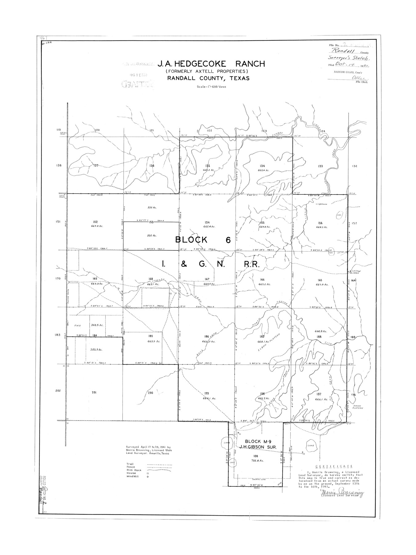
J.A. Hedgecoke Ranch (formerly Axtell Properties), Randall County, Texas
-
Map/Doc
7422
-
Collection
General Map Collection
-
Object Dates
9/16/1941 (Creation Date)
10/14/1941 (File Date)
-
People and Organizations
Morris Browning (Surveyor/Engineer)
-
Counties
Randall
-
Subjects
Surveying Rolled Sketch
-
Height x Width
31.9 x 23.9 inches
81.0 x 60.7 cm
-
Scale
1" = 600 varas
Part of: General Map Collection
Live Oak County Working Sketch 28

Print $20.00
- Digital $50.00
Live Oak County Working Sketch 28
1982
Size 33.3 x 21.1 inches
Map/Doc 70613
McCulloch County Rolled Sketch 6

Print $20.00
- Digital $50.00
McCulloch County Rolled Sketch 6
1982
Size 27.9 x 33.9 inches
Map/Doc 6717
Reagan County Sketch File 30

Print $20.00
- Digital $50.00
Reagan County Sketch File 30
1951
Size 27.4 x 20.3 inches
Map/Doc 12226
Flight Mission No. BRE-1P, Frame 33, Nueces County

Print $20.00
- Digital $50.00
Flight Mission No. BRE-1P, Frame 33, Nueces County
1956
Size 18.5 x 22.2 inches
Map/Doc 86629
Harbor Pass and Bar at Brazos Santiago, Texas

Print $20.00
- Digital $50.00
Harbor Pass and Bar at Brazos Santiago, Texas
1871
Size 18.2 x 26.3 inches
Map/Doc 72985
Flight Mission No. DAG-17K, Frame 124, Matagorda County

Print $20.00
- Digital $50.00
Flight Mission No. DAG-17K, Frame 124, Matagorda County
1952
Size 18.6 x 22.3 inches
Map/Doc 86344
Montgomery County Sketch File 8

Print $4.00
- Digital $50.00
Montgomery County Sketch File 8
1862
Size 12.2 x 8.2 inches
Map/Doc 31793
Flight Mission No. BRE-1P, Frame 104, Nueces County

Print $20.00
- Digital $50.00
Flight Mission No. BRE-1P, Frame 104, Nueces County
1956
Size 18.4 x 22.2 inches
Map/Doc 86675
Hunt County Working Sketch 10

Print $20.00
- Digital $50.00
Hunt County Working Sketch 10
1959
Size 31.5 x 42.8 inches
Map/Doc 66357
Calhoun County Working Sketch 1

Print $20.00
- Digital $50.00
Calhoun County Working Sketch 1
Size 28.3 x 33.7 inches
Map/Doc 67816
San Jacinto County Working Sketch 13

Print $20.00
- Digital $50.00
San Jacinto County Working Sketch 13
1935
Size 25.0 x 18.8 inches
Map/Doc 63726
Angelina County Sketch File 21

Print $6.00
- Digital $50.00
Angelina County Sketch File 21
1883
Size 8.8 x 4.0 inches
Map/Doc 13038
You may also like
Culberson County Working Sketch 47

Print $20.00
- Digital $50.00
Culberson County Working Sketch 47
1971
Size 25.7 x 36.5 inches
Map/Doc 68501
Culberson County Sketch File 44

Print $57.00
- Digital $50.00
Culberson County Sketch File 44
1968
Size 11.4 x 8.9 inches
Map/Doc 20331
Delta County Working Sketch Graphic Index

Print $20.00
- Digital $50.00
Delta County Working Sketch Graphic Index
1942
Size 25.3 x 39.2 inches
Map/Doc 76520
Angelina County Working Sketch 1

Print $20.00
- Digital $50.00
Angelina County Working Sketch 1
Size 17.3 x 17.8 inches
Map/Doc 67081
Map of Ellis County

Print $20.00
- Digital $50.00
Map of Ellis County
1889
Size 38.9 x 47.7 inches
Map/Doc 4941
Kaufman County, 1887

Print $20.00
- Digital $50.00
Kaufman County, 1887
1887
Size 42.6 x 46.1 inches
Map/Doc 89701
Flight Mission No. CRE-2R, Frame 80, Jackson County

Print $20.00
- Digital $50.00
Flight Mission No. CRE-2R, Frame 80, Jackson County
1956
Size 18.7 x 22.3 inches
Map/Doc 85352
Concho, San Saba & Llano Valley Railway, Sterling City Branch, Texas. Right of Way and Track Map

Print $40.00
- Digital $50.00
Concho, San Saba & Llano Valley Railway, Sterling City Branch, Texas. Right of Way and Track Map
1910
Size 17.9 x 120.8 inches
Map/Doc 64436
Hutchinson County Rolled Sketch 44-17

Print $20.00
- Digital $50.00
Hutchinson County Rolled Sketch 44-17
2002
Size 24.0 x 36.0 inches
Map/Doc 77553
[Right of Way & Track Map, The Texas & Pacific Ry. Co. Main Line]
![64686, [Right of Way & Track Map, The Texas & Pacific Ry. Co. Main Line], General Map Collection](https://historictexasmaps.com/wmedia_w700/maps/64686.tif.jpg)
Print $20.00
- Digital $50.00
[Right of Way & Track Map, The Texas & Pacific Ry. Co. Main Line]
Size 11.0 x 19.0 inches
Map/Doc 64686
Lavaca County Rolled Sketch 6

Print $20.00
- Digital $50.00
Lavaca County Rolled Sketch 6
1986
Size 44.8 x 33.9 inches
Map/Doc 10290
Clay County Sketch File 41

Print $6.00
- Digital $50.00
Clay County Sketch File 41
1949
Size 14.2 x 8.6 inches
Map/Doc 18482