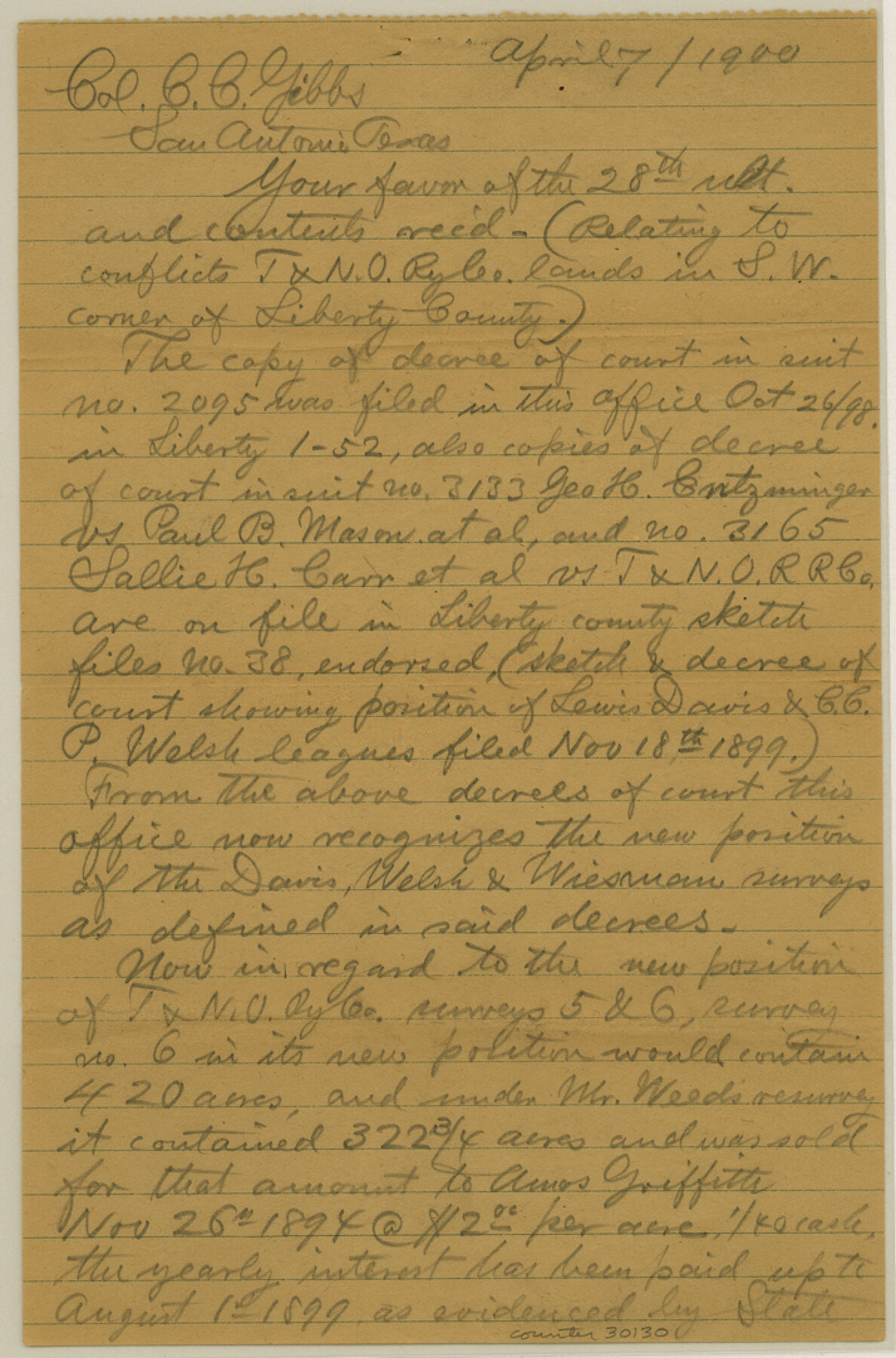
Liberty County Sketch File 66
[Letters regarding T. & N. O. RR. Co. surveys in the southwest corner of county]
-
Map/Doc
30130
-
Collection
General Map Collection
-
Object Dates
5/19/1900 (Creation Date)
11/30/1984 (File Date)
4/7/1900 (Correspondence Date)
5/19/1900 (Correspondence Date)
-
Counties
Liberty
-
Subjects
Surveying Sketch File
-
Height x Width
10.8 x 7.1 inches
27.4 x 18.0 cm
-
Medium
paper, manuscript
Part of: General Map Collection
Kendall County Working Sketch 2

Print $20.00
- Digital $50.00
Kendall County Working Sketch 2
1941
Size 28.6 x 21.1 inches
Map/Doc 66674
Hamilton County Sketch File 15

Print $2.00
- Digital $50.00
Hamilton County Sketch File 15
1882
Size 8.0 x 11.8 inches
Map/Doc 24941
Val Verde County Sketch File 11

Print $8.00
- Digital $50.00
Val Verde County Sketch File 11
1972
Size 11.3 x 8.9 inches
Map/Doc 39110
Culberson County Rolled Sketch 14

Print $20.00
- Digital $50.00
Culberson County Rolled Sketch 14
1902
Size 35.3 x 34.6 inches
Map/Doc 8743
Brazoria County Rolled Sketch 39

Print $20.00
- Digital $50.00
Brazoria County Rolled Sketch 39
1949
Size 22.8 x 34.8 inches
Map/Doc 5174
Map of Hamilton County

Print $20.00
- Digital $50.00
Map of Hamilton County
1863
Size 22.8 x 25.8 inches
Map/Doc 3621
Edwards County Working Sketch 111

Print $40.00
- Digital $50.00
Edwards County Working Sketch 111
1972
Size 58.1 x 30.8 inches
Map/Doc 68987
Stonewall County Working Sketch 21

Print $20.00
- Digital $50.00
Stonewall County Working Sketch 21
1961
Size 30.4 x 26.8 inches
Map/Doc 62328
Nueces County Sketch File 55

Print $16.00
- Digital $50.00
Nueces County Sketch File 55
1999
Size 11.3 x 8.8 inches
Map/Doc 32867
Wichita County Sketch File 20

Print $20.00
- Digital $50.00
Wichita County Sketch File 20
Size 12.0 x 22.5 inches
Map/Doc 12683
Kaufman County Sketch File 20

Print $20.00
- Digital $50.00
Kaufman County Sketch File 20
1950
Size 23.2 x 34.8 inches
Map/Doc 11908
Current Miscellaneous File 25

Print $24.00
- Digital $50.00
Current Miscellaneous File 25
1953
Size 10.6 x 8.2 inches
Map/Doc 73897
You may also like
Atascosa County Sketch File 16

Print $4.00
- Digital $50.00
Atascosa County Sketch File 16
1877
Size 12.2 x 7.9 inches
Map/Doc 13779
Kinney County Working Sketch 37

Print $20.00
- Digital $50.00
Kinney County Working Sketch 37
1971
Size 25.7 x 21.7 inches
Map/Doc 70219
[Public School Land Blocks]
![93151, [Public School Land Blocks], Twichell Survey Records](https://historictexasmaps.com/wmedia_w700/maps/93151-1.tif.jpg)
Print $40.00
- Digital $50.00
[Public School Land Blocks]
Size 45.0 x 114.7 inches
Map/Doc 93151

General Highway Map, La Salle County, Texas

Print $20.00
General Highway Map, La Salle County, Texas
1961
Size 18.2 x 25.0 inches
Map/Doc 79564
Newton County Working Sketch 43

Print $20.00
- Digital $50.00
Newton County Working Sketch 43
1982
Size 20.7 x 28.6 inches
Map/Doc 71289
Map of Texas and the country adjacent

Print $20.00
- Digital $50.00
Map of Texas and the country adjacent
1844
Size 18.3 x 26.5 inches
Map/Doc 73052
Coke County Rolled Sketch 20

Print $20.00
- Digital $50.00
Coke County Rolled Sketch 20
1954
Size 16.0 x 30.5 inches
Map/Doc 5521
Montgomery County Rolled Sketch 44

Print $20.00
- Digital $50.00
Montgomery County Rolled Sketch 44
2004
Size 24.5 x 18.1 inches
Map/Doc 82451

Flight Mission No. DAG-26K, Frame 63, Matagorda County

Print $20.00
- Digital $50.00
Flight Mission No. DAG-26K, Frame 63, Matagorda County
1953
Size 18.5 x 22.2 inches
Map/Doc 86583
Haskell County Sketch File A

Print $4.00
- Digital $50.00
Haskell County Sketch File A
Size 7.8 x 11.9 inches
Map/Doc 26117