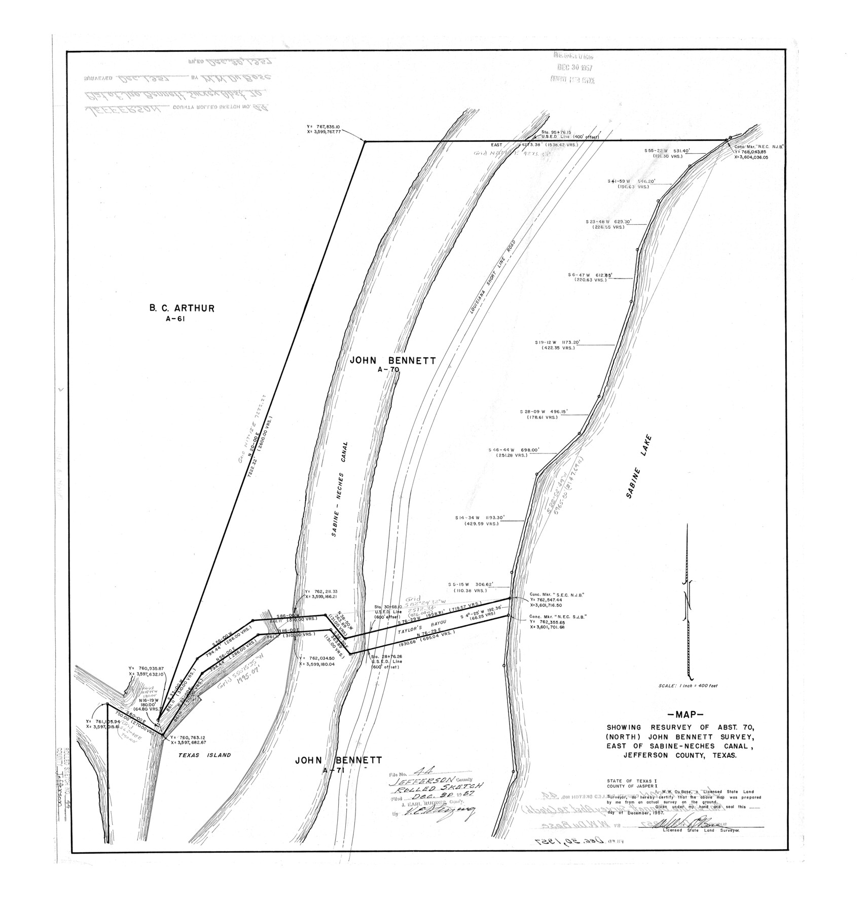
Jefferson County Rolled Sketch 44
Map showing resurvey of abst. 70, (north) John Bennett survey, east of Sabine-Neches Canal, Jefferson County, Texas
-
Map/Doc
6401
-
Collection
General Map Collection
-
Object Dates
1957 (Creation Date)
1957/12/30 (File Date)
-
People and Organizations
W.W. DuBose (Surveyor/Engineer)
-
Counties
Jefferson
-
Subjects
Surveying Rolled Sketch
-
Height x Width
26.9 x 25.5 inches
68.3 x 64.8 cm
-
Scale
1" = 400 feet
-
Comments
See Jefferson County Rolled Sketch 43 (9303) for additional sketch, and Jefferson County Sketch File 41 (28236) for report.
Related maps
Jefferson County Sketch File 41

Print $58.00
- Digital $50.00
Jefferson County Sketch File 41
1957
Size 14.2 x 8.7 inches
Map/Doc 28236
Jefferson County Rolled Sketch 43

Print $40.00
- Digital $50.00
Jefferson County Rolled Sketch 43
1957
Size 50.1 x 18.2 inches
Map/Doc 9303
Part of: General Map Collection
Moore County Sketch File 7

Print $20.00
- Digital $50.00
Moore County Sketch File 7
Size 24.6 x 45.8 inches
Map/Doc 10553
Hall County Sketch File 15

Print $6.00
- Digital $50.00
Hall County Sketch File 15
Size 5.7 x 16.9 inches
Map/Doc 24814
Map of Upshur County

Print $20.00
- Digital $50.00
Map of Upshur County
Size 18.5 x 23.2 inches
Map/Doc 76755
Wilbarger County Rolled Sketch 3

Print $40.00
- Digital $50.00
Wilbarger County Rolled Sketch 3
Size 39.5 x 67.4 inches
Map/Doc 10141
McMullen County Rolled Sketch 19

Print $20.00
- Digital $50.00
McMullen County Rolled Sketch 19
1963
Size 26.6 x 39.6 inches
Map/Doc 6735
Montgomery County Texas Historical Map

Montgomery County Texas Historical Map
Size 23.2 x 35.3 inches
Map/Doc 94404

Map from Corpus Christi to Matagorda Bays, Texas [Inset: Survey of the channel of Copono Bay]
![72976, Map from Corpus Christi to Matagorda Bays, Texas [Inset: Survey of the channel of Copono Bay], General Map Collection](https://historictexasmaps.com/wmedia_w700/maps/72976.tif.jpg)
Print $20.00
- Digital $50.00
Map from Corpus Christi to Matagorda Bays, Texas [Inset: Survey of the channel of Copono Bay]
1846
Size 18.1 x 27.5 inches
Map/Doc 72976
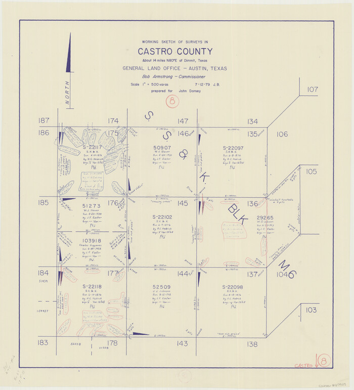
Castro County Working Sketch 8
Print $20.00
- Digital $50.00
Castro County Working Sketch 8
1979
Size 21.2 x 19.3 inches
Map/Doc 67903
United States - Gulf Coast Texas - Northern part of Laguna Madre

Print $20.00
- Digital $50.00
United States - Gulf Coast Texas - Northern part of Laguna Madre
1941
Size 26.9 x 18.3 inches
Map/Doc 72938
Refugio County NRC Article 33.136 Location Key Sheet

Print $20.00
- Digital $50.00
Refugio County NRC Article 33.136 Location Key Sheet
1979
Size 27.3 x 24.0 inches
Map/Doc 88584
Jasper County Sketch File 19

Print $6.00
- Digital $50.00
Jasper County Sketch File 19
1890
Size 14.2 x 8.8 inches
Map/Doc 27815
You may also like
Newton County Working Sketch 43

Print $20.00
- Digital $50.00
Newton County Working Sketch 43
1982
Size 20.7 x 28.6 inches
Map/Doc 71289
Presidio County Sketch File S

Print $27.00
- Digital $50.00
Presidio County Sketch File S
1917
Size 14.3 x 8.8 inches
Map/Doc 34561
Culberson County Rolled Sketch 55

Print $20.00
- Digital $50.00
Culberson County Rolled Sketch 55
1971
Size 22.6 x 17.4 inches
Map/Doc 5676
Flight Mission No. CGI-2N, Frame 179, Cameron County

Print $20.00
- Digital $50.00
Flight Mission No. CGI-2N, Frame 179, Cameron County
1954
Size 18.5 x 22.2 inches
Map/Doc 84539
Map of XIT Lands, vicinity of Farwell, Texas

Print $20.00
- Digital $50.00
Map of XIT Lands, vicinity of Farwell, Texas
Size 19.6 x 30.8 inches
Map/Doc 91654
Concho County Sketch File 8

Print $44.00
- Digital $50.00
Concho County Sketch File 8
1886
Size 16.2 x 12.2 inches
Map/Doc 19131
[Movements & Objectives of the 143rd & 144th Infantry on October 12-13, 1918, Appendix E, No.1]
![94126, [Movements & Objectives of the 143rd & 144th Infantry on October 12-13, 1918, Appendix E, No.1], Non-GLO Digital Images](https://historictexasmaps.com/wmedia_w700/maps/94126-1.tif.jpg)
Print $20.00
[Movements & Objectives of the 143rd & 144th Infantry on October 12-13, 1918, Appendix E, No.1]
1918
Size 22.5 x 20.0 inches
Map/Doc 94126
United States Bathymetric and Fishing Maps including Topographic/Bathymetric Maps

Print $40.00
- Digital $50.00
United States Bathymetric and Fishing Maps including Topographic/Bathymetric Maps
1992
Size 21.3 x 55.1 inches
Map/Doc 76127
[Blocks M-25 and H]
![92978, [Blocks M-25 and H], Twichell Survey Records](https://historictexasmaps.com/wmedia_w700/maps/92978-1.tif.jpg)
Print $20.00
- Digital $50.00
[Blocks M-25 and H]
1922
Size 17.5 x 13.9 inches
Map/Doc 92978
Western Territories of the United States

Print $20.00
- Digital $50.00
Western Territories of the United States
1847
Size 12.1 x 19.0 inches
Map/Doc 93543
Vacancy Application - John H. Tyler near T.C. Ry. Co. Block 1 Surveys 101, 102, 103, & 104. Letters and Maps, Pecos County

Print $279.00
- Digital $50.00
Vacancy Application - John H. Tyler near T.C. Ry. Co. Block 1 Surveys 101, 102, 103, & 104. Letters and Maps, Pecos County
1934
Size 18.1 x 21.1 inches
Map/Doc 2048
Flight Mission No. BRE-1P, Frame 140, Nueces County

Print $20.00
- Digital $50.00
Flight Mission No. BRE-1P, Frame 140, Nueces County
1956
Size 18.8 x 22.7 inches
Map/Doc 86700