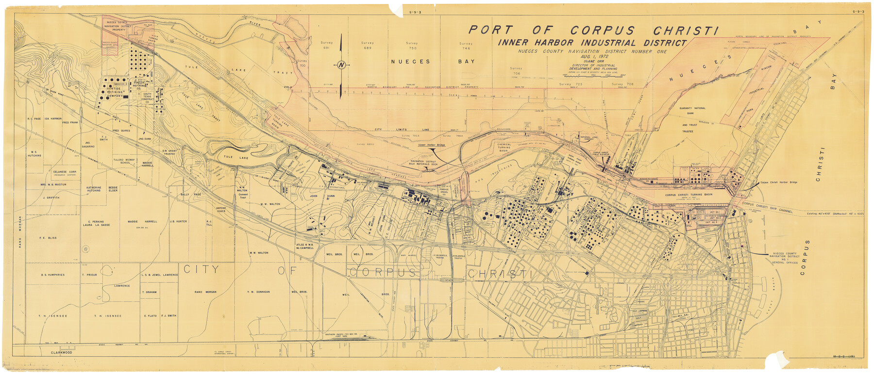
Port of Corpus Christi Inner Harbor Industrial District, Nueces County Navigation District Number One
E-6-5
-
Map/Doc
78635
-
Collection
General Map Collection
-
Object Dates
8/1/1972 (Creation Date)
-
People and Organizations
Nueces County Navigation District No. 1 (Author)
-
Counties
Nueces
-
Subjects
City Nautical Charts
-
Height x Width
43.6 x 101.3 inches
110.7 x 257.3 cm
-
Comments
Port of Corpus Christi Ownership Map of Inner Harbor Industrial District
Part of: General Map Collection
Cherokee County Working Sketch Graphic Index

Print $40.00
- Digital $50.00
Cherokee County Working Sketch Graphic Index
1933
Size 56.7 x 40.0 inches
Map/Doc 76492
Flight Mission No. CRE-2R, Frame 84, Jackson County

Print $20.00
- Digital $50.00
Flight Mission No. CRE-2R, Frame 84, Jackson County
1956
Size 16.1 x 15.9 inches
Map/Doc 85356
Flight Mission No. DAH-9M, Frame 199, Orange County

Print $20.00
- Digital $50.00
Flight Mission No. DAH-9M, Frame 199, Orange County
1953
Size 18.6 x 22.5 inches
Map/Doc 86867
Dimmit County Rolled Sketch 20A

Print $20.00
- Digital $50.00
Dimmit County Rolled Sketch 20A
1999
Size 24.9 x 36.5 inches
Map/Doc 6065
Location Survey of the Southern Kansas Railway, Kiowa Extension from a point in Drake's Location, in Indian Territory 100 miles from south line of Kansas, continuing up Wolf Creek and South Canadian River to Cottonwood Creek in Hutchinson County

Print $20.00
- Digital $50.00
Location Survey of the Southern Kansas Railway, Kiowa Extension from a point in Drake's Location, in Indian Territory 100 miles from south line of Kansas, continuing up Wolf Creek and South Canadian River to Cottonwood Creek in Hutchinson County
1886
Size 38.9 x 36.0 inches
Map/Doc 88838
Panola County Working Sketch 31

Print $20.00
- Digital $50.00
Panola County Working Sketch 31
1981
Map/Doc 71440
Parker County Working Sketch 21

Print $20.00
- Digital $50.00
Parker County Working Sketch 21
2006
Map/Doc 83655
Nueces County Rolled Sketch 112

Print $20.00
- Digital $50.00
Nueces County Rolled Sketch 112
1991
Size 24.5 x 35.9 inches
Map/Doc 7120
Jeff Davis County Working Sketch Graphic Index - west part

Print $20.00
- Digital $50.00
Jeff Davis County Working Sketch Graphic Index - west part
1977
Size 34.0 x 45.3 inches
Map/Doc 76594
Bailey County

Print $20.00
- Digital $50.00
Bailey County
1913
Size 29.0 x 22.5 inches
Map/Doc 66708
Reagan County Working Sketch 39

Print $20.00
- Digital $50.00
Reagan County Working Sketch 39
1971
Size 22.5 x 36.1 inches
Map/Doc 71881
Fractional Township No. 7 South Range No. 3 East of the Indian Meridian, Indian Territory

Print $20.00
- Digital $50.00
Fractional Township No. 7 South Range No. 3 East of the Indian Meridian, Indian Territory
1898
Size 19.2 x 24.3 inches
Map/Doc 75206
You may also like
Cass County Working Sketch 5

Print $20.00
- Digital $50.00
Cass County Working Sketch 5
1936
Size 45.6 x 43.1 inches
Map/Doc 67908
Leon County Working Sketch 21

Print $20.00
- Digital $50.00
Leon County Working Sketch 21
1964
Size 20.9 x 22.9 inches
Map/Doc 70420
Edwards County Sketch File 29

Print $40.00
- Digital $50.00
Edwards County Sketch File 29
Size 19.4 x 15.9 inches
Map/Doc 11432
Floyd County Sketch File 11

Print $2.00
- Digital $50.00
Floyd County Sketch File 11
1914
Size 3.8 x 6.7 inches
Map/Doc 22707
[Surveys along the Nacogdoches River, Richland Creek, and the Trinity River]
![85, [Surveys along the Nacogdoches River, Richland Creek, and the Trinity River], General Map Collection](https://historictexasmaps.com/wmedia_w700/maps/85.tif.jpg)
Print $20.00
- Digital $50.00
[Surveys along the Nacogdoches River, Richland Creek, and the Trinity River]
1840
Size 24.2 x 17.9 inches
Map/Doc 85
[Texas Boundary Line]
![92071, [Texas Boundary Line], Twichell Survey Records](https://historictexasmaps.com/wmedia_w700/maps/92071-1.tif.jpg)
Print $20.00
- Digital $50.00
[Texas Boundary Line]
Size 21.5 x 12.0 inches
Map/Doc 92071
Map of Sherman County

Print $20.00
- Digital $50.00
Map of Sherman County
1902
Size 40.9 x 36.6 inches
Map/Doc 16815
El Paso County Sketch File 35 (4)

Print $38.00
- Digital $50.00
El Paso County Sketch File 35 (4)
1886
Size 14.3 x 9.0 inches
Map/Doc 22199
Blanco County Sketch File 46

Print $4.00
- Digital $50.00
Blanco County Sketch File 46
Size 12.5 x 8.4 inches
Map/Doc 14673
Montgomery County Rolled Sketch 26A

Print $20.00
- Digital $50.00
Montgomery County Rolled Sketch 26A
1941
Size 29.1 x 38.8 inches
Map/Doc 6809
Jackson County

Print $20.00
- Digital $50.00
Jackson County
1840
Size 33.5 x 26.7 inches
Map/Doc 4505
Hardin County Rolled Sketch 10

Print $20.00
- Digital $50.00
Hardin County Rolled Sketch 10
1948
Size 23.7 x 33.0 inches
Map/Doc 6082