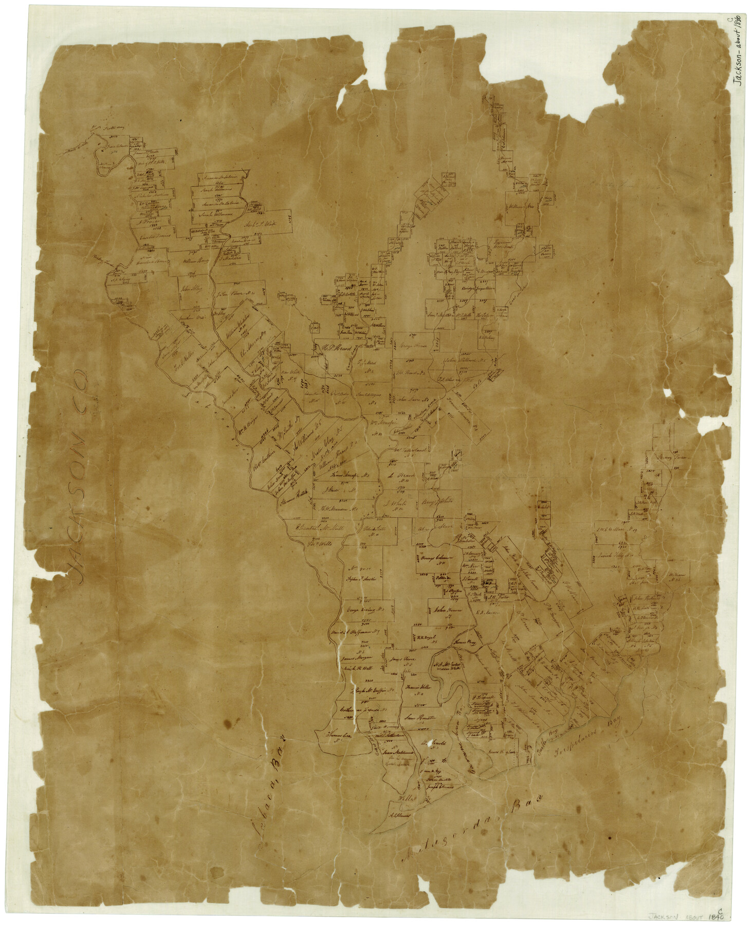
Jackson County
-
Map/Doc
4505
-
Collection
General Map Collection
-
Object Dates
1840 (Creation Date)
-
Counties
Jackson
-
Subjects
County
-
Height x Width
33.5 x 26.7 inches
85.1 x 67.8 cm
-
Features
Carancahua Bay
Texana
Linnville
East Mustang Creek
Panther's Creek
Keller Bay
Matagorda Bay
Trespalacios Bay
Turtle Bay
Smither's Creek
Coxe's [sic] Bay
Labaca [sic] Bay
Mustang Creek
Navidad River
Labaca [sic] River
Sandy Creek
Rocky Ford
Part of: General Map Collection
Presidio County Rolled Sketch 43

Print $20.00
- Digital $50.00
Presidio County Rolled Sketch 43
1907
Size 31.5 x 19.7 inches
Map/Doc 7340
Johnson County Sketch File 10a

Print $4.00
- Digital $50.00
Johnson County Sketch File 10a
1877
Size 6.7 x 10.6 inches
Map/Doc 28445
Upton County Rolled Sketch 56

Print $158.00
- Digital $50.00
Upton County Rolled Sketch 56
1934
Size 10.0 x 15.1 inches
Map/Doc 49413
Terrell County Sketch File 10

Print $44.00
- Digital $50.00
Terrell County Sketch File 10
1902
Size 9.7 x 4.6 inches
Map/Doc 37910
Sutton County Working Sketch 42

Print $20.00
- Digital $50.00
Sutton County Working Sketch 42
1950
Size 34.5 x 29.1 inches
Map/Doc 62385
Culberson County Rolled Sketch 50

Print $20.00
- Digital $50.00
Culberson County Rolled Sketch 50
1963
Size 19.3 x 25.0 inches
Map/Doc 5669
Hockley County Rolled Sketch 6

Print $40.00
- Digital $50.00
Hockley County Rolled Sketch 6
Size 30.6 x 48.2 inches
Map/Doc 6216
Hardin County Sketch File A

Print $20.00
- Digital $50.00
Hardin County Sketch File A
Size 19.3 x 33.4 inches
Map/Doc 11644
Brewster County Working Sketch 108

Print $20.00
- Digital $50.00
Brewster County Working Sketch 108
1981
Size 37.7 x 47.6 inches
Map/Doc 67708
Haskell County

Print $20.00
- Digital $50.00
Haskell County
1933
Size 41.7 x 36.2 inches
Map/Doc 77307
Orange County Working Sketch 42

Print $20.00
- Digital $50.00
Orange County Working Sketch 42
1979
Size 19.6 x 25.4 inches
Map/Doc 71374
Texas since 1850

Print $20.00
- Digital $50.00
Texas since 1850
1897
Size 13.3 x 15.5 inches
Map/Doc 93413
You may also like
Dimmit County Working Sketch 29

Print $40.00
- Digital $50.00
Dimmit County Working Sketch 29
1957
Size 58.1 x 36.2 inches
Map/Doc 68690
[Archer County School Land]
![90324, [Archer County School Land], Twichell Survey Records](https://historictexasmaps.com/wmedia_w700/maps/90324-1.tif.jpg)
Print $20.00
- Digital $50.00
[Archer County School Land]
Size 21.7 x 16.7 inches
Map/Doc 90324
[San Antonio & Aransas Pass]
![64208, [San Antonio & Aransas Pass], General Map Collection](https://historictexasmaps.com/wmedia_w700/maps/64208.tif.jpg)
Print $40.00
- Digital $50.00
[San Antonio & Aransas Pass]
Size 17.0 x 50.7 inches
Map/Doc 64208
Wilson County Sketch File 12

Print $8.00
- Digital $50.00
Wilson County Sketch File 12
1841
Size 14.1 x 8.6 inches
Map/Doc 40425
Liberty County Sketch File 56

Print $20.00
- Digital $50.00
Liberty County Sketch File 56
Size 11.9 x 18.7 inches
Map/Doc 11996
Knox County Sketch File 9

Print $4.00
- Digital $50.00
Knox County Sketch File 9
1889
Size 11.1 x 8.8 inches
Map/Doc 29221
Coke County Sketch File 24

Print $6.00
- Digital $50.00
Coke County Sketch File 24
1927
Size 11.1 x 8.8 inches
Map/Doc 18615
Coast Chart No. 212 - From Latitude 26° 33' to the Rio Grande Texas

Print $20.00
- Digital $50.00
Coast Chart No. 212 - From Latitude 26° 33' to the Rio Grande Texas
1886
Size 18.3 x 27.4 inches
Map/Doc 72825
Erath County Working Sketch 39

Print $20.00
- Digital $50.00
Erath County Working Sketch 39
1976
Size 26.9 x 28.0 inches
Map/Doc 69120
[Sketch for Mineral Applications 26885-6 - Reagan and Crockett Cos., W. H. Bland]
![3219, [Sketch for Mineral Applications 26885-6 - Reagan and Crockett Cos., W. H. Bland], General Map Collection](https://historictexasmaps.com/wmedia_w700/maps/3219-1.tif.jpg)
Print $20.00
- Digital $50.00
[Sketch for Mineral Applications 26885-6 - Reagan and Crockett Cos., W. H. Bland]
1932
Size 38.4 x 9.7 inches
Map/Doc 3219
Flight Mission No. DCL-5C, Frame 75, Kenedy County

Print $20.00
- Digital $50.00
Flight Mission No. DCL-5C, Frame 75, Kenedy County
1943
Size 18.6 x 22.2 inches
Map/Doc 85858
The University of Texas at Austin

The University of Texas at Austin
Size 16.1 x 17.1 inches
Map/Doc 94387