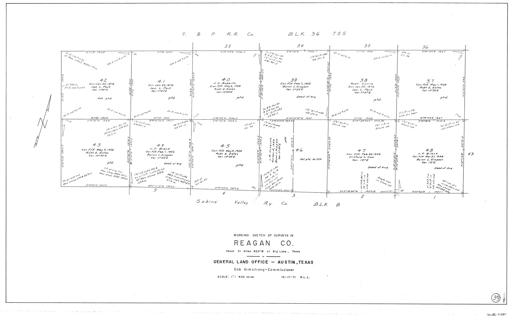
Reagan County Working Sketch 39
- 
                          Map/Doc
71881
 - 
                            Collection
General Map Collection
 - 
                            Object Dates
10/17/1971 (Creation Date)
 - 
                            People and Organizations
M. L. Liles (Draftsman)
 - 
                            Counties
Reagan
 - 
                            Subjects
Surveying Working Sketch
 - 
                            Height x Width
22.5 x 36.1 inches
57.2 x 91.7 cm
 - 
                            Scale
1" = 400 varas
 
Part of: General Map Collection
            Erath County Working Sketch 22


                                            Print $20.00                    
                                             -                         Digital $50.00                                    
                Erath County Working Sketch 22
1965
Size 29.8 x 36.8 inches
                                Map/Doc 69103
            
            Webb County Sketch File 6-1


                                            Print $6.00                    
                                             -                         Digital $50.00                                    
                Webb County Sketch File 6-1
1877
Size 9.8 x 12.7 inches
                                Map/Doc 39737
            
            Menard County Working Sketch 1


                                            Print $20.00                    
                                             -                         Digital $50.00                                    
                Menard County Working Sketch 1
1905
Size 23.3 x 18.9 inches
                                Map/Doc 70948
            
            Val Verde County Sketch File 8


                                            Print $38.00                    
                                             -                         Digital $50.00                                    
                Val Verde County Sketch File 8
1885
Size 22.6 x 23.2 inches
                                Map/Doc 12564
            
            Plot of land tracts situated in Austin Co. west of Mill Creek opposite and above the fork of the same


                                            Print $2.00                    
                                             -                         Digital $50.00                                    
                Plot of land tracts situated in Austin Co. west of Mill Creek opposite and above the fork of the same
1845
Size 7.7 x 8.1 inches
                                Map/Doc 224
            
            Trinity County Sketch File 43


                                            Print $40.00                    
                                             -                         Digital $50.00                                    
                Trinity County Sketch File 43
1854
Size 19.2 x 23.6 inches
                                Map/Doc 12495
            
            Texas Hill Country Trail Region


            Texas Hill Country Trail Region
Size 18.1 x 24.2 inches
                                Map/Doc 96872
            
            Duval County Sketch File 32a


                                            Print $20.00                    
                                             -                         Digital $50.00                                    
                Duval County Sketch File 32a
1932
Size 16.2 x 14.2 inches
                                Map/Doc 11390
            
            [Surveys in Vehlein's Colony along the San Jacinto River]


                                            Print $20.00                    
                                             -                         Digital $50.00                                    
                [Surveys in Vehlein's Colony along the San Jacinto River]
1837
Size 19.4 x 15.7 inches
                                Map/Doc 27
            
            Stonewall County Working Sketch 6


                                            Print $20.00                    
                                             -                         Digital $50.00                                    
                Stonewall County Working Sketch 6
1949
Size 16.5 x 30.1 inches
                                Map/Doc 62313
            
            Leon County Sketch File 2


                                            Print $4.00                    
                                             -                         Digital $50.00                                    
                Leon County Sketch File 2
1852
Size 8.1 x 5.1 inches
                                Map/Doc 29711
            
            Nueces County Rolled Sketch 115


                                            Print $215.00                    
                                    
                Nueces County Rolled Sketch 115
1992
Size 24.2 x 35.2 inches
                                Map/Doc 7126
            You may also like
            Anderson County


                                            Print $20.00                    
                                             -                         Digital $50.00                                    
                Anderson County
1861
Size 18.0 x 21.2 inches
                                Map/Doc 774
            
            [J. Poitevent Block 2, T. T. RR. Block 2, C. C. Slaughter Block 1]


                                            Print $2.00                    
                                             -                         Digital $50.00                                    
                [J. Poitevent Block 2, T. T. RR. Block 2, C. C. Slaughter Block 1]
Size 9.1 x 11.7 inches
                                Map/Doc 90619
            
            Flight Mission No. DAH-17M, Frame 68, Orange County


                                            Print $20.00                    
                                             -                         Digital $50.00                                    
                Flight Mission No. DAH-17M, Frame 68, Orange County
1953
Size 18.6 x 22.4 inches
                                Map/Doc 86902
            
            Revised Map of MacDade, Bastrop County, Texas


                                            Print $20.00                    
                                             -                         Digital $50.00                                    
                Revised Map of MacDade, Bastrop County, Texas
Size 26.6 x 18.4 inches
                                Map/Doc 78478
            
            Taylor County Working Sketch 19


                                            Print $20.00                    
                                             -                         Digital $50.00                                    
                Taylor County Working Sketch 19
1985
Size 30.0 x 44.0 inches
                                Map/Doc 69629
            
            Sam Street's Map of Dallas County, Texas


            Sam Street's Map of Dallas County, Texas
1900
Size 32.1 x 28.5 inches
                                Map/Doc 76173
            
            Webb County Rolled Sketch 63


                                            Print $20.00                    
                                             -                         Digital $50.00                                    
                Webb County Rolled Sketch 63
1948
Size 39.4 x 37.0 inches
                                Map/Doc 10129
            
            Shelby County


                                            Print $20.00                    
                                             -                         Digital $50.00                                    
                Shelby County
1945
Size 41.6 x 45.9 inches
                                Map/Doc 73288
            
            Flight Mission No. DAH-9M, Frame 88, Orange County


                                            Print $20.00                    
                                             -                         Digital $50.00                                    
                Flight Mission No. DAH-9M, Frame 88, Orange County
1953
Size 18.5 x 22.6 inches
                                Map/Doc 86852
            
            Hartley County Boundary File 5


                                            Print $6.00                    
                                             -                         Digital $50.00                                    
                Hartley County Boundary File 5
Size 12.7 x 8.2 inches
                                Map/Doc 54515
            
            [L. C. Dennison and other surveys to the east, south of the south line of T. & P. Blocks 4 and 6]


                                            Print $20.00                    
                                             -                         Digital $50.00                                    
                [L. C. Dennison and other surveys to the east, south of the south line of T. & P. Blocks 4 and 6]
1919
Size 32.1 x 17.6 inches
                                Map/Doc 93050