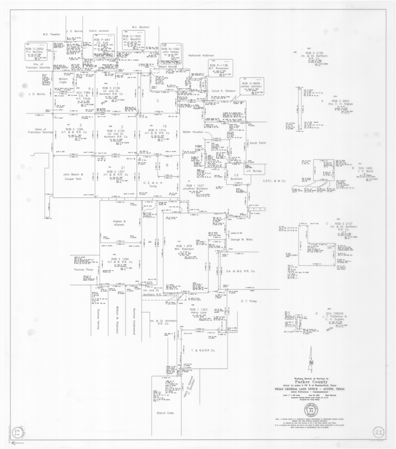
Parker County Working Sketch 21
-
Map/Doc
83655
-
Collection
General Map Collection
-
Object Dates
6/28/2006 (Creation Date)
-
People and Organizations
Jerry E. Patterson (GLO Commissioner)
Ryan Hancock (Draftsman)
-
Counties
Parker
-
Subjects
Surveying Working Sketch
-
Scale
1" = 600 varas
Part of: General Map Collection
Millennium in Maps - Exploration

Millennium in Maps - Exploration
Size 20.6 x 31.5 inches
Map/Doc 95931
Red River County Working Sketch 74

Print $20.00
- Digital $50.00
Red River County Working Sketch 74
1980
Size 24.2 x 22.8 inches
Map/Doc 72057
Mississippi River to Galveston

Print $40.00
- Digital $50.00
Mississippi River to Galveston
1986
Size 36.8 x 49.9 inches
Map/Doc 69948
Flight Mission No. CRK-7P, Frame 81, Refugio County

Print $20.00
- Digital $50.00
Flight Mission No. CRK-7P, Frame 81, Refugio County
1956
Size 18.4 x 22.1 inches
Map/Doc 86952
Right of Way and Track Map, the Missouri, Kansas and Texas Ry. of Texas - Henrietta Division

Print $20.00
- Digital $50.00
Right of Way and Track Map, the Missouri, Kansas and Texas Ry. of Texas - Henrietta Division
1918
Size 11.8 x 26.9 inches
Map/Doc 64748
Collin County Working Sketch 1

Print $20.00
- Digital $50.00
Collin County Working Sketch 1
1921
Size 26.6 x 23.4 inches
Map/Doc 68095
Eastland County Working Sketch 55

Print $20.00
- Digital $50.00
Eastland County Working Sketch 55
1984
Size 33.5 x 37.8 inches
Map/Doc 68836
Tom Green County Sketch File 53

Print $8.00
- Digital $50.00
Tom Green County Sketch File 53
1884
Size 14.2 x 9.1 inches
Map/Doc 38221
United States - Gulf Coast - From Latitude 26° 33' to the Rio Grande Texas

Print $20.00
- Digital $50.00
United States - Gulf Coast - From Latitude 26° 33' to the Rio Grande Texas
1918
Size 27.6 x 18.1 inches
Map/Doc 72849

Flight Mission No. CLL-1N, Frame 194, Willacy County

Print $20.00
- Digital $50.00
Flight Mission No. CLL-1N, Frame 194, Willacy County
1954
Size 18.5 x 22.1 inches
Map/Doc 87064
Jefferson County Rolled Sketch 49

Print $40.00
- Digital $50.00
Jefferson County Rolled Sketch 49
1963
Size 30.6 x 57.5 inches
Map/Doc 46415
You may also like
Garza County Sketch File D

Print $20.00
- Digital $50.00
Garza County Sketch File D
1901
Size 18.4 x 12.2 inches
Map/Doc 11550
Map of the Recognised Line M. El. P. & P. R.R. from Texas & Arkansas State Line to Milam & Bexar Land District Line

Print $40.00
- Digital $50.00
Map of the Recognised Line M. El. P. & P. R.R. from Texas & Arkansas State Line to Milam & Bexar Land District Line
1856
Size 14.3 x 89.8 inches
Map/Doc 64053
University of Texas System University Lands

Print $20.00
- Digital $50.00
University of Texas System University Lands
Size 17.9 x 23.3 inches
Map/Doc 93244
Sketch from the map of Bailey Co.

Print $2.00
- Digital $50.00
Sketch from the map of Bailey Co.
Size 8.4 x 7.6 inches
Map/Doc 464
Crockett County Sketch File 67

Print $20.00
- Digital $50.00
Crockett County Sketch File 67
1927
Size 30.1 x 26.6 inches
Map/Doc 11231
Crosby County Sketch File 32

Print $20.00
- Digital $50.00
Crosby County Sketch File 32
1938
Size 23.2 x 31.8 inches
Map/Doc 11258
Moore County Rolled Sketch 16A

Print $20.00
- Digital $50.00
Moore County Rolled Sketch 16A
1982
Size 21.1 x 33.4 inches
Map/Doc 6834
[Miller Day Ranch]
![81517, [Miller Day Ranch], General Map Collection](https://historictexasmaps.com/wmedia_w700/maps/81517.tif.jpg)
Print $40.00
- Digital $50.00
[Miller Day Ranch]
1995
Size 60.6 x 38.0 inches
Map/Doc 81517
Starr County Rolled Sketch 23

Print $20.00
- Digital $50.00
Starr County Rolled Sketch 23
1938
Size 36.8 x 24.9 inches
Map/Doc 7807
[Surveys along the Red River made for titles under Radford Berry, Commissioner]
![32, [Surveys along the Red River made for titles under Radford Berry, Commissioner], General Map Collection](https://historictexasmaps.com/wmedia_w700/maps/32.tif.jpg)
Print $20.00
- Digital $50.00
[Surveys along the Red River made for titles under Radford Berry, Commissioner]
Size 23.3 x 19.5 inches
Map/Doc 32
Calhoun County Rolled Sketch 31

Print $20.00
- Digital $50.00
Calhoun County Rolled Sketch 31
Size 44.5 x 30.0 inches
Map/Doc 5377
Henderson County Boundary File 43

Print $28.00
- Digital $50.00
Henderson County Boundary File 43
Size 5.0 x 8.3 inches
Map/Doc 54708