Blanco County Sketch File 46
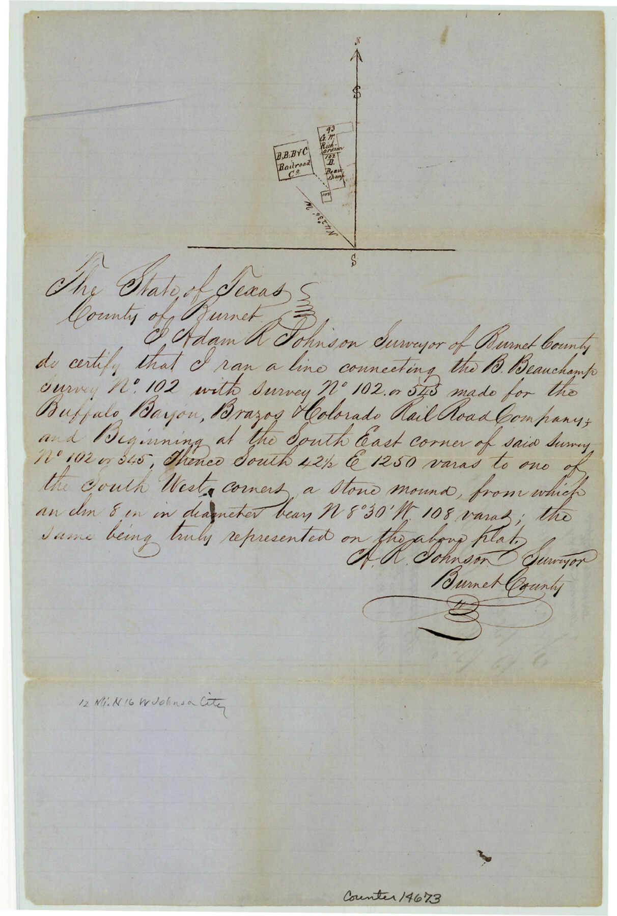
[Sketch of B. Beauchamp and B. B. B. & C. R.R. Co. surveys]
-
Map/Doc
14673
-
Collection
General Map Collection
-
Object Dates
1857/3/31 (File Date)
-
People and Organizations
Adam R. Johnson (Surveyor/Engineer)
-
Counties
Blanco
-
Subjects
Surveying Sketch File
-
Height x Width
12.5 x 8.4 inches
31.8 x 21.3 cm
-
Medium
paper, manuscript
Part of: General Map Collection
Fisher County Sketch File 12

Print $22.00
- Digital $50.00
Fisher County Sketch File 12
1893
Size 9.0 x 7.0 inches
Map/Doc 22577
Crockett County Sketch File 81

Print $4.00
- Digital $50.00
Crockett County Sketch File 81
1939
Size 11.3 x 8.5 inches
Map/Doc 19893
Armstrong County Sketch File 9

Print $12.00
- Digital $50.00
Armstrong County Sketch File 9
1904
Size 11.6 x 9.1 inches
Map/Doc 41460
Crockett County Sketch File 58

Print $20.00
- Digital $50.00
Crockett County Sketch File 58
1932
Size 17.9 x 23.2 inches
Map/Doc 11226
Texas Coordinate File 3

Print $40.00
- Digital $50.00
Texas Coordinate File 3
Size 36.1 x 49.1 inches
Map/Doc 75306
Fractional Township No. 8 South Range No. 7 East of the Indian Meridian, Indian Territory

Print $20.00
- Digital $50.00
Fractional Township No. 8 South Range No. 7 East of the Indian Meridian, Indian Territory
1898
Size 19.2 x 24.3 inches
Map/Doc 75213
Dickens County

Print $20.00
- Digital $50.00
Dickens County
1915
Size 42.4 x 39.3 inches
Map/Doc 4722
Starr County Sketch File 26

Print $20.00
- Digital $50.00
Starr County Sketch File 26
1923
Size 31.7 x 27.2 inches
Map/Doc 10607
Upton County Sketch File 20

Print $40.00
- Digital $50.00
Upton County Sketch File 20
1927
Size 18.5 x 29.2 inches
Map/Doc 12516
Archer County Sketch File 25

Print $40.00
- Digital $50.00
Archer County Sketch File 25
Size 22.3 x 46.6 inches
Map/Doc 10348
Nacogdoches County Boundary File 1

Print $36.00
- Digital $50.00
Nacogdoches County Boundary File 1
Size 6.7 x 4.4 inches
Map/Doc 57562
Cooke County Sketch File 42

Print $8.00
- Digital $50.00
Cooke County Sketch File 42
1940
Size 14.3 x 8.8 inches
Map/Doc 19316
You may also like
Atascosa County Sketch File 13

Print $4.00
- Digital $50.00
Atascosa County Sketch File 13
1867
Size 12.8 x 8.2 inches
Map/Doc 13771
Flight Mission No. DIX-6P, Frame 200, Aransas County

Print $20.00
- Digital $50.00
Flight Mission No. DIX-6P, Frame 200, Aransas County
1956
Size 19.0 x 22.7 inches
Map/Doc 83862

Lampasas County Sketch File 19

Print $4.00
- Digital $50.00
Lampasas County Sketch File 19
1888
Size 10.3 x 8.2 inches
Map/Doc 29432
Schleicher County Working Sketch 4

Print $20.00
- Digital $50.00
Schleicher County Working Sketch 4
1916
Size 21.0 x 32.6 inches
Map/Doc 63806
Dawson County

Print $20.00
- Digital $50.00
Dawson County
1900
Size 40.5 x 36.3 inches
Map/Doc 66798
Brewster County Working Sketch 26

Print $20.00
- Digital $50.00
Brewster County Working Sketch 26
1940
Size 20.7 x 32.1 inches
Map/Doc 67560
Motley County Sketch File B4 (N)

Print $20.00
- Digital $50.00
Motley County Sketch File B4 (N)
1900
Size 23.5 x 25.8 inches
Map/Doc 42151
Palo Pinto County Sketch File A

Print $6.00
- Digital $50.00
Palo Pinto County Sketch File A
Size 8.7 x 4.1 inches
Map/Doc 33389
Aransas County Rolled Sketch 11

Print $20.00
- Digital $50.00
Aransas County Rolled Sketch 11
Size 42.0 x 36.4 inches
Map/Doc 8410
Hardin County Sketch File 52

Print $6.00
- Digital $50.00
Hardin County Sketch File 52
Size 11.5 x 8.9 inches
Map/Doc 25210
Panola County Working Sketch 31

Print $20.00
- Digital $50.00
Panola County Working Sketch 31
1981
Map/Doc 71440