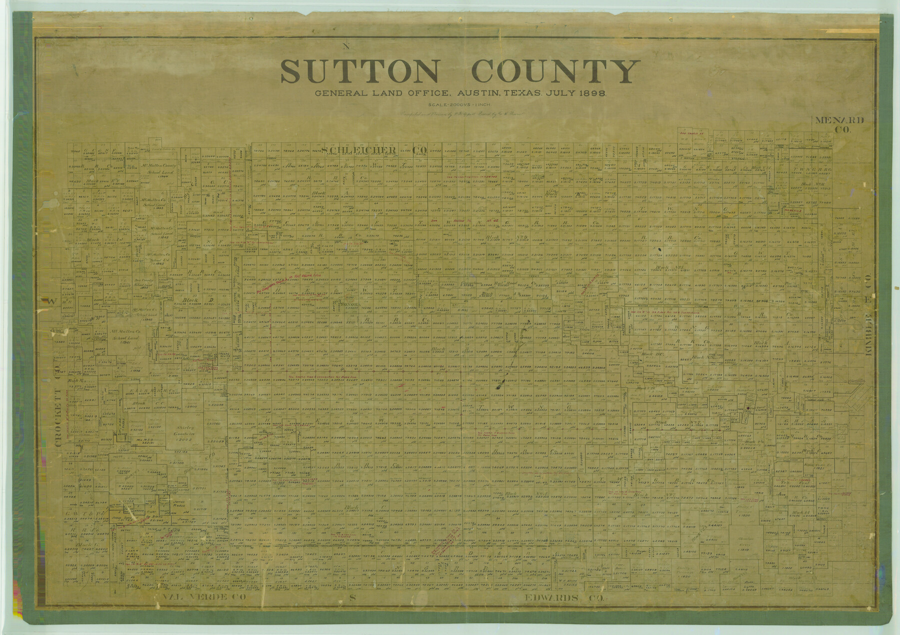
Sutton County
-
Map/Doc
78392
-
Collection
General Map Collection
-
Object Dates
1898 (Creation Date)
-
People and Organizations
Texas General Land Office (Publisher)
P.F. Appell (Draftsman)
P.F. Appell (Compiler)
-
Counties
Sutton
-
Subjects
County
-
Height x Width
41.1 x 58.3 inches
104.4 x 148.1 cm
-
Comments
Note on back: "Retired June 17, 1941".
Traced by G. W. Davis. -
Features
Pecan Spring
Pecan Creek
Sonora
Copperas Creek
North Fork of Llano River
Fort Terret
Kaechters Lake
Elbow Lake
Menard Creek
Seller's Draw
Devil's River
East Fork of Devil's River
West Copperas Creek
Part of: General Map Collection
Lampasas County Sketch File 15

Print $20.00
- Digital $50.00
Lampasas County Sketch File 15
1888
Size 24.5 x 27.1 inches
Map/Doc 11975
Milam County Boundary File 5a

Print $12.00
- Digital $50.00
Milam County Boundary File 5a
Size 14.1 x 8.5 inches
Map/Doc 57233

Andrews County Sketch File 7

Print $6.00
- Digital $50.00
Andrews County Sketch File 7
1942
Size 11.2 x 8.8 inches
Map/Doc 12828
Mitchell County Rolled Sketch 3

Print $40.00
- Digital $50.00
Mitchell County Rolled Sketch 3
1940
Size 39.6 x 49.0 inches
Map/Doc 9524
Gregg County Sketch File 6

Print $10.00
- Digital $50.00
Gregg County Sketch File 6
1931
Size 11.2 x 8.8 inches
Map/Doc 24577
Map of the Town of Giddings

Print $20.00
- Digital $50.00
Map of the Town of Giddings
1871
Size 23.9 x 29.8 inches
Map/Doc 89270
Kerr County Sketch File 12

Print $4.00
- Digital $50.00
Kerr County Sketch File 12
1901
Size 6.7 x 11.1 inches
Map/Doc 28881
Hamilton County Sketch File 3

Print $4.00
- Digital $50.00
Hamilton County Sketch File 3
1852
Size 12.7 x 8.0 inches
Map/Doc 24901
Flight Mission No. CUG-2P, Frame 68, Kleberg County

Print $20.00
- Digital $50.00
Flight Mission No. CUG-2P, Frame 68, Kleberg County
1956
Size 18.5 x 22.3 inches
Map/Doc 86205
Ector County Working Sketch 31

Print $40.00
- Digital $50.00
Ector County Working Sketch 31
1980
Size 36.0 x 51.0 inches
Map/Doc 68874
Red River County Working Sketch 83

Print $20.00
- Digital $50.00
Red River County Working Sketch 83
1996
Size 21.0 x 22.3 inches
Map/Doc 72069
You may also like
Haskell County

Print $20.00
- Digital $50.00
Haskell County
1933
Size 41.7 x 36.2 inches
Map/Doc 77307
Flight Mission No. DQN-5K, Frame 149, Calhoun County

Print $20.00
- Digital $50.00
Flight Mission No. DQN-5K, Frame 149, Calhoun County
1953
Size 18.5 x 22.2 inches
Map/Doc 84424
Burleson County Working Sketch 15

Print $20.00
- Digital $50.00
Burleson County Working Sketch 15
1980
Size 15.0 x 21.1 inches
Map/Doc 67734
San Patricio County Sketch File 36

Print $26.00
- Digital $50.00
San Patricio County Sketch File 36
1940
Size 11.3 x 8.7 inches
Map/Doc 36129
Flight Mission No. DIX-10P, Frame 76, Aransas County

Print $20.00
- Digital $50.00
Flight Mission No. DIX-10P, Frame 76, Aransas County
1956
Size 18.8 x 22.4 inches
Map/Doc 83937
Galveston County NRC Article 33.136 Sketch 53

Print $24.00
- Digital $50.00
Galveston County NRC Article 33.136 Sketch 53
2009
Size 22.3 x 34.0 inches
Map/Doc 94609
Flight Mission No. DIX-5P, Frame 141, Aransas County

Print $20.00
- Digital $50.00
Flight Mission No. DIX-5P, Frame 141, Aransas County
1956
Size 17.8 x 18.4 inches
Map/Doc 83802
Flight Mission No. CRC-6R, Frame 13, Chambers County

Print $20.00
- Digital $50.00
Flight Mission No. CRC-6R, Frame 13, Chambers County
1956
Size 18.6 x 22.3 inches
Map/Doc 84967

Polk County Sketch File 29 1/2

Print $4.00
- Digital $50.00
Polk County Sketch File 29 1/2
Size 8.7 x 12.5 inches
Map/Doc 34204
Mason County Boundary File 5a

Print $40.00
- Digital $50.00
Mason County Boundary File 5a
Size 18.0 x 32.6 inches
Map/Doc 56872
Kimble County Sketch File 32

Print $20.00
- Digital $50.00
Kimble County Sketch File 32
1957
Size 18.4 x 21.6 inches
Map/Doc 11930