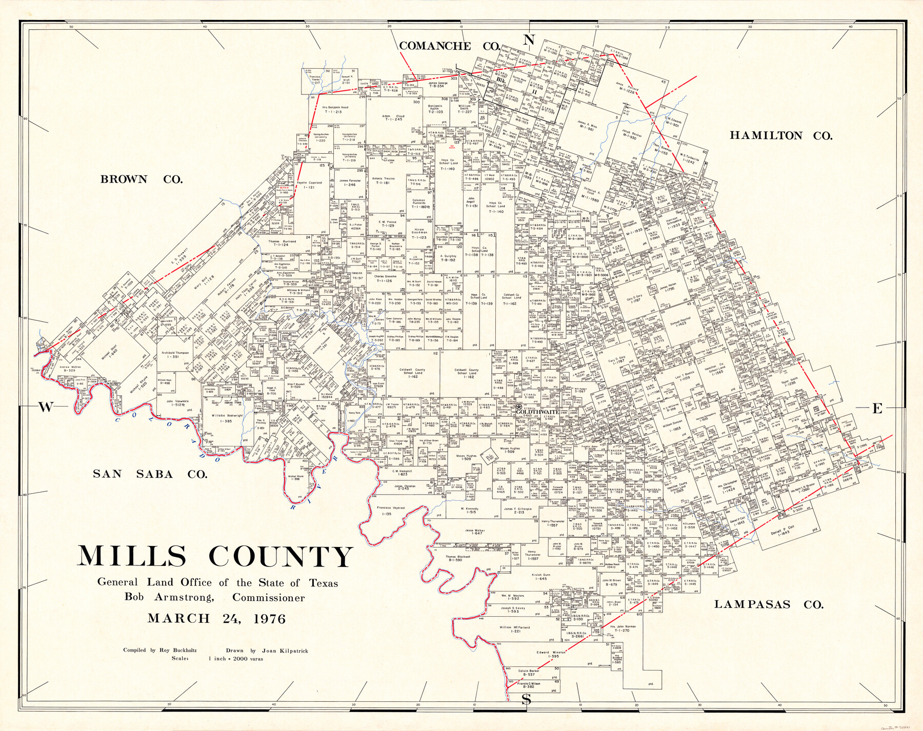
Mills County
-
Map/Doc
73241
-
Collection
General Map Collection
-
Object Dates
3/24/1976 (Creation Date)
-
People and Organizations
Bob Armstrong (GLO Commissioner)
Joan Kilpatrick (Draftsman)
Roy Buckholts (Compiler)
-
Counties
Mills
-
Subjects
County
-
Height x Width
37.7 x 47.3 inches
95.8 x 120.1 cm
-
Scale
1" = 2000 varas
-
Comments
Leroy lettered.
-
Features
Colorado River
Goldthwaite
Part of: General Map Collection
Erath County Working Sketch 15

Print $20.00
- Digital $50.00
Erath County Working Sketch 15
1961
Size 19.8 x 15.4 inches
Map/Doc 69096
Glasscock County Rolled Sketch 1

Print $20.00
- Digital $50.00
Glasscock County Rolled Sketch 1
1906
Size 37.3 x 33.6 inches
Map/Doc 9055
Jeff Davis County Working Sketch 17

Print $3.00
- Digital $50.00
Jeff Davis County Working Sketch 17
1955
Size 10.9 x 9.0 inches
Map/Doc 66512
Leon County Working Sketch 1

Print $20.00
- Digital $50.00
Leon County Working Sketch 1
Size 16.1 x 18.7 inches
Map/Doc 70400
Stonewall County

Print $20.00
- Digital $50.00
Stonewall County
1879
Size 22.7 x 19.1 inches
Map/Doc 4058
Flight Mission No. CRC-3R, Frame 104, Chambers County

Print $20.00
- Digital $50.00
Flight Mission No. CRC-3R, Frame 104, Chambers County
1956
Size 18.6 x 22.3 inches
Map/Doc 84842
Bandera County Working Sketch 5

Print $3.00
- Digital $50.00
Bandera County Working Sketch 5
1915
Size 12.0 x 9.0 inches
Map/Doc 67598
Mason County Sketch File 21A

Print $20.00
- Digital $50.00
Mason County Sketch File 21A
1932
Size 19.2 x 26.6 inches
Map/Doc 12037
Andrews County Boundary File 2c

Print $70.00
- Digital $50.00
Andrews County Boundary File 2c
Size 14.6 x 9.2 inches
Map/Doc 49709
Geographically Correct County Map showing the lines of the Cotton Belt Route (St. Louis Southwestern Railway Co., St. Louis Southwestern Railway Co. of Texas, Tyler Southeastern Railway Co.) and Connections

Print $20.00
- Digital $50.00
Geographically Correct County Map showing the lines of the Cotton Belt Route (St. Louis Southwestern Railway Co., St. Louis Southwestern Railway Co. of Texas, Tyler Southeastern Railway Co.) and Connections
1900
Size 35.2 x 30.4 inches
Map/Doc 95147
Orange County Sketch File 17

Print $50.00
- Digital $50.00
Orange County Sketch File 17
1922
Size 11.1 x 8.6 inches
Map/Doc 33337
Flight Mission No. BQR-3K, Frame 163, Brazoria County

Print $20.00
- Digital $50.00
Flight Mission No. BQR-3K, Frame 163, Brazoria County
1952
Size 18.7 x 22.3 inches
Map/Doc 83990
You may also like
Padre Island National Seashore, Texas - Dependent Resurvey

Print $4.00
- Digital $50.00
Padre Island National Seashore, Texas - Dependent Resurvey
2001
Size 17.9 x 24.0 inches
Map/Doc 60550
Rockwall County Sketch File 3

Print $6.00
Rockwall County Sketch File 3
1851
Size 17.2 x 11.6 inches
Map/Doc 35417
Map of the United States Engraved to Illustrate Mitchell's School and Family Geography

Print $20.00
Map of the United States Engraved to Illustrate Mitchell's School and Family Geography
1839
Size 11.6 x 17.4 inches
Map/Doc 79734
Navarro County Boundary File 1a

Print $42.00
- Digital $50.00
Navarro County Boundary File 1a
Size 9.5 x 6.1 inches
Map/Doc 57605
Hidalgo County Working Sketch 8

Print $40.00
- Digital $50.00
Hidalgo County Working Sketch 8
1963
Size 25.7 x 72.8 inches
Map/Doc 66185
Orange County NRC Article 33.136 Sketch 6

Print $42.00
Orange County NRC Article 33.136 Sketch 6
2025
Map/Doc 97430

Flight Mission No. DIX-10P, Frame 69, Aransas County

Print $20.00
- Digital $50.00
Flight Mission No. DIX-10P, Frame 69, Aransas County
1956
Size 18.8 x 22.4 inches
Map/Doc 83930
Map of Hays County, Texas

Print $20.00
- Digital $50.00
Map of Hays County, Texas
1880
Size 28.9 x 23.6 inches
Map/Doc 401
Houston, (Capital de Tejas)

Print $20.00
- Digital $50.00
Houston, (Capital de Tejas)
1845
Size 6.8 x 10.0 inches
Map/Doc 97238

[Map of Sabine County]
![4009, [Map of Sabine County], General Map Collection](https://historictexasmaps.com/wmedia_w700/maps/4009.tif.jpg)
Print $20.00
- Digital $50.00
[Map of Sabine County]
1839
Size 23.9 x 18.9 inches
Map/Doc 4009