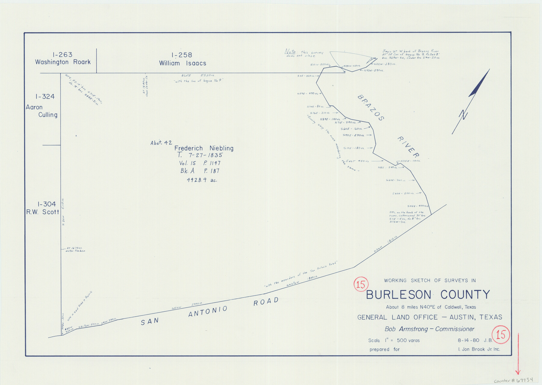
Burleson County Working Sketch 15
-
Map/Doc
67734
-
Collection
General Map Collection
-
Object Dates
8/14/1980 (Creation Date)
-
Counties
Burleson
-
Subjects
Surveying Working Sketch
-
Height x Width
15.0 x 21.1 inches
38.1 x 53.6 cm
-
Scale
1" = 500 varas
Part of: General Map Collection
Presidio County Sketch File 122

Print $22.00
- Digital $50.00
Presidio County Sketch File 122
2010
Size 11.0 x 8.5 inches
Map/Doc 89604
Flight Mission No. BRA-16M, Frame 175, Jefferson County

Print $20.00
- Digital $50.00
Flight Mission No. BRA-16M, Frame 175, Jefferson County
1953
Size 18.6 x 22.4 inches
Map/Doc 85773
Refugio County Sketch File 16

Print $4.00
- Digital $50.00
Refugio County Sketch File 16
Size 7.1 x 8.2 inches
Map/Doc 35270
Burnet County Sketch File 27a

Print $10.00
- Digital $50.00
Burnet County Sketch File 27a
1876
Size 8.7 x 8.2 inches
Map/Doc 16732
[Surveys along Eight Mile Creek, Harrison District]
![278, [Surveys along Eight Mile Creek, Harrison District], General Map Collection](https://historictexasmaps.com/wmedia_w700/maps/278.tif.jpg)
Print $3.00
- Digital $50.00
[Surveys along Eight Mile Creek, Harrison District]
Size 12.6 x 9.3 inches
Map/Doc 278
Jefferson County Sketch File 39

Print $20.00
- Digital $50.00
Jefferson County Sketch File 39
Size 14.3 x 8.7 inches
Map/Doc 28218
Val Verde County Rolled Sketch 55

Print $20.00
- Digital $50.00
Val Verde County Rolled Sketch 55
1940
Size 32.0 x 23.3 inches
Map/Doc 8124
Jim Hogg County Working Sketch 10

Print $20.00
- Digital $50.00
Jim Hogg County Working Sketch 10
Size 18.8 x 15.6 inches
Map/Doc 66596
Jefferson County Rolled Sketch 5

Print $20.00
- Digital $50.00
Jefferson County Rolled Sketch 5
1913
Size 47.0 x 40.7 inches
Map/Doc 9270
Grimes County Sketch File 4a

Print $6.00
- Digital $50.00
Grimes County Sketch File 4a
1873
Size 13.0 x 8.4 inches
Map/Doc 24656
Webb County Rolled Sketch 67

Print $20.00
- Digital $50.00
Webb County Rolled Sketch 67
1927
Size 31.4 x 32.0 inches
Map/Doc 10130
Duval County Working Sketch 51

Print $20.00
- Digital $50.00
Duval County Working Sketch 51
1986
Size 27.3 x 35.3 inches
Map/Doc 68775
You may also like
Bowie County Sketch File 10

Print $8.00
- Digital $50.00
Bowie County Sketch File 10
1992
Size 11.1 x 8.8 inches
Map/Doc 14912
[Sketch for Mineral Application 13271- Trinity River]
![65628, [Sketch for Mineral Application 13271- Trinity River], General Map Collection](https://historictexasmaps.com/wmedia_w700/maps/65628.tif.jpg)
Print $40.00
- Digital $50.00
[Sketch for Mineral Application 13271- Trinity River]
1925
Size 63.1 x 22.4 inches
Map/Doc 65628
Galveston County Sketch File 34

Print $20.00
- Digital $50.00
Galveston County Sketch File 34
1934
Size 11.5 x 20.1 inches
Map/Doc 11536
Map of Briscoe County

Print $20.00
- Digital $50.00
Map of Briscoe County
1885
Size 24.4 x 20.1 inches
Map/Doc 3334
Flight Mission No. DQN-1K, Frame 29, Calhoun County

Print $20.00
- Digital $50.00
Flight Mission No. DQN-1K, Frame 29, Calhoun County
1953
Size 15.5 x 15.3 inches
Map/Doc 84134
[Bastrop District]
![83517, [Bastrop District], General Map Collection](https://historictexasmaps.com/wmedia_w700/maps/83517-1.tif.jpg)
Print $20.00
- Digital $50.00
[Bastrop District]
1838
Size 25.1 x 46.1 inches
Map/Doc 83517
Hemphill County

Print $20.00
- Digital $50.00
Hemphill County
1888
Size 23.9 x 18.3 inches
Map/Doc 3653

Clay County Sketch File 47

Print $6.00
- Digital $50.00
Clay County Sketch File 47
Size 11.3 x 17.4 inches
Map/Doc 18485
Hutchinson County Rolled Sketch 37A

Print $40.00
- Digital $50.00
Hutchinson County Rolled Sketch 37A
1950
Size 24.7 x 50.5 inches
Map/Doc 9246
San Saba County Working Sketch 5

Print $20.00
- Digital $50.00
San Saba County Working Sketch 5
1945
Size 30.5 x 22.9 inches
Map/Doc 63793
Duval County Working Sketch 5
Print $40.00
- Digital $50.00
Duval County Working Sketch 5
1933
Size 43.2 x 54.2 inches
Map/Doc 68718