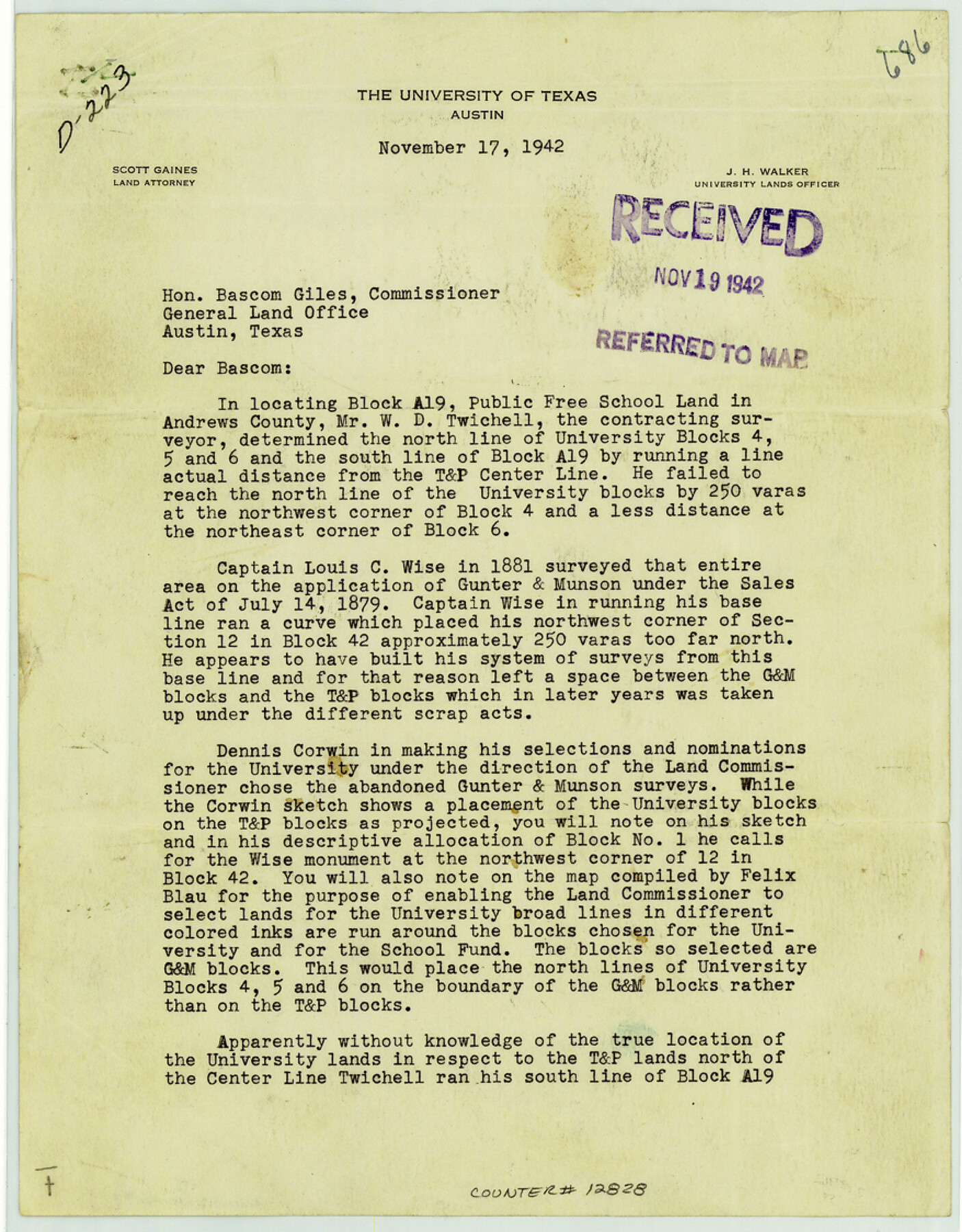
Andrews County Sketch File 7
[Letter from J.H. Walker regarding Block A-19]
- 
                          Map/Doc
12828
 - 
                            Collection
General Map Collection
 - 
                            Object Dates
1942/11/17 (Creation Date)
1942/11/19 (File Date)
 - 
                            People and Organizations
J.H. Walker (Author)
 - 
                            Counties
Andrews
 - 
                            Subjects
Surveying Sketch File
 - 
                            Height x Width
11.2 x 8.8 inches
28.4 x 22.4 cm
 - 
                            Medium
paper, print
 
Part of: General Map Collection
            Brooks County Working Sketch 19


                                            Print $20.00                    
                                             -                         Digital $50.00                                    
                Brooks County Working Sketch 19
1983
Size 31.7 x 18.4 inches
                                Map/Doc 67803
            
            University Lands Blocks 38 to 57, Crockett-Reagan-Irion-Schleicher-Counties


                                            Print $40.00                    
                                             -                         Digital $50.00                                    
                University Lands Blocks 38 to 57, Crockett-Reagan-Irion-Schleicher-Counties
1937
Size 34.2 x 52.7 inches
                                Map/Doc 2444
            
            Map of the Line of the H. & Texas Cen. Railway from the Navasota River, 72 1/2 Miles from Houston, to Corsicana in Navarro Co., 211 mls from Houston


                                            Print $40.00                    
                                             -                         Digital $50.00                                    
                Map of the Line of the H. & Texas Cen. Railway from the Navasota River, 72 1/2 Miles from Houston, to Corsicana in Navarro Co., 211 mls from Houston
Size 39.2 x 61.4 inches
                                Map/Doc 64086
            
            Mills County Boundary File 4


                                            Print $40.00                    
                                             -                         Digital $50.00                                    
                Mills County Boundary File 4
Size 52.1 x 13.3 inches
                                Map/Doc 57293
            
            Hardeman County Sketch File A


                                            Print $14.00                    
                                             -                         Digital $50.00                                    
                Hardeman County Sketch File A
1884
Size 12.7 x 8.1 inches
                                Map/Doc 25039
            
            Foard County Sketch File 19


                                            Print $20.00                    
                                             -                         Digital $50.00                                    
                Foard County Sketch File 19
1899
Size 17.7 x 16.5 inches
                                Map/Doc 11493
            
            Pecos County Sketch File 95


                                            Print $6.00                    
                                             -                         Digital $50.00                                    
                Pecos County Sketch File 95
1956
Size 11.2 x 8.8 inches
                                Map/Doc 33995
            
            Map of Eastland Co.


                                            Print $20.00                    
                                             -                         Digital $50.00                                    
                Map of Eastland Co.
1896
Size 40.0 x 42.8 inches
                                Map/Doc 78411
            
            Coke County Rolled Sketch 7


                                            Print $20.00                    
                                             -                         Digital $50.00                                    
                Coke County Rolled Sketch 7
Size 19.0 x 24.1 inches
                                Map/Doc 5506
            
            Palo Pinto County Working Sketch 13


                                            Print $20.00                    
                                             -                         Digital $50.00                                    
                Palo Pinto County Working Sketch 13
1947
Size 27.4 x 24.2 inches
                                Map/Doc 71396
            
            Sketch of Sabine Lake and Pass


                                            Print $20.00                    
                                             -                         Digital $50.00                                    
                Sketch of Sabine Lake and Pass
1840
Size 24.8 x 18.2 inches
                                Map/Doc 72725
            
            Jackson County Working Sketch 13


                                            Print $20.00                    
                                             -                         Digital $50.00                                    
                Jackson County Working Sketch 13
1994
Size 22.2 x 30.3 inches
                                Map/Doc 66461
            You may also like
            Nueces County NRC Article 33.136 Location Key Sheet


                                            Print $20.00                    
                                             -                         Digital $50.00                                    
                Nueces County NRC Article 33.136 Location Key Sheet
1975
Size 27.0 x 23.0 inches
                                Map/Doc 88585
            
            Intracoastal Waterway in Texas - Corpus Christi to Point Isabel including Arroyo Colorado to Mo. Pac. R.R. Bridge Near Harlingen


                                            Print $20.00                    
                                             -                         Digital $50.00                                    
                Intracoastal Waterway in Texas - Corpus Christi to Point Isabel including Arroyo Colorado to Mo. Pac. R.R. Bridge Near Harlingen
1933
Size 40.9 x 27.8 inches
                                Map/Doc 61874
            
            Dimmit County Sketch File 37


                                            Print $6.00                    
                                             -                         Digital $50.00                                    
                Dimmit County Sketch File 37
1894
Size 10.4 x 12.7 inches
                                Map/Doc 21161
            
            O'Neall Terrace, a Re-Subdivision of Blocks 37-38-39-40-43-44-45-46-110-112-113-114 and Parts of Blocks 111 and 115, McCrummens Second Addition to the City of Lubbock, Texas


                                            Print $20.00                    
                                             -                         Digital $50.00                                    
                O'Neall Terrace, a Re-Subdivision of Blocks 37-38-39-40-43-44-45-46-110-112-113-114 and Parts of Blocks 111 and 115, McCrummens Second Addition to the City of Lubbock, Texas
Size 22.6 x 27.5 inches
                                Map/Doc 92743
            
            General Highway Map.  Detail of Cities and Towns in Wharton County, Texas


                                            Print $20.00                    
                                    
                General Highway Map. Detail of Cities and Towns in Wharton County, Texas
1961
Size 18.3 x 24.8 inches
                                Map/Doc 79707
            
            Coke County Boundary File Index


                                            Print $2.00                    
                                             -                         Digital $50.00                                    
                Coke County Boundary File Index
Size 8.9 x 14.2 inches
                                Map/Doc 65461
            
            Flight Mission No. BRA-17M, Frame 5, Jefferson County


                                            Print $20.00                    
                                             -                         Digital $50.00                                    
                Flight Mission No. BRA-17M, Frame 5, Jefferson County
1953
Size 18.7 x 22.4 inches
                                Map/Doc 85785
            
            Pecos County Sketch File 116


                                            Print $6.00                    
                                             -                         Digital $50.00                                    
                Pecos County Sketch File 116
1913
Size 10.9 x 8.8 inches
                                Map/Doc 34092
            
            Map of San Leon, Amos Edwards League, Galveston County, Texas


                                            Print $20.00                    
                                             -                         Digital $50.00                                    
                Map of San Leon, Amos Edwards League, Galveston County, Texas
1911
Size 22.9 x 14.1 inches
                                Map/Doc 3037
            
            Map of Goliad County Texas


                                            Print $20.00                    
                                             -                         Digital $50.00                                    
                Map of Goliad County Texas
1879
Size 19.1 x 21.2 inches
                                Map/Doc 3589
            
            Terrell County Working Sketch 12


                                            Print $20.00                    
                                             -                         Digital $50.00                                    
                Terrell County Working Sketch 12
1926
Size 18.3 x 21.0 inches
                                Map/Doc 62161
            
            Map of Hill County


                                            Print $20.00                    
                                             -                         Digital $50.00                                    
                Map of Hill County
1884
Size 47.2 x 36.8 inches
                                Map/Doc 16851