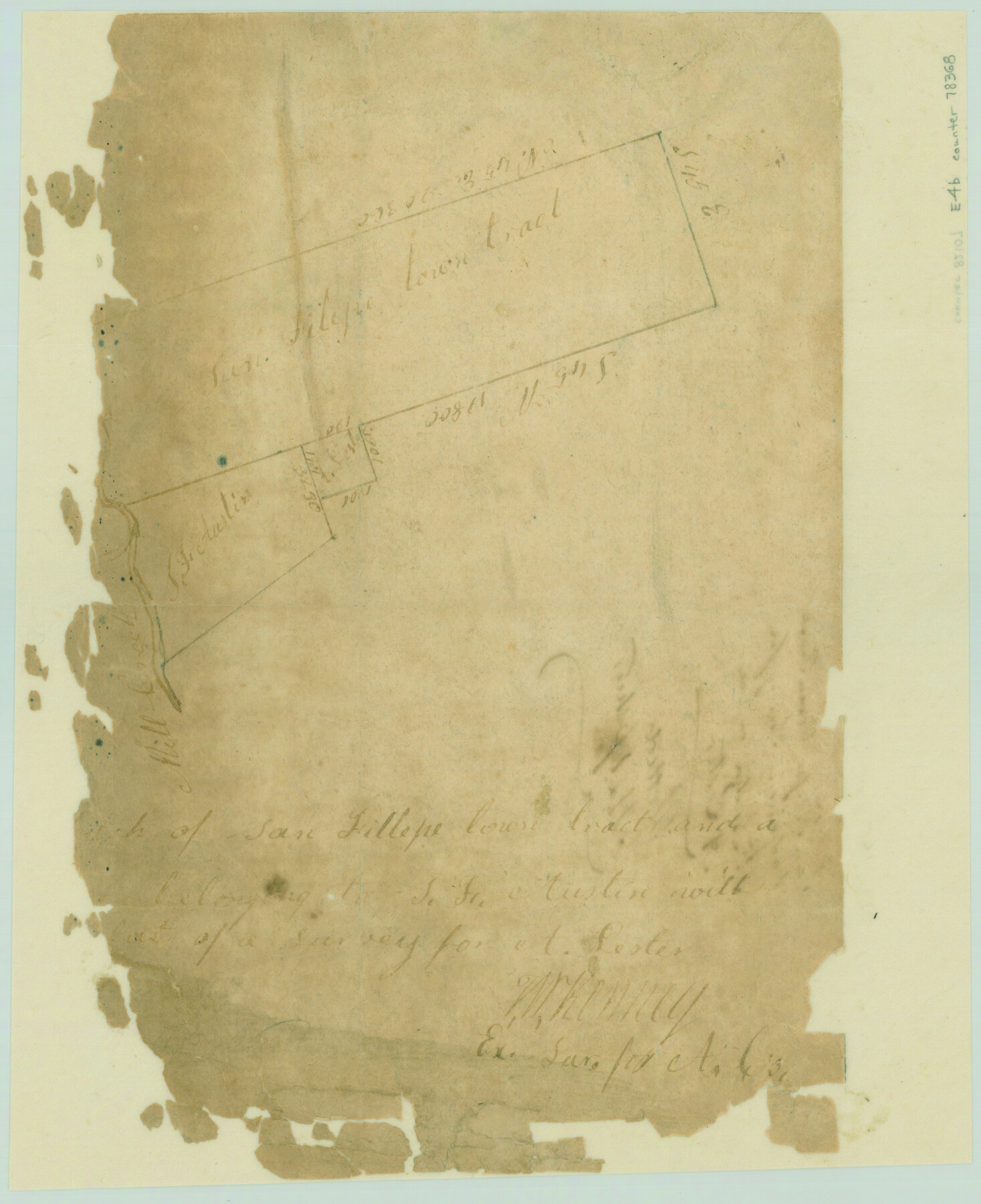
San Felipe Town Tract & Adjoining Survey for S. F. Austin and A. Lester
Atlas E, Sketch 4b (E-4b)
E-4b
-
Map/Doc
78368
-
Collection
General Map Collection
-
Counties
Austin
-
Subjects
Atlas
-
Height x Width
9.9 x 8.1 inches
25.1 x 20.6 cm
-
Medium
paper, manuscript
-
Comments
Conserved in 2004.
-
Features
San Felipe Town Tract
Mill Creek
Part of: General Map Collection
Maps of Gulf Intracoastal Waterway, Texas - Sabine River to the Rio Grande and connecting waterways including ship channels

Print $20.00
- Digital $50.00
Maps of Gulf Intracoastal Waterway, Texas - Sabine River to the Rio Grande and connecting waterways including ship channels
1966
Size 14.7 x 21.0 inches
Map/Doc 61992
Rockwall County Working Sketch Graphic Index

Print $20.00
- Digital $50.00
Rockwall County Working Sketch Graphic Index
1941
Size 30.0 x 23.5 inches
Map/Doc 76686
Matagorda County Working Sketch 10

Print $20.00
- Digital $50.00
Matagorda County Working Sketch 10
1958
Size 27.8 x 33.3 inches
Map/Doc 70868
Marion County Working Sketch 24

Print $20.00
- Digital $50.00
Marion County Working Sketch 24
1960
Size 21.4 x 26.4 inches
Map/Doc 70800
Fort Bend County Rolled Sketch 9

Print $20.00
- Digital $50.00
Fort Bend County Rolled Sketch 9
1920
Size 21.0 x 24.7 inches
Map/Doc 5899
Flight Mission No. CRC-5R, Frame 24, Chambers County

Print $20.00
- Digital $50.00
Flight Mission No. CRC-5R, Frame 24, Chambers County
1956
Size 18.7 x 22.4 inches
Map/Doc 84946
Kent County Working Sketch 10

Print $20.00
- Digital $50.00
Kent County Working Sketch 10
Size 34.1 x 43.0 inches
Map/Doc 70017
Hood County Sketch File 22

Print $6.00
- Digital $50.00
Hood County Sketch File 22
Size 15.7 x 9.3 inches
Map/Doc 26615
Coke County Rolled Sketch 25

Print $20.00
- Digital $50.00
Coke County Rolled Sketch 25
1974
Size 24.9 x 24.3 inches
Map/Doc 5525
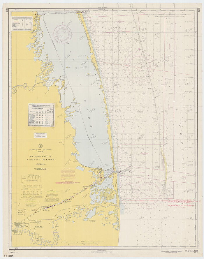
Southern Part of Laguna Madre
Print $20.00
- Digital $50.00
Southern Part of Laguna Madre
1966
Size 44.2 x 34.8 inches
Map/Doc 73539
Flight Mission No. CGI-3G, Frame 12, Cameron County

Print $20.00
- Digital $50.00
Flight Mission No. CGI-3G, Frame 12, Cameron County
1950
Size 19.3 x 19.0 inches
Map/Doc 84531
Edwards County Working Sketch 120

Print $40.00
- Digital $50.00
Edwards County Working Sketch 120
1975
Size 25.0 x 48.9 inches
Map/Doc 68996
You may also like
Hall County Sketch File 14

Print $20.00
- Digital $50.00
Hall County Sketch File 14
1882
Size 20.9 x 32.9 inches
Map/Doc 11607
Presidio County Rolled Sketch T-3

Print $20.00
- Digital $50.00
Presidio County Rolled Sketch T-3
Size 36.6 x 28.9 inches
Map/Doc 7417
[Yoakum and Gaines County Line Along Block D in Yoakum and Blocks A6, AX, C35 and C34 in Gaines]
![89691, [Yoakum and Gaines County Line Along Block D in Yoakum and Blocks A6, AX, C35 and C34 in Gaines], Twichell Survey Records](https://historictexasmaps.com/wmedia_w700/maps/89691-1.tif.jpg)
Print $40.00
- Digital $50.00
[Yoakum and Gaines County Line Along Block D in Yoakum and Blocks A6, AX, C35 and C34 in Gaines]
1924
Size 54.9 x 12.3 inches
Map/Doc 89691
Shackelford County Rolled Sketch 4

Print $20.00
- Digital $50.00
Shackelford County Rolled Sketch 4
Size 38.8 x 47.7 inches
Map/Doc 9916
Zapata County Working Sketch 5

Print $20.00
- Digital $50.00
Zapata County Working Sketch 5
1940
Size 23.4 x 18.3 inches
Map/Doc 62056
Flight Mission No. DIX-8P, Frame 59, Aransas County

Print $20.00
- Digital $50.00
Flight Mission No. DIX-8P, Frame 59, Aransas County
1956
Size 18.7 x 22.4 inches
Map/Doc 83890
Bailey County Sketch File 18

Print $40.00
- Digital $50.00
Bailey County Sketch File 18
Size 13.3 x 22.9 inches
Map/Doc 10889
Duval County Sketch File 8

Print $6.00
- Digital $50.00
Duval County Sketch File 8
1869
Size 14.1 x 11.3 inches
Map/Doc 21296
San Saba County Sketch File 5

Print $4.00
- Digital $50.00
San Saba County Sketch File 5
Size 12.8 x 8.0 inches
Map/Doc 36412
Kerr County Working Sketch 30

Print $20.00
- Digital $50.00
Kerr County Working Sketch 30
1973
Size 29.8 x 28.9 inches
Map/Doc 70061
Hartley County Boundary File 4

Print $56.00
- Digital $50.00
Hartley County Boundary File 4
Size 8.6 x 20.7 inches
Map/Doc 54495
San Jacinto County Working Sketch 12

Print $20.00
- Digital $50.00
San Jacinto County Working Sketch 12
1935
Size 33.4 x 37.3 inches
Map/Doc 63725