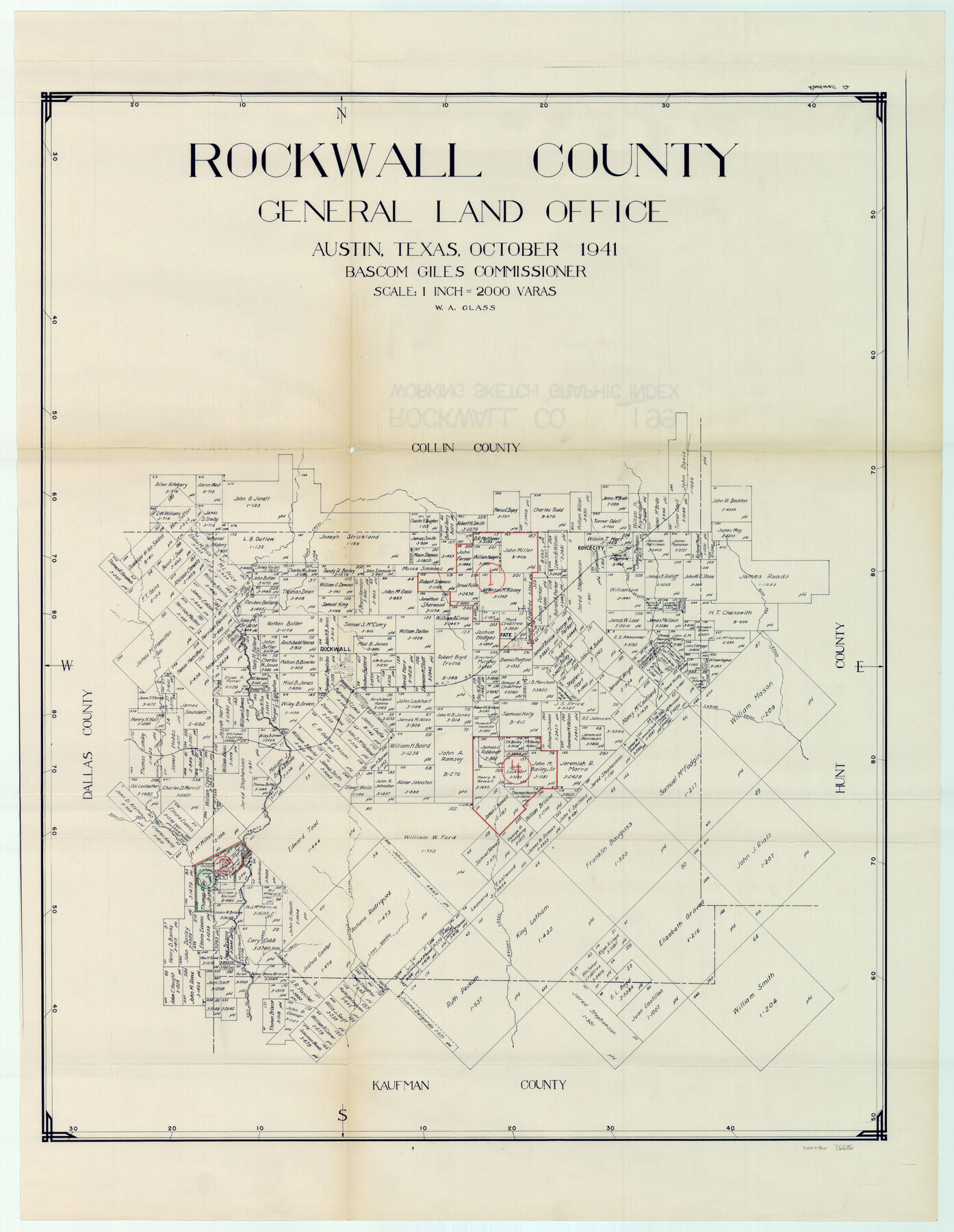
Rockwall County Working Sketch Graphic Index
-
Map/Doc
76686
-
Collection
General Map Collection
-
Object Dates
10/1941 (Creation Date)
-
People and Organizations
W.A. Glass (Draftsman)
-
Counties
Rockwall
-
Subjects
County Surveying Working Sketch
-
Height x Width
30.0 x 23.5 inches
76.2 x 59.7 cm
-
Scale
1" = 2000 varas
Part of: General Map Collection
Flight Mission No. DCL-7C, Frame 46, Kenedy County

Print $20.00
- Digital $50.00
Flight Mission No. DCL-7C, Frame 46, Kenedy County
1943
Size 15.4 x 15.3 inches
Map/Doc 86034
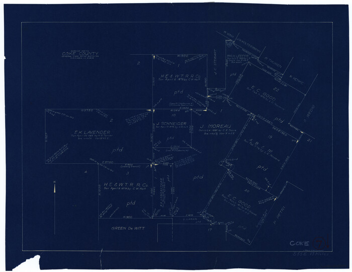
Coke County Working Sketch 7
Print $20.00
- Digital $50.00
Coke County Working Sketch 7
1924
Size 15.8 x 20.4 inches
Map/Doc 68044
Johnson's New Military Map of the United States Showing the Forts, Military Posts & c. with Enlarged Plans of Southern Harbors

Print $20.00
- Digital $50.00
Johnson's New Military Map of the United States Showing the Forts, Military Posts & c. with Enlarged Plans of Southern Harbors
1863
Size 17.7 x 23.3 inches
Map/Doc 93289
Nolan County Working Sketch 3

Print $20.00
- Digital $50.00
Nolan County Working Sketch 3
1947
Size 23.5 x 17.2 inches
Map/Doc 71294
[Surveys along Cow and Deer Creeks]
![306, [Surveys along Cow and Deer Creeks], General Map Collection](https://historictexasmaps.com/wmedia_w700/maps/306.tif.jpg)
Print $2.00
- Digital $50.00
[Surveys along Cow and Deer Creeks]
1845
Size 15.8 x 8.6 inches
Map/Doc 306
Flight Mission No. CUG-1P, Frame 111, Kleberg County

Print $20.00
- Digital $50.00
Flight Mission No. CUG-1P, Frame 111, Kleberg County
1956
Size 18.5 x 22.2 inches
Map/Doc 86161
Childress County

Print $20.00
- Digital $50.00
Childress County
1892
Size 24.7 x 19.6 inches
Map/Doc 3391
Map of the State of Coahuila and Texas

Map of the State of Coahuila and Texas
1834
Size 13.3 x 14.9 inches
Map/Doc 96969
Duval County Sketch File 35a

Print $26.00
- Digital $50.00
Duval County Sketch File 35a
Size 11.3 x 8.9 inches
Map/Doc 21371
Presidio County Sketch File 77

Print $20.00
- Digital $50.00
Presidio County Sketch File 77
Size 21.8 x 17.9 inches
Map/Doc 11721
Foard County Sketch File 29

Print $20.00
- Digital $50.00
Foard County Sketch File 29
Size 18.9 x 29.4 inches
Map/Doc 11494
Pecos County Rolled Sketch 82

Print $20.00
- Digital $50.00
Pecos County Rolled Sketch 82
1930
Size 29.0 x 26.4 inches
Map/Doc 10192
You may also like
Hutchinson County Working Sketch 43

Print $20.00
- Digital $50.00
Hutchinson County Working Sketch 43
1978
Size 26.6 x 22.3 inches
Map/Doc 66403
Somervell County Working Sketch 6

Print $20.00
- Digital $50.00
Somervell County Working Sketch 6
1992
Size 23.2 x 21.5 inches
Map/Doc 63910
Presidio County Rolled Sketch 3A

Print $20.00
- Digital $50.00
Presidio County Rolled Sketch 3A
Size 18.5 x 16.8 inches
Map/Doc 7327

Houston County

Print $40.00
- Digital $50.00
Houston County
1944
Size 50.3 x 50.3 inches
Map/Doc 73184
Nueces County Rolled Sketch 101

Print $88.00
Nueces County Rolled Sketch 101
1985
Size 18.2 x 24.6 inches
Map/Doc 7061
[Sketch of Railroad Switchyard stretching from Ross to Monroe Streets, Amarillo, Texas]
![91830, [Sketch of Railroad Switchyard stretching from Ross to Monroe Streets, Amarillo, Texas], Twichell Survey Records](https://historictexasmaps.com/wmedia_w700/maps/91830-1.tif.jpg)
Print $20.00
- Digital $50.00
[Sketch of Railroad Switchyard stretching from Ross to Monroe Streets, Amarillo, Texas]
Size 10.0 x 36.1 inches
Map/Doc 91830
Map of Hall County

Print $20.00
- Digital $50.00
Map of Hall County
1895
Size 25.2 x 20.2 inches
Map/Doc 3619
Presidio County Sketch File 122

Print $22.00
- Digital $50.00
Presidio County Sketch File 122
2010
Size 11.0 x 8.5 inches
Map/Doc 89604
Presidio County Rolled Sketch BB

Print $20.00
- Digital $50.00
Presidio County Rolled Sketch BB
1937
Size 26.3 x 27.1 inches
Map/Doc 7407
Parker County Boundary File 2

Print $8.00
- Digital $50.00
Parker County Boundary File 2
Size 11.2 x 8.8 inches
Map/Doc 57835
