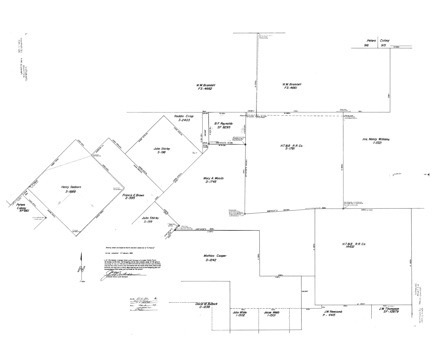
Shackelford County Rolled Sketch 4
[Survey plat showing Mary A. Woods, D-1745 and surrounding surveys relating to MA-74698]
-
Map/Doc
9916
-
Collection
General Map Collection
-
Object Dates
1984/2/13 (Survey Date)
1984/3/2 (File Date)
-
People and Organizations
James E. Mortensen (Surveyor/Engineer)
-
Counties
Shackelford
-
Subjects
Surveying Rolled Sketch
-
Height x Width
38.8 x 47.7 inches
98.6 x 121.2 cm
-
Scale
1" = 180 varas
Part of: General Map Collection
Val Verde County Sketch File 51b

Print $6.00
- Digital $50.00
Val Verde County Sketch File 51b
Size 10.1 x 8.8 inches
Map/Doc 39329
Pecos County Sketch File 47

Print $8.00
- Digital $50.00
Pecos County Sketch File 47
1935
Size 11.4 x 8.5 inches
Map/Doc 33759
Motley County Sketch File 3 (N)

Print $22.00
- Digital $50.00
Motley County Sketch File 3 (N)
Size 9.1 x 13.0 inches
Map/Doc 31998
Red River County Sketch File 20

Print $4.00
- Digital $50.00
Red River County Sketch File 20
Size 8.2 x 10.1 inches
Map/Doc 35152
Chambers County Working Sketch 6

Print $20.00
- Digital $50.00
Chambers County Working Sketch 6
1938
Size 14.3 x 19.7 inches
Map/Doc 67989
San Saba County Sketch File 3

Print $4.00
- Digital $50.00
San Saba County Sketch File 3
1848
Size 12.5 x 7.9 inches
Map/Doc 36408
Sabine County Working Sketch 13

Print $20.00
- Digital $50.00
Sabine County Working Sketch 13
1935
Size 35.3 x 44.2 inches
Map/Doc 63684
Edwards County Sketch File 27

Print $6.00
- Digital $50.00
Edwards County Sketch File 27
1913
Size 10.5 x 16.5 inches
Map/Doc 21755
Schleicher County Sketch File 44

Print $4.00
- Digital $50.00
Schleicher County Sketch File 44
1950
Size 8.9 x 14.4 inches
Map/Doc 36550
Marion County Sketch File 6

Print $24.00
- Digital $50.00
Marion County Sketch File 6
Size 9.3 x 7.2 inches
Map/Doc 30570
Map of Kinney County

Print $20.00
- Digital $50.00
Map of Kinney County
1875
Size 25.9 x 34.2 inches
Map/Doc 3773
Chambers County Sketch File 5

Print $2.00
- Digital $50.00
Chambers County Sketch File 5
Size 7.2 x 6.3 inches
Map/Doc 17539
You may also like
Liberty County Rolled Sketch WC

Print $107.00
- Digital $50.00
Liberty County Rolled Sketch WC
1934
Size 10.4 x 15.3 inches
Map/Doc 46561
Crane County Working Sketch 16

Print $20.00
- Digital $50.00
Crane County Working Sketch 16
1955
Size 42.8 x 22.0 inches
Map/Doc 68293
Intracoastal Waterway in Texas - Corpus Christi to Point Isabel including Arroyo Colorado to Mo. Pac. R.R. Bridge Near Harlingen

Print $20.00
- Digital $50.00
Intracoastal Waterway in Texas - Corpus Christi to Point Isabel including Arroyo Colorado to Mo. Pac. R.R. Bridge Near Harlingen
1933
Size 28.1 x 41.2 inches
Map/Doc 61845
Kleberg County Aerial Photograph Index Sheet 3

Print $20.00
- Digital $50.00
Kleberg County Aerial Photograph Index Sheet 3
1956
Size 19.1 x 23.4 inches
Map/Doc 83720
Montgomery County Rolled Sketch 49

Print $20.00
- Digital $50.00
Montgomery County Rolled Sketch 49
2015
Size 36.1 x 23.9 inches
Map/Doc 95186
Crockett County Sketch File 65

Print $20.00
- Digital $50.00
Crockett County Sketch File 65
1927
Size 23.2 x 36.6 inches
Map/Doc 11230
Flight Mission No. DCL-6C, Frame 126, Kenedy County

Print $20.00
- Digital $50.00
Flight Mission No. DCL-6C, Frame 126, Kenedy County
1943
Size 18.5 x 22.3 inches
Map/Doc 85956
Plat of a survey of the North part of section 16, Block 362, Martha McBride, Presidio County, Texas

Print $6.00
- Digital $50.00
Plat of a survey of the North part of section 16, Block 362, Martha McBride, Presidio County, Texas
1989
Size 25.5 x 35.0 inches
Map/Doc 60521
Van Zandt County Sketch File 23

Print $4.00
- Digital $50.00
Van Zandt County Sketch File 23
1858
Size 6.8 x 8.2 inches
Map/Doc 39437
Harris County Rolled Sketch WHW

Print $20.00
- Digital $50.00
Harris County Rolled Sketch WHW
1930
Size 20.7 x 41.6 inches
Map/Doc 6466
Part of Lea County

Print $20.00
- Digital $50.00
Part of Lea County
Size 42.2 x 35.5 inches
Map/Doc 92438
Texas Boundary Line

Print $20.00
- Digital $50.00
Texas Boundary Line
Size 21.4 x 11.8 inches
Map/Doc 92076