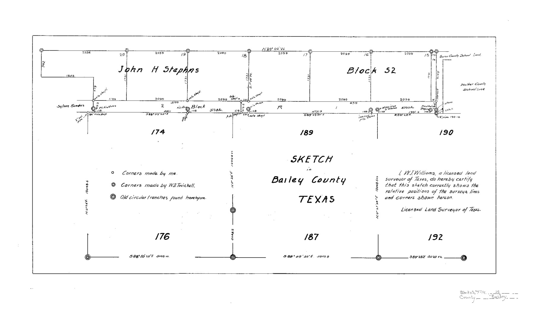
Bailey County Sketch File 18
Sketch in Bailey County, Texas [showing Block S2, John H. Stephens]
-
Map/Doc
10889
-
Collection
General Map Collection
-
People and Organizations
W.J. Williams (Surveyor/Engineer)
-
Counties
Bailey
-
Subjects
Surveying Sketch File
-
Height x Width
13.3 x 22.9 inches
33.8 x 58.2 cm
-
Medium
blueprint/diazo
Part of: General Map Collection

Hudspeth County Working Sketch 5

Print $20.00
- Digital $50.00
Hudspeth County Working Sketch 5
1921
Size 27.8 x 38.8 inches
Map/Doc 66286
West Part of Jeff Davis Co.

Print $20.00
- Digital $50.00
West Part of Jeff Davis Co.
1977
Size 31.0 x 41.1 inches
Map/Doc 77328
Grayson County Working Sketch 17

Print $20.00
- Digital $50.00
Grayson County Working Sketch 17
1955
Size 16.0 x 42.5 inches
Map/Doc 63256
Kimble County Working Sketch 57

Print $6.00
- Digital $50.00
Kimble County Working Sketch 57
1958
Size 20.3 x 30.5 inches
Map/Doc 70125
Marion County Working Sketch 41

Print $40.00
- Digital $50.00
Marion County Working Sketch 41
1996
Size 34.0 x 48.5 inches
Map/Doc 70817
Crockett County Rolled Sketch 29

Print $20.00
- Digital $50.00
Crockett County Rolled Sketch 29
1927
Size 22.0 x 36.9 inches
Map/Doc 5781
Guadalupe County Sketch File 20

Print $6.00
- Digital $50.00
Guadalupe County Sketch File 20
1912
Size 11.1 x 8.7 inches
Map/Doc 24699
Trinity River, Dallas Elevation Sheet

Print $20.00
- Digital $50.00
Trinity River, Dallas Elevation Sheet
1913
Size 26.6 x 24.1 inches
Map/Doc 65258
Flight Mission No. CLL-1N, Frame 8, Willacy County

Print $20.00
- Digital $50.00
Flight Mission No. CLL-1N, Frame 8, Willacy County
1954
Size 18.3 x 22.1 inches
Map/Doc 86995
Flight Mission No. DAG-14K, Frame 145, Matagorda County

Print $20.00
- Digital $50.00
Flight Mission No. DAG-14K, Frame 145, Matagorda County
1952
Size 18.6 x 22.6 inches
Map/Doc 86312
Limestone County Sketch File 24

Print $8.00
- Digital $50.00
Limestone County Sketch File 24
1942
Size 11.2 x 8.8 inches
Map/Doc 30206
You may also like
Culberson County Rolled Sketch 61

Print $20.00
- Digital $50.00
Culberson County Rolled Sketch 61
1985
Size 24.7 x 19.0 inches
Map/Doc 5677
Howard County Working Sketch 1

Print $20.00
- Digital $50.00
Howard County Working Sketch 1
1941
Size 19.7 x 25.1 inches
Map/Doc 66267
Old Miscellaneous File 6

Print $4.00
- Digital $50.00
Old Miscellaneous File 6
1847
Size 4.2 x 7.6 inches
Map/Doc 75420
Montgomery County

Print $20.00
- Digital $50.00
Montgomery County
1861
Size 18.4 x 22.3 inches
Map/Doc 3890
Hutchinson County

Print $20.00
- Digital $50.00
Hutchinson County
1884
Size 13.7 x 15.3 inches
Map/Doc 91137
Smith County Sketch File 1

Print $4.00
- Digital $50.00
Smith County Sketch File 1
Size 9.0 x 10.5 inches
Map/Doc 36746

Sketch Showing D. Rubin Surveys

Print $20.00
- Digital $50.00
Sketch Showing D. Rubin Surveys
1926
Size 35.1 x 24.5 inches
Map/Doc 91165
Callahan County Working Sketch Graphic Index

Print $20.00
- Digital $50.00
Callahan County Working Sketch Graphic Index
1969
Size 41.3 x 33.4 inches
Map/Doc 76485
Jackson County Sketch File 27

Print $20.00
- Digital $50.00
Jackson County Sketch File 27
1938
Size 25.6 x 24.8 inches
Map/Doc 11847
[Block M21, B. S. & F. Block 3, I. & G. N. Block 4, and Part of Block 46]
![91178, [Block M21, B. S. & F. Block 3, I. & G. N. Block 4, and Part of Block 46], Twichell Survey Records](https://historictexasmaps.com/wmedia_w700/maps/91178-1.tif.jpg)
Print $20.00
- Digital $50.00
[Block M21, B. S. & F. Block 3, I. & G. N. Block 4, and Part of Block 46]
Size 19.6 x 17.9 inches
Map/Doc 91178
Flight Mission No. DQN-1K, Frame 103, Calhoun County

Print $20.00
- Digital $50.00
Flight Mission No. DQN-1K, Frame 103, Calhoun County
1953
Size 18.5 x 22.1 inches
Map/Doc 84170