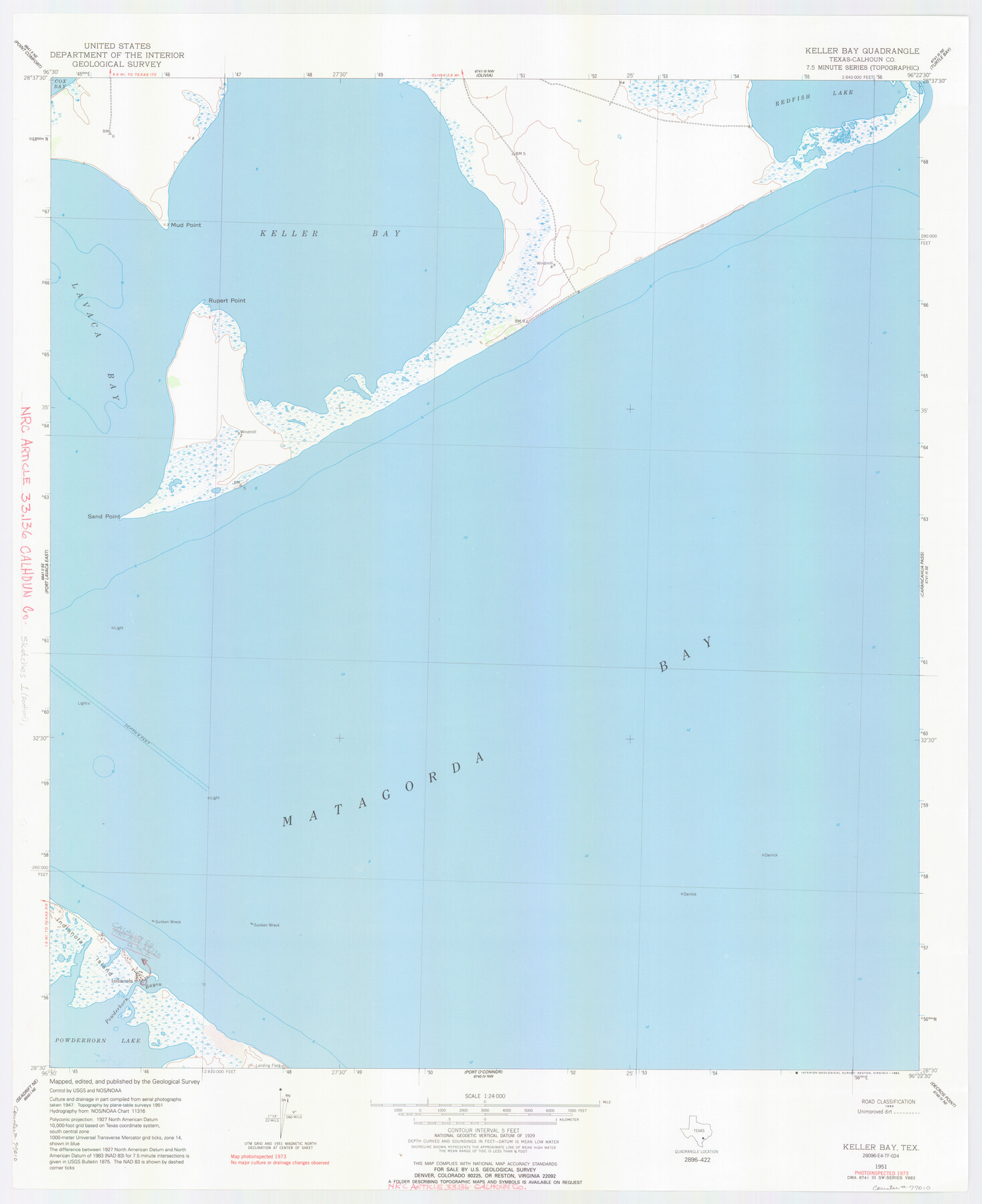
Calhoun County NRC Article 33.136 Location Key Sheet
Keller Bay Quadrangle
-
Map/Doc
77010
-
Collection
General Map Collection
-
Object Dates
1973 (Creation Date)
-
People and Organizations
U. S. Geological Survey (Publisher)
U. S. Geological Survey (Printer)
-
Counties
Calhoun
-
Subjects
Surveying CBS
-
Height x Width
27.0 x 22.0 inches
68.6 x 55.9 cm
Part of: General Map Collection
Motley County Working Sketch 11

Print $20.00
- Digital $50.00
Motley County Working Sketch 11
1989
Size 28.5 x 33.0 inches
Map/Doc 71216
Terrell County Sketch File 1

Print $78.00
- Digital $50.00
Terrell County Sketch File 1
1881
Size 9.1 x 8.8 inches
Map/Doc 37870
Flight Mission No. DAG-23K, Frame 169, Matagorda County

Print $20.00
- Digital $50.00
Flight Mission No. DAG-23K, Frame 169, Matagorda County
1953
Size 16.0 x 15.8 inches
Map/Doc 86507
Brewster County Working Sketch 92

Print $40.00
- Digital $50.00
Brewster County Working Sketch 92
1975
Size 61.9 x 39.4 inches
Map/Doc 67692
Flight Mission No. DIX-6P, Frame 116, Aransas County

Print $20.00
- Digital $50.00
Flight Mission No. DIX-6P, Frame 116, Aransas County
1956
Size 19.2 x 23.1 inches
Map/Doc 83822
Duval County Sketch File 32b

Print $6.00
- Digital $50.00
Duval County Sketch File 32b
Size 14.2 x 8.9 inches
Map/Doc 21339
Greater San Antonio & Surrounding Area

Greater San Antonio & Surrounding Area
Size 36.1 x 46.0 inches
Map/Doc 96869
Harbor of Brazos Santiago, Texas

Print $20.00
- Digital $50.00
Harbor of Brazos Santiago, Texas
1887
Size 27.3 x 18.3 inches
Map/Doc 72992
Northwest Part of Webb County

Print $40.00
- Digital $50.00
Northwest Part of Webb County
1984
Size 43.2 x 52.9 inches
Map/Doc 95669
Burnet County Boundary File 3

Print $18.00
- Digital $50.00
Burnet County Boundary File 3
Size 12.8 x 8.2 inches
Map/Doc 50863
Edwards County Sketch File 12c

Print $20.00
- Digital $50.00
Edwards County Sketch File 12c
Size 23.0 x 26.8 inches
Map/Doc 11425
Cottle County Working Sketch 8

Print $20.00
- Digital $50.00
Cottle County Working Sketch 8
1917
Size 26.9 x 29.7 inches
Map/Doc 68318
You may also like
[Traverse up the Brazos and Colorado River showing distance from county site to county site]
![2054, [Traverse up the Brazos and Colorado River showing distance from county site to county site], General Map Collection](https://historictexasmaps.com/wmedia_w700/maps/2054.tif.jpg)
Print $40.00
- Digital $50.00
[Traverse up the Brazos and Colorado River showing distance from county site to county site]
1871
Size 16.2 x 98.8 inches
Map/Doc 2054
Trinity County Sketch File 11

Print $8.00
- Digital $50.00
Trinity County Sketch File 11
1859
Size 6.2 x 6.2 inches
Map/Doc 38531
McMullen County Working Sketch 34

Print $20.00
- Digital $50.00
McMullen County Working Sketch 34
1959
Size 25.9 x 26.0 inches
Map/Doc 70735
Proceedings of The International (Water) Boundary Commission United States and Mexico Treaties of 1884 and 1889, Volume 2

Proceedings of The International (Water) Boundary Commission United States and Mexico Treaties of 1884 and 1889, Volume 2
Map/Doc 83145
Kinney County Sketch File 37

Print $20.00
- Digital $50.00
Kinney County Sketch File 37
Size 19.0 x 23.4 inches
Map/Doc 11950
Bee County Working Sketch 20

Print $20.00
- Digital $50.00
Bee County Working Sketch 20
1982
Size 23.6 x 21.3 inches
Map/Doc 67270
Presidio County Working Sketch 130

Print $20.00
- Digital $50.00
Presidio County Working Sketch 130
1989
Size 22.1 x 43.1 inches
Map/Doc 71808
[Sketch showing University Lands in West Texas]
![62964, [Sketch showing University Lands in West Texas], General Map Collection](https://historictexasmaps.com/wmedia_w700/maps/62964-1.tif.jpg)
Print $20.00
- Digital $50.00
[Sketch showing University Lands in West Texas]
Size 20.5 x 27.8 inches
Map/Doc 62964
Foard County Sketch File 4

Print $5.00
- Digital $50.00
Foard County Sketch File 4
Size 12.4 x 9.5 inches
Map/Doc 22806
Real County Working Sketch 36

Print $20.00
- Digital $50.00
Real County Working Sketch 36
1950
Size 24.7 x 35.9 inches
Map/Doc 71928
[Portion of Blocks C and C2]
![90696, [Portion of Blocks C and C2], Twichell Survey Records](https://historictexasmaps.com/wmedia_w700/maps/90696-1.tif.jpg)
Print $20.00
- Digital $50.00
[Portion of Blocks C and C2]
1906
Size 24.4 x 12.4 inches
Map/Doc 90696
Maverick County Sketch File 13a

Print $6.00
- Digital $50.00
Maverick County Sketch File 13a
1883
Size 14.1 x 8.8 inches
Map/Doc 31108