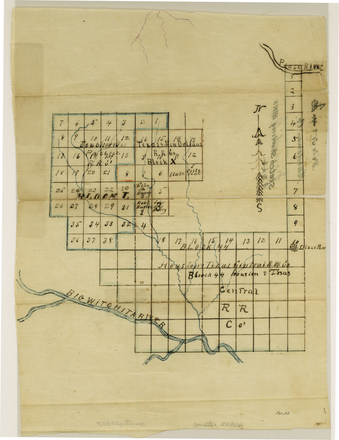
Foard County Sketch File 4
[Sketch showing Blocks 44, L and X between Pease River and Big Wichita River]
-
Map/Doc
22806
-
Collection
General Map Collection
-
Counties
Foard
-
Subjects
Surveying Sketch File
-
Height x Width
12.4 x 9.5 inches
31.5 x 24.1 cm
-
Medium
paper, manuscript
-
Features
Pease River
Dixie Peak
Big Witchita [sic] River
Part of: General Map Collection
Houston, Capital of Texas, 1837

Print $21.65
Houston, Capital of Texas, 1837
2007
Size 17.4 x 24.3 inches
Map/Doc 89272
Kimble County Working Sketch 26

Print $20.00
- Digital $50.00
Kimble County Working Sketch 26
1934
Size 24.3 x 18.4 inches
Map/Doc 70094
Flight Mission No. CGI-1N, Frame 182, Cameron County

Print $20.00
- Digital $50.00
Flight Mission No. CGI-1N, Frame 182, Cameron County
1955
Size 18.6 x 22.3 inches
Map/Doc 84517
The Great Texas Coastal Birding Trail, Central Texas Coast

The Great Texas Coastal Birding Trail, Central Texas Coast
Size 33.1 x 36.0 inches
Map/Doc 94339
Foard County Working Sketch 10

Print $20.00
- Digital $50.00
Foard County Working Sketch 10
1977
Size 32.0 x 43.7 inches
Map/Doc 69201
Duval County Rolled Sketch 37

Print $20.00
- Digital $50.00
Duval County Rolled Sketch 37
Size 19.8 x 16.5 inches
Map/Doc 5754
Map of Fort Worth & Denver City Railway

Print $40.00
- Digital $50.00
Map of Fort Worth & Denver City Railway
1880
Size 25.3 x 50.3 inches
Map/Doc 64416
Scurry County Rolled Sketch 8

Print $20.00
- Digital $50.00
Scurry County Rolled Sketch 8
1949
Size 35.1 x 19.1 inches
Map/Doc 7768
Denton County Working Sketch 2

Print $20.00
- Digital $50.00
Denton County Working Sketch 2
Size 21.2 x 17.7 inches
Map/Doc 68607
Llano County Sketch File 13

Print $4.00
- Digital $50.00
Llano County Sketch File 13
1891
Size 9.2 x 15.3 inches
Map/Doc 30387
Hill County Boundary File 45c

Print $64.00
- Digital $50.00
Hill County Boundary File 45c
Size 14.5 x 8.8 inches
Map/Doc 54784
Dickens County Rolled Sketch 13

Print $40.00
- Digital $50.00
Dickens County Rolled Sketch 13
1950
Size 43.4 x 53.7 inches
Map/Doc 45135
You may also like
Carta Esferica Del Reyno De Mexico y parte de la America Setentrional, Para inteligencia de la Obra intitulada: Descubrimiento y Conquista de la America

Print $20.00
- Digital $50.00
Carta Esferica Del Reyno De Mexico y parte de la America Setentrional, Para inteligencia de la Obra intitulada: Descubrimiento y Conquista de la America
1802
Size 15.1 x 20.5 inches
Map/Doc 97410
[Leagues 139 and 130]
![90440, [Leagues 139 and 130], Twichell Survey Records](https://historictexasmaps.com/wmedia_w700/maps/90440-1.tif.jpg)
Print $2.00
- Digital $50.00
[Leagues 139 and 130]
Size 7.9 x 12.5 inches
Map/Doc 90440
Harris County Rolled Sketch 81

Print $28.00
- Digital $50.00
Harris County Rolled Sketch 81
1956
Size 31.1 x 22.2 inches
Map/Doc 6117
Flight Mission No. CLL-1N, Frame 9, Willacy County

Print $20.00
- Digital $50.00
Flight Mission No. CLL-1N, Frame 9, Willacy County
1954
Size 18.4 x 22.1 inches
Map/Doc 86996
Railroad Track Map, T&PRRCo., Culberson County, Texas

Print $4.00
- Digital $50.00
Railroad Track Map, T&PRRCo., Culberson County, Texas
1910
Size 11.8 x 18.7 inches
Map/Doc 62826
Real County Rolled Sketch 12

Print $40.00
- Digital $50.00
Real County Rolled Sketch 12
Size 42.7 x 54.6 inches
Map/Doc 9836
Intracoastal Waterway in Texas - Corpus Christi to Point Isabel including Arroyo Colorado to Mo. Pac. R.R. Bridge Near Harlingen

Print $20.00
- Digital $50.00
Intracoastal Waterway in Texas - Corpus Christi to Point Isabel including Arroyo Colorado to Mo. Pac. R.R. Bridge Near Harlingen
1933
Size 27.5 x 40.6 inches
Map/Doc 61869
Edwards County Working Sketch 97

Print $20.00
- Digital $50.00
Edwards County Working Sketch 97
1969
Size 25.5 x 27.6 inches
Map/Doc 68973
La Salle County Rolled Sketch 26

Print $20.00
- Digital $50.00
La Salle County Rolled Sketch 26
1969
Size 23.6 x 24.7 inches
Map/Doc 6587
Atascosa County Rolled Sketch 5B2

Print $20.00
- Digital $50.00
Atascosa County Rolled Sketch 5B2
1910
Size 16.4 x 12.5 inches
Map/Doc 5091
The Coast of Texas

Print $20.00
- Digital $50.00
The Coast of Texas
1844
Size 18.3 x 26.9 inches
Map/Doc 72698
Boundary and Ownership map, Laguna Atascosa National Wildlife Refuge, Cameron and Willacy Counties, Texas

Print $40.00
- Digital $50.00
Boundary and Ownership map, Laguna Atascosa National Wildlife Refuge, Cameron and Willacy Counties, Texas
Size 72.7 x 43.0 inches
Map/Doc 60396