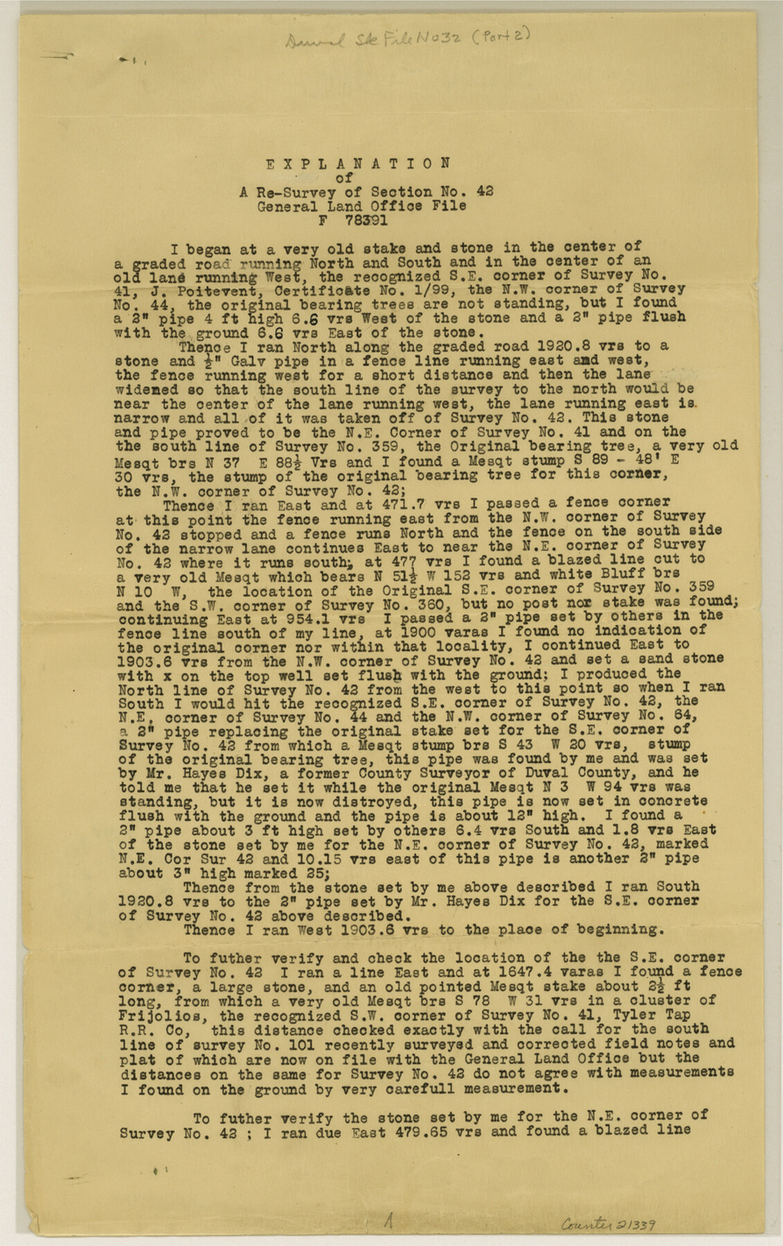
Duval County Sketch File 32b
[Explanation of a resurvey of section number 42]
-
Map/Doc
21339
-
Collection
General Map Collection
-
Object Dates
1932/11/29 (File Date)
-
People and Organizations
J.L. Dellis (Surveyor/Engineer)
Hayes Dix (Surveyor/Engineer)
-
Counties
Duval
-
Subjects
Surveying Sketch File
-
Height x Width
14.2 x 8.9 inches
36.1 x 22.6 cm
-
Medium
paper, print
Part of: General Map Collection
Sherman County Rolled Sketch 12

Print $40.00
- Digital $50.00
Sherman County Rolled Sketch 12
1951
Size 11.1 x 63.8 inches
Map/Doc 9929
Childress County

Print $20.00
- Digital $50.00
Childress County
1921
Size 43.8 x 32.6 inches
Map/Doc 66753
Hall County Sketch File C

Print $20.00
- Digital $50.00
Hall County Sketch File C
1905
Size 13.7 x 32.8 inches
Map/Doc 11614


[Map representing Townships 21, 20 and part of 19 of Range 17 and the corresponding ones in the 16th Range, according to the United States surveys showing the Boundary between the Republic of Texas and the United States of America]
![262, [Map representing Townships 21, 20 and part of 19 of Range 17 and the corresponding ones in the 16th Range, according to the United States surveys showing the Boundary between the Republic of Texas and the United States of America], General Map Collection](https://historictexasmaps.com/wmedia_w700/maps/262.tif.jpg)
Print $20.00
- Digital $50.00
[Map representing Townships 21, 20 and part of 19 of Range 17 and the corresponding ones in the 16th Range, according to the United States surveys showing the Boundary between the Republic of Texas and the United States of America]
1841
Size 19.5 x 15.4 inches
Map/Doc 262
Travis County Working Sketch 31

Print $20.00
- Digital $50.00
Travis County Working Sketch 31
1965
Size 31.2 x 35.6 inches
Map/Doc 69415
Coke County Sketch File 13

Print $40.00
- Digital $50.00
Coke County Sketch File 13
Size 17.5 x 13.1 inches
Map/Doc 18596
Hockley County Boundary File 2

Print $40.00
- Digital $50.00
Hockley County Boundary File 2
Size 23.8 x 6.8 inches
Map/Doc 54802
Flight Mission No. CGI-1N, Frame 217, Cameron County

Print $20.00
- Digital $50.00
Flight Mission No. CGI-1N, Frame 217, Cameron County
1955
Size 18.6 x 22.2 inches
Map/Doc 84526
Presidio County Rolled Sketch 33

Print $40.00
- Digital $50.00
Presidio County Rolled Sketch 33
Size 57.7 x 42.3 inches
Map/Doc 9772
Denton County Working Sketch 5

Print $20.00
- Digital $50.00
Denton County Working Sketch 5
1956
Size 23.9 x 19.4 inches
Map/Doc 68610
You may also like
Bosque County Working Sketch 10

Print $20.00
- Digital $50.00
Bosque County Working Sketch 10
1944
Size 19.3 x 20.3 inches
Map/Doc 67443

General Highway Map, Terrell County, Texas

Print $20.00
General Highway Map, Terrell County, Texas
1961
Size 24.9 x 18.2 inches
Map/Doc 79674
Brewster County Rolled Sketch 100

Print $133.00
- Digital $50.00
Brewster County Rolled Sketch 100
1893
Size 10.1 x 15.4 inches
Map/Doc 43055
Brazoria County Rolled Sketch 25A

Print $259.00
- Digital $50.00
Brazoria County Rolled Sketch 25A
Size 10.1 x 17.0 inches
Map/Doc 42749
Map of the C.C. Browning survey 412 enlarged from General Land Office map of the west part of Travis County, Texas

Print $3.00
- Digital $50.00
Map of the C.C. Browning survey 412 enlarged from General Land Office map of the west part of Travis County, Texas
1920
Size 11.3 x 9.1 inches
Map/Doc 10752
Sabine Pass, Series No. 519

Print $20.00
- Digital $50.00
Sabine Pass, Series No. 519
1888
Size 27.3 x 21.6 inches
Map/Doc 69841
Nacogdoches County Sketch File 14

Print $42.00
- Digital $50.00
Nacogdoches County Sketch File 14
1926
Size 8.8 x 11.3 inches
Map/Doc 32259
Map of Prison Properties in Vicinity of Huntsville, Walker County, Texas

Print $20.00
- Digital $50.00
Map of Prison Properties in Vicinity of Huntsville, Walker County, Texas
1933
Size 36.6 x 43.0 inches
Map/Doc 62992
Andrews County Sketch File 12

Print $8.00
- Digital $50.00
Andrews County Sketch File 12
1963
Size 11.1 x 8.5 inches
Map/Doc 12857
[Township 3 North, Block 32]
![91210, [Township 3 North, Block 32], Twichell Survey Records](https://historictexasmaps.com/wmedia_w700/maps/91210-1.tif.jpg)
Print $20.00
- Digital $50.00
[Township 3 North, Block 32]
Size 14.5 x 13.2 inches
Map/Doc 91210
