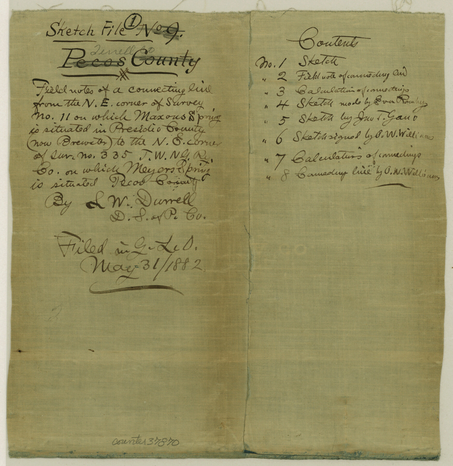
Terrell County Sketch File 1
[Field notes and sketches of connecting line from the NE corner of survey no. 11 where Maxon's Springs is located in Brewster County to the NE corner of survey no. 335, T. W. & N. G. R.R. Co. where Meyer's Spring is located in Terrell County]
-
Map/Doc
37870
-
Collection
General Map Collection
-
Object Dates
1881-1884 (Creation Date)
-
People and Organizations
L.W. Durrell (Surveyor/Engineer)
-
Counties
Terrell Brewster
-
Subjects
Surveying Sketch File
-
Height x Width
9.1 x 8.8 inches
23.1 x 22.4 cm
-
Medium
paper, manuscript
-
Features
Maxon's Spring
Meyer's Springs
Rio Grande
Part of: General Map Collection
San Patricio County NRC Article 33.136 Sketch 4A

Print $3.00
- Digital $50.00
San Patricio County NRC Article 33.136 Sketch 4A
Size 17.0 x 11.0 inches
Map/Doc 94696
Liberty County Sketch File 68

Print $24.00
- Digital $50.00
Liberty County Sketch File 68
Size 11.0 x 8.5 inches
Map/Doc 94021
Pecos County Sketch File 29

Print $20.00
- Digital $50.00
Pecos County Sketch File 29
1929
Size 26.1 x 15.8 inches
Map/Doc 12170
Nolan County Working Sketch 10

Print $40.00
- Digital $50.00
Nolan County Working Sketch 10
1971
Size 78.9 x 37.0 inches
Map/Doc 71301
Gregg County Boundary File 8

Print $8.00
- Digital $50.00
Gregg County Boundary File 8
Size 14.0 x 8.6 inches
Map/Doc 54019
Lynn County Boundary File 7a

Print $8.00
- Digital $50.00
Lynn County Boundary File 7a
Size 14.3 x 8.8 inches
Map/Doc 56647
Maps of the new and popular St. Louis and Texas Short Line composed of the St. Louis, Iron Mountain & Southern, Texas & Pacific and International & Great Northern Railways

Print $20.00
- Digital $50.00
Maps of the new and popular St. Louis and Texas Short Line composed of the St. Louis, Iron Mountain & Southern, Texas & Pacific and International & Great Northern Railways
1874
Size 19.0 x 32.0 inches
Map/Doc 93638
Brown County Sketch File 25

Print $6.00
- Digital $50.00
Brown County Sketch File 25
1890
Size 11.2 x 15.4 inches
Map/Doc 16623
Roberts County Working Sketch 44

Print $20.00
- Digital $50.00
Roberts County Working Sketch 44
1991
Size 26.8 x 42.6 inches
Map/Doc 63570
Jefferson County Rolled Sketch 4

Print $40.00
- Digital $50.00
Jefferson County Rolled Sketch 4
Size 36.7 x 65.3 inches
Map/Doc 9269
Matagorda County Sketch File 38

Print $20.00
- Digital $50.00
Matagorda County Sketch File 38
1904
Size 24.4 x 33.0 inches
Map/Doc 12046
Trinity County Working Sketch Graphic Index

Print $20.00
- Digital $50.00
Trinity County Working Sketch Graphic Index
1946
Size 41.3 x 41.6 inches
Map/Doc 76718
You may also like
Madison County Working Sketch 9

Print $20.00
- Digital $50.00
Madison County Working Sketch 9
1982
Size 15.7 x 21.1 inches
Map/Doc 70771
Hidalgo County Rolled Sketch 8

Print $20.00
- Digital $50.00
Hidalgo County Rolled Sketch 8
1905
Size 20.1 x 26.3 inches
Map/Doc 6209
Henderson County Working Sketch 23

Print $20.00
- Digital $50.00
Henderson County Working Sketch 23
1951
Size 28.2 x 24.2 inches
Map/Doc 66156
Uvalde County Working Sketch 18

Print $20.00
- Digital $50.00
Uvalde County Working Sketch 18
1948
Size 33.0 x 26.5 inches
Map/Doc 72088
Fort Bend County Sketch File 28

Print $40.00
- Digital $50.00
Fort Bend County Sketch File 28
Size 13.7 x 8.6 inches
Map/Doc 22979
Briscoe County Sketch File B

Print $40.00
- Digital $50.00
Briscoe County Sketch File B
1900
Size 23.6 x 37.0 inches
Map/Doc 10998
The Texas and Oklahoma Official Railway and Hotel Guide Map

Print $20.00
The Texas and Oklahoma Official Railway and Hotel Guide Map
1906
Size 23.5 x 23.4 inches
Map/Doc 79316
Val Verde County Working Sketch 40

Print $20.00
- Digital $50.00
Val Verde County Working Sketch 40
1943
Size 31.5 x 29.8 inches
Map/Doc 72175
Taylor County Rolled Sketch 27B

Print $20.00
- Digital $50.00
Taylor County Rolled Sketch 27B
Size 19.2 x 17.7 inches
Map/Doc 7920
Galveston County Rolled Sketch 44

Print $20.00
- Digital $50.00
Galveston County Rolled Sketch 44
1991
Size 24.9 x 36.9 inches
Map/Doc 5973
Taylor County Rolled Sketch 28

Print $20.00
- Digital $50.00
Taylor County Rolled Sketch 28
Size 34.4 x 23.9 inches
Map/Doc 7921
Newton County Working Sketch 29

Print $20.00
- Digital $50.00
Newton County Working Sketch 29
1955
Size 21.2 x 39.8 inches
Map/Doc 71275